Taklamakan Desert (Biodiversity)
Contents
Taklamakan Desert

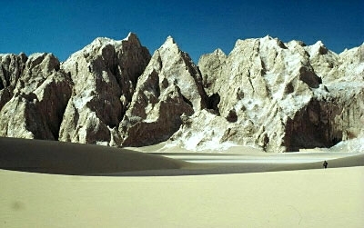
Arxan, Xijiang, China (Photograph by WWF / Ronald Petocz)
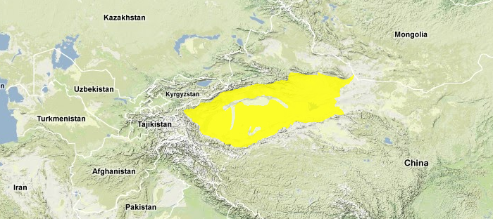
The Taklamakan Desert is a xeric ecoregion, located between China's Kunlun and Tian Shan Mountains. The largest desert in China, the Taklamakan is also the world's largest shifting-sand desert, eighty-five percent of this ecoregion comprising sand dunes that support minimal to no vegetation. In spite of the harsh environment, there are a total of 409 vertebrate species that survive in the Taklamakan Desert. The earliest recorded presence of man in this desert was from the development of the Northern Silk Road, looping around the northern portion of the Taklamakan Desert as early as the first millennium BC, when the Chinese used this route for military campaigns toward the Middle East; moreover, this portion of the Silk Road became important as the earliest trade route between China and the Mediterranean Basin.
There is little biodiversity in such a harsh environment, yet such mammals as the Wild Bactrian Camel (Camelus ferus) and Asiatic Wild Ass (Equus hemionus) manage to persist. Unusable as farmland for humans, the Taklamakan Desert remains largely ecologically intact, although a history of nuclear testing in Lop Nor represents a considerable ecological threat.
Location and general depiction
The Taklamakan is China's largest, driest and hottest desert. It fills the expansive Tarim Basin between the Kunlun Mountains and the Tibetan Plateau to the south, and the Tian Shan (Celestial Mountains) to the north. Located farther from the ocean than almost any place on Earth, this region is completely cut off from the effects of the Asian monsoon. Arctic storms from the north are also essentially blocked by the encircling mountains at the north and northwest. Because the basin is essentially endorheic (lacks external drainage), salt has accumulated over a large fraction of the ecoregion. The Taklamakan is also known as one of the world's largest shifting-sand deserts. Fully 85 percent of the total land area consists of mobile, unstabilised sand dunes that may reach a relative height (from base to crest of an individual dune) of 100 to 200 metres (m), and are virtually devoid of vegetation.
On the alluvial fans that spread outward from the foot of the mountains to the floor of the basin, perennial freshwater springs are fed by mountain snowmelt. The Tarim River also flows across the basin from west-to-east. In these places, the oases created by fresh surface water support a distinct ecoregion, the Tarim Basin Deciduous Forest.
A transect through the Tarim Basin from high mountain slopes to the edge of the desert reveals a distinctive sequence of landforms. Higher on the slopes, exposed surfaces are denudational: they are sculpted by the removal of material through wind and water erosion (Weathering). Basin landscapes are depositional: they consist of gravel, sand, silt, or clay, depending on the velocity of the water transporting material to the site. The floor of the basin includes large expanses of water or wind-deposited sand. Toward the margin, this sand is fixed and stable. Closer to the middle, it consists of unconsolidated, shifting dunes. Among the dunes are areas of salt marsh and salt flats that may be sporadically inundated. The lowest elevation point in the Tarim Basin is 154 metres below sea level.
Diurnal and seasonal temperature variations are both severe in this arid, continental basin. Day and night temperatures may differ by 20°C. Winter-summer temperatures may differ by 30°C. The overall climate, however, is warmer here than the other desert regions of China due to lower latitude and low elevation. In the center of the basin, precipitation is scant: less than 10 millimetres (mm) per year. But this increases to about 100 mm per year at the foot of the mountains and may reach 400 to 800 mm per year on the upper slopes above 3000 m elevation which are high enough to intercept arctic storms during winter. The presence of an adequate snowpack in the high mountains explains the large oases in the basin. These once supported deciduous poplar forest, but today they have been converted to irrigated agriculture.
Biodiversity features
There are a total of 409 vertebrates that characterise the macro-fauna of the Taklamakan Desert. A number of these taxa are classified as special status animals, including Endangered (EN); Vulnerable (VU) or Near Threatened (NT) standing.
Flora
Most of the Tarim Basin, including the Taklamakan Desert, consists of shifting sand with virtually no vegetation. When sand movement slows, dunes may be colonized by such plant species as Alhagi sparsifolia, Scorzonera divaricata, and Karelinia caspia. Peripheral areas consist of more stable gravel substrates where vegetation cover may approach five percent. Dominant plant species here include the shrubs Ephedra przewalskii, which prefers sandy places, and Nitraria sphaerocarpa; however, in present times the vegetation of the Tarim Basin is extremely depauperate. The northern margin of the Taklamakan Desert, and areas at the periphery of the Tarim River riparian zone, support steppe vegetation dominated by Saxaul (Haloxylon spp.) together with other salt-tolerant shrubs.
Mammals
Partly because it is so inhospitable to humans, the Taklamakan Desert continues to support small populations of mammals such as Wild Bactrian Camel (Camelus ferus) and Asiatic Wild Ass (Equus hemionus) that have been extirpated in other parts of China.
All of the 500 Bactrian Camels that survive in the wild in China inhabit the Taklamakan, mostly in the area to the east of the (now desiccated) Lop Nor Lake. Arjin Shan Wild Camel Nature Reserve (15,125 square kilometres (km2) has been mapped to conserve habitat for this species, but the wild camels are still thought to be in a state of decline. An extension of Arjin Shan Nature Reserve is located at higher elevation in the basins of the Kunlun Mountains to the south. If these two large protected areas are managed successfully, they will be valuable for desert conservation in China. An approximately equal number of Wild Bactrian Camel individuals occur in Great Gobi National Park in Mongolia.
Other mammals found in the Taklamakan Desert include the: Alpine Musk Deer (Moschus chrysogaster EN); Argali (Ovis ammon NT); Himalyan Marmot (Marmota himalayana); Ila Pika (Ochotona iliensis); Schreiber's Long-fingered Bat (Miniopterus schreibersi NT), found in rock crevices and caves in hilly areas; and Marbled Polecat (Vormela peregusna VU).
Reptiles
A number of species of snakes, lizards and geckos are found in the Taklamakan Desert. Example reptile taxa within this desert ecoregion include the Ching Hai Toadhead Agama (Phrynocephalus vlangalii), a reptile that shelters in burrows to protect from the extreme low temperatures of winter nights; and the Gobi Naked-toed Gecko (Cyrtopodion elongatum).
Amphibians
A limited presence of amphibians occurs in the Taklamakan Desert. A single amphibian is found here that is endemic to the Taklamakan Desert: Pewzow's Toad (Pseudepidalea pewzowi). The Siberian Frog (Rana chensinensis) is also found in this ecoregion; another anuran species occurring in the Taklamakan Desert is Pseudepidalea oblonga.
Ecological status
Resource problems include the history of nuclear testing in Lop Nor and declining air quality as wind blows dust from lakes that have become dry due to irrigation. On April 15th, 1998, a dust storm in western China produced a very large atmospheric dust cloud that was transported across the Pacific Ocean and caused elevated aerosol concentrations 10 days later over the Pacific Coast of North America.
Types and severity of threats
Through a program of central planning, the Chinese national government operates an extensive relocation program of the Chinese people in order to meet central government objectives; further population transfers to the Taklamakan region due to translocation of people from eastern China threatens the existing oases, because of water scarcity, considerable water being required to expand crop irrigation for the relocated populations.
The wild camel gene pool could be threatened by interbreeding with domestic camels, which are abundant in many areas of the Tarim Basin. Strategies to promote gene flow between the Chinese and Mongolian wild camel populations could be pursued if, in fact, these populations had interbred in recent historic time.
Justification of ecoregion delineation
The ecoregion boundary is based on the CVMCC Vegetation Map of China: classes desert steppe, shrubby, and rocky desert with sand dunes, saline soil, and sparsely vegetated areas as dominant land cover. This is comparable to the Tarim Basin biogeographic subunit in the Takla-Makan-Gobi Desert.
Further reading
- Chinese Vegetation Map Compilation Committee. 1979. Vegetation map of China. Map (1:10,000,000). Science Press, Beijing, China.
- V.I. Grubov. 1999. Plants of Central Asia, vol. 1 Science Publishers, Inc., Enfield, New Hampshire, USA. (translated from: Rasteniya Central'nov Asii, vol. 1, 1963. Nauka Publishers, Leningrad)
- C.Michael Hogan. Northern Silk Road. ed. A.Burnham, Megalithic Portal
- A. Ibrahim and A. Muhammad. 2000. Population patterns of three dominant plant species on the southern border of Taklamakan Desert, China. Symposium on Plant Population Viability Analysis, Technische Universitat Munchen , 5/31-6/3, 2000. Retrieved (2000).
- L. Laidler and K. Laidler. 1996. China's Threatened Wildlife. Blandford, London. ISBN: 0713727055
- J.Lu. 1995. Ecological significance and classification of Chiense wetlands. Vegetatio 118: 49-56.
- John Man. 1997. Gobi, Tracking the Desert. Yale University Press, New Haven, CT. ISBN: 0300076096
- J.Mackinnon, M.Sha, C.Cheung, G.Carey, Z.Xiang, and D.Melville. 1996. A biodiversity review of China. World Wide Fund for Nature, Hong Kong.
- J.MacKinnon. 1996. Wild China. The MIT Press, Cambridge MA. ISBN: 0262133296
- E.M.Murzayev. 1971. The Deserts of Dzungaria and the Tarim Basin, In S. R. Eyre editor, World vegetation types. Columbia University Press, New York. ISBN: 0231035039
- Ji Zhao editor. Zheng Guangmei, Wang Huadong, Xu Jialin. 1990. The Natural History of China. McGraw Hill Publishing Company, New York. ISBN: 0070107521
| Disclaimer: This article contains some information that was originally published by the World Wildlife Fund. Topic editors and authors for the Encyclopedia of Earth have edited its content and added new information. The use of information from the World Wildlife Fund should not be construed as support for or endorsement by that organization for any new information added by EoE personnel, or for any editing of the original content. |
