Tajikistan
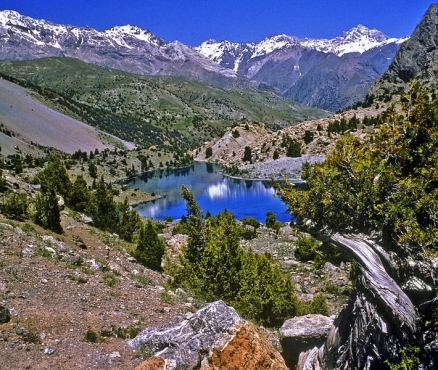
Fan Mountains, Tajikistan. Source: T.Voekler/Wikimedia Commons
Countries and Regions of the World Collection  Tajikistan is a landlocked nation of seven-and-three-quarters million people in central Asia, west of China and north of Afghanistan.
Tajikistan is a mountainous region dominated by the Trans-Alay Range in the north and the Pamirs in the southeast. The highest point, Qullai Ismoili Somoni (formerly Communism Peak), was the tallest mountain in the former USSR.
|
|

Its major environmental issues include:
- inadequate sanitation facilities;
- increasing levels of soil salinity;
- industrial pollution; and,
- excessive pesticides
It is susceptible to earthquakes and floods
The Tajik people came under Russian rule in the 1860s and 1870s, but Russia's hold on Central Asia weakened following the Revolution of 1917.
Bolshevik control of the area was fiercely contested and not fully reestablished until 1925.
Much of present-day Sughd province was transferred from the Uzbek SSR to the newly formed Tajik SSR in 1929. Ethnic Uzbeks form a substantial minority in Tajikistan.
Tajikistan became independent in 1991 following the breakup of the Soviet Union, and experienced a civil war between regional factions from 1992-97.
Tajikistan experienced several security incidents in 2010, including a mass prison-break from a Dushanbe detention facility, the country's first suicide car bombing in Khujand, and armed conflict between government forces and opposition militants in the Rasht Valley.
The country remains the poorest in the former Soviet sphere.
Attention by the international community since the beginning of the NATO intervention in Afghanistan has brought increased economic development and security assistance, which could create jobs and strengthen stability in the long term. Tajikistan is seeking WTO membership and has joined NATO's Partnership for Peace.

Contents
Geography
At 36'40' northern latitude and 41'14' eastern longitude, Tajikistan is located between Kyrgyzstan and Uzbekistan to the north and west, China to the east, and Afghanistan to the south. Tajikistan is home to some of the highest mountains in the world, including the Pamir and Alay ranges. Ninety-three percent of Tajikistan is mountainous with altitudes ranging from 984 feet to 24,589 feet, with nearly 50% of Tajikistan's territory above 10,000 feet. Earthquakes of varying degrees are frequent. The massive mountain ranges are cut by hundreds of canyons and gorges; at the bottom of these run streams which flow into larger river valleys where the majority of the country's population lives and works. The principal rivers of Central Asia, the Amu Darya and the Syr Darya, both flow through Tajikistan, fed by melting snow and glaciers in the mountains of Tajikistan and Kyrgyzstan. Flooding and landslides sometimes occur during the annual spring thaw.
Location: Central Asia, west of China, south of Kyrgyzstan
Geographic Coordinates: 39 00 N, 71 00 E
Area: 143,100 sq km (land: 141,510 sq km; water: 2,590 sq km)
Land Boundaries: 3,651 km (Afghanistan 1,206 km, China 414 km, Kyrgyzstan 870 km, Uzbekistan 1,161 km)
In 2006, China and Tajikistan pledged to commence demarcation of the revised boundary agreed to in the delimitation of 2002.
Talks continue with Uzbekistan to delimit border and remove minefields
Disputes in Isfara Valley delay delimitation with Kyrgyzstan
Natural Hazards: earthquakes; floods
Terrain: Pamir and Alay Mountains dominate landscape; western Fergana Valley in north, Kofarnihon and Vakhsh Valleys in southwest. The highest point is Qullai Ismoili Somoni (Pik Imeni Ismail Samani) (7,495 m) and lowest point Syr Darya (Sirdaryo) (300 m).
Climate: midlatitude continental, hot summers, mild winters; semiarid to polar in Pamir Mountains

Source: NASA/Wikimedia Commons
Ecology and Biodiversity
Source: Worldwildlife Fund
- Gissaro-Alai open woodlands
- Pamir alpine desert and tundra
- Badghyz and Karabil semi-desert
See also: Biological diversity in the mountains of Central Asia
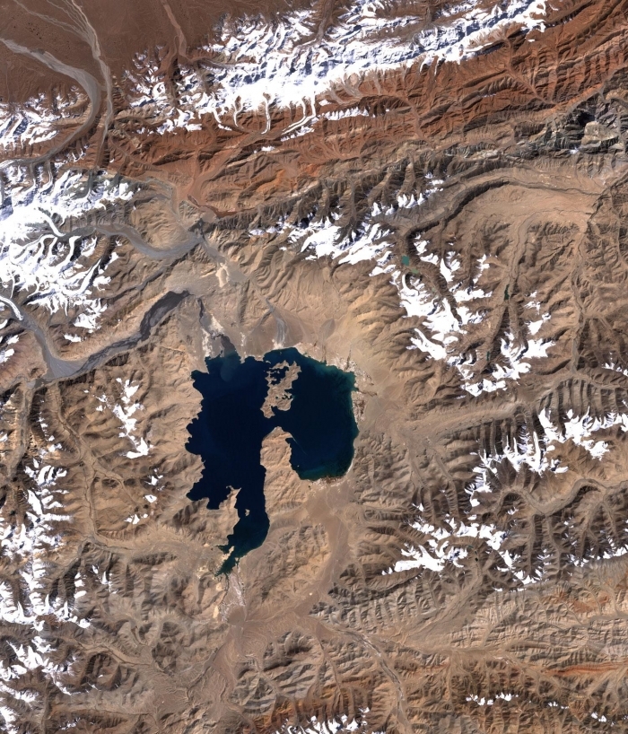
Near the center of this scene is the mountain lake Kara-Kul, located in eastern Tajikistan, high in the Pamir Mountain Range near the Afghan border. The 25-kilometer (16-mile) diameter lake sits at an elevation of about 4,000 meters (about 12,000 feet) above sea level. Kara-Kul was formed from a meteorite impact approximately 25 million years ago, leaving a crater with a rim diameter of 45 kilometers (28 miles). Islands formed from the central uplift can be seen in the northern and southern parts of the lake. Interestingly, the Kara-Kul impact structure remained unidentified until it was discovered though studies of imagery taken from space. This image was taken by the Landsat 7 satellite on September 28, 2001. Source: NASA/USGS
People and Society
Population: 7,768,385 (July 2012 est.)
Contemporary Tajiks are the descendants of various ancient Iranian inhabitants of Central Asia, in particular the Soghdians and the Bactrians, and possibly other groups, with an admixture of Mongols and Turkic peoples. The largely Shi’a inhabitants of the Pamir mountains speak a number of mutually unintelligible eastern Iranian dialects quite distinct from the Tajik spoken in the rest of the country. Until the 20th century, people in the region tended to identify themselves more by way of life--nomadic versus sedentary--and place of residence than by ethnic group. The distinction between ethnic Tajiks and Uzbeks was not always precise, and people in the region often used--and continue to use--each other's languages. The Soviets tended to reify ethnicity, and drew Central Asian republican boundaries so that they balanced ethnic representation in fertile areas such as the Ferghana Valley while also making large-scale ethnic mobilization difficult.
Ethnic Groups: Tajik 79.9%, Uzbek 15.3%, Russian 1.1%, Kyrgyz 1.1%, other 2.6% (2000 census)
Age Structure:
0-14 years: 33.9% (male 1,316,623/female 1,270,899)
15-64 years: 62.7% (male 2,368,554/female 2,413,982)
65 years and over: 3.4% (male 108,896/female 148,246) (2011 est.)
Population Growth Rate: 1.823% (2012 est.)
Birthrate: 25.93 births/1,000 population (2012 est.)
Death Rate: 6.49 deaths/1,000 population (July 2012 est.)
Net Migration Rate: -1.21 migrant(s)/1,000 population (2012 est.)
Life Expectancy at Birth: 66.38 years
male: 63.3 years
female: 69.61 years (2012 est.)
Total Fertility Rate: 2.85 children born/woman (2012 est.)
Languages: Tajik (official), Russian widely used in government and business
Literacy (age 15 and over can read and write): 99.2% (2000 census)
Urbanization: 26% of total population (2010) growing at an annual rate of change of 2.2% (2010-15 est.)
History
The current Tajik Republic hearkens back to the Samanid Empire (A.D. 875-999), which ruled what is now Tajikistan as well as territory to the south and west, as its role model and name for its currency. During their reign, the Samanids supported the revival of the written Persian language in the wake of the Arab Islamic conquest in the early 8th century and played an important role in preserving the culture of the pre-Islamic Persian-speaking world. They were the last Persian-speaking empire to rule Central Asia.
The expanding Russian Empire encompassed the territory that is now Tajikistan, along with most of the rest of Central Asia, during the late 19th and early 20th centuries. Russian rule collapsed briefly after the Russian Revolution of 1917, as the Bolsheviks consolidated their power and were embroiled in a civil war in other regions of the former Russian Empire. As the Bolsheviks attempted to regain Central Asia in the 1920s, an indigenous Central Asian resistance movement based in the Ferghana Valley, the "Basmachi movement," resisted but was largely eliminated by 1925. Tajikistan became fully established under Soviet control with the creation of Tajikistan as an autonomous Soviet socialist republic within Uzbekistan in 1924, and as an independent Soviet socialist republic in 1929. The northern Sughd region, previously part of the Uzbek republic, was added to the Tajik republic at this time.
The Republic of Tajikistan gained its independence during the breakup of the Union of Soviet Socialist Republics (U.S.S.R.) on September 9, 1991 and soon fell into a civil war. From 1992 to 1997 internal fighting ensued between old-guard regionally based ruling elites and disenfranchised regions, democratic liberal reformists, and Islamists loosely organized in a United Tajik Opposition (UTO). Other combatants and armed bands that flourished in this civil chaos simply reflected the breakdown of central authority rather than loyalty to a political faction. The height of hostilities occurred between 1992 and 1993. By 1997, the predominantly Kulyabi-led Tajik Government and the UTO had negotiated a power-sharing peace accord and implemented it by 2000. Once guaranteed 30% of government positions, former oppositionists have almost entirely been removed from government as President Rahmon has consolidated power.
The last Russian border guards protecting Tajikistan's 1,344 km border with Afghanistan completed their withdrawal in July 2005. Russia maintains its military presence in Tajikistan with the basing of the Russian 201st Motorized Rifle Division that never left Tajikistan when it became independent. Most of these Russian-led forces, however, are local Tajik noncommissioned officers and soldiers.
Government
Government Type: republic
In June 2003, Tajikistan held a flawed referendum to enact a package of constitutional changes, including a provision to allow President Rahmon the possibility of re-election to up to two additional 7-year terms after his term expired in 2006. Tajikistan's 2006 presidential election and 2010 parliamentary elections were considered to be flawed and unfair but peaceful. President Rahmon secured a new 7-year term in the November 6, 2006 election. The Organization for Security and Cooperation in Europe's Office for Democratic Institutions and Human Rights (ODIHR) determined that democratic practices were not fully tested "due to the absence of genuine competition, which provided voters with only nominal choices." There were four other candidates on the ballot but no strong opposition candidate. The strongest opposition party, the IRPT, decided not to field a candidate and two other parties (the DPT and SDPT) boycotted the presidential election. The ruling party secured 55 of the 63 seats in the 2010 parliamentary elections, which failed to meet many key ODIHR standards on democratic elections. Some observers saw them as even worse than the flawed 2005 parliamentary elections.
Lack of transparency in the legislative process and significant concerns regarding due process demonstrate the weakness of civil society in the country. Corruption is pervasive, and numerous observers have noted that power has been consolidated into the hands of a relatively small number of individuals.
Capital: Dushanbe - 704,000 (2009)
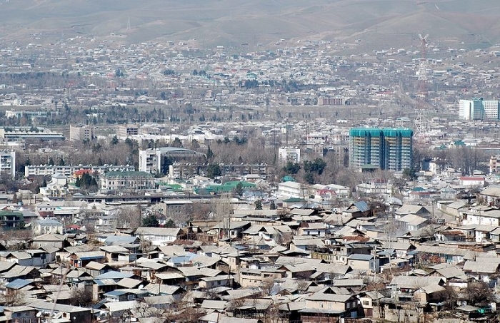
Panorama of Dushanbe, 2007. Source Wikimedia Commons.
Administrative divisions: 2 provinces (viloyatho, singular - viloyat) and 1 autonomous province* (viloyati mukhtor); Viloyati Khatlon (Qurghonteppa), Viloyati Mukhtori Kuhistoni Badakhshon [Gorno-Badakhshan]* (Khorugh), Viloyati Sughd (Khujand); the rest of the country consists of "districts under republican subordination," ruled directly from Dushanbe. Note: the administrative center name follows in parentheses
Independence Date: 9 September 1991 (from the Soviet Union)
Legal System: Tajikistan accepts compulsory International Court of Justice (ICJ) jurisdiction; and accepts International criminal court (ICCt) jurisdiction
International Environmental Agreements
Tajikistan is party to international agreements on: Biodiversity, Climate Change, Climate Change-Kyoto Protocol, Desertification, Environmental Modification, Ozone Layer Protection, and Wetlands.
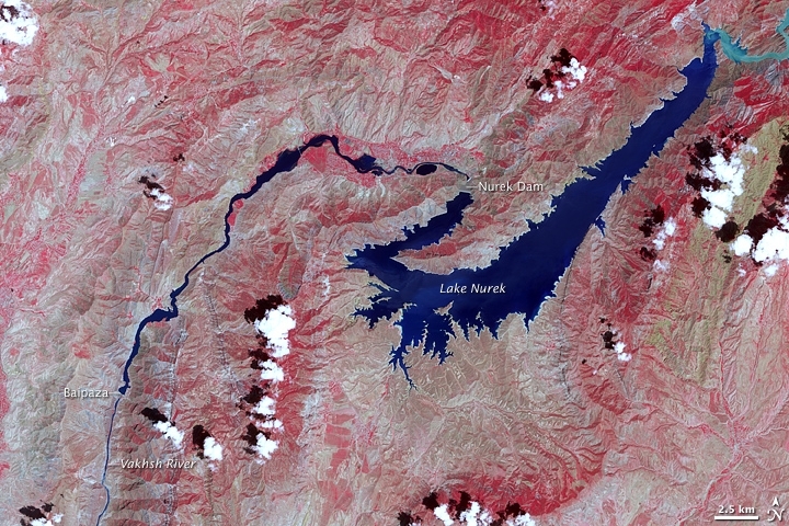
The Vakhsh River in Tajikistan embodies several superlatives: it is the largest river in the country, the most important source of electricity, and it is home to world’s tallest (completed) engineered dam, the Nurek. The river flows southwest from the glacier-capped mountains of Kyrgyzstan and crosses the entire length of central Tajikistan.
This false-color image shows the central part of the river, including the Nurek Dam and resulting reservoir. The image uses visible and near-infrared light to make the area’s sparse vegetation stand out from the surrounding terrain. Vegetation is red, bare ground is tan, and water is blue. Upstream of Lake Nurek, at a sharp bend in the river, the waters are pale blue; the brightness comes from sediment. The image was captured by the Advanced Spaceborne Thermal Emission and Reflection Radiometer (ASTER) on NASA’s Terra satellite on July 9, 2007.
The Nurek is one of five operational hydroelectric dams on the Vakhsh River; four more are in the planning or construction phases. The existing dams are responsible for about 90 percent of the country’s electricity, but at times, they have been insufficient to keep up with demand. Periodically, electricity has been rationed. Currently, the Nurek Dam generates the most electricity (3,000 megawatts), but the Rogun Dam, which is under construction upstream, will eventually exceed it by producing 3,600 megawatts.
Because the country depends so heavily on the Vakhsh for electricity (as well as for agricultural irrigation), the potential impact of global warming on the glaciers that feed the river is a major environmental concern. Other risks to hydroelectric infrastructure come from seismic activity. The area is prone to earthquakes, which sometimes cause landslides that block the river and damage infrastructure.
Source: NASA. Credit: NASA image created by Jesse Allen, using data provided courtesy of NASA/GSFC/METI/ERSDAC/JAROS, and the U.S./Japan ASTER Science Team. Caption by Rebecca Lindsey.
Water
Total Renewable Water Resources: 99.7 cu km (1997)
Freshwater Withdrawal: 11.96 cu km/yr (4%/5%/92%) (4% domestic, 5% industrial, 92% agricultural)
Per Capita Freshwater Withdrawal: 1,837 cu m/yr (2000)
Access to improved drinking water resources: 70% of population
Access to improved sanitation facilities: 94% of population
See: Water profile of Tajikistan
Agriculture
Agricultural products: cotton, grain, fruits, grapes, vegetables; cattle, sheep, goats
Irrigated Land: 7,220 sq km (2008)

Lake Sarez (top), deep in the Pamir mountains of Tajikistan, was created 90 years ago when a strong earthquake triggered a massive landslide that, in turn, became a huge dam along the Murghob River, now called the Usoi Dam. The resulting lake is perched above surrounding drainages at an elevation greater than 3000m, and is part of the watershed that drains the towering Akademi Nauk Range (see the regional image, lower). The lake is 61 km long and as deep as 500 m, and holds an estimated 17 cubic km of water. The area experiences considerable seismic activity, and scientists fear that part of the right bank may slump into the lake, creating a huge wave that will top over and possibly breach the natural dam. Such a wave would create a catastrophic flood downstream along the Bartang, Panj and Amu Darya Rivers, perhaps reaching all the way to the Aral Sea. Currently, central Asian governments, as well as the World Bank and the UN are monitoring the dam closely, and have proposed gradually lowering the lake level as a preventive measure. Source: NASA
Resources
Natural Resources: hydropower, some petroleum, uranium, mercury, brown coal, lead, zinc, antimony, tungsten, silver, gold
Land Use:
Economy
Tajikistan is the poorest Commonwealth of Independent States (CIS) country and one of the poorest countries in the world. Foreign revenue is precariously dependent upon exports of cotton and aluminum and on remittances from Tajik migrant workers abroad, mainly in Russia. The economy is highly vulnerable to external shocks. Despite this, Tajikistan managed modest growth during the height of the recent economic crisis, and growth picked up again in 2010 (6.5%) and 2011 (7.4%).
Tajikistan has great hydropower potential and has focused on attracting investment for projects for internal use and electricity exports. Meanwhile, the country faces severe electricity shortages, particularly during the winter and beyond, when most of Tajikistan's inhabitants receive little or no electricity for weeks at a time. The government sees the construction of the massive Roghun hydroelectric dam as the solution to the country’s chronic energy woes, but the dam has been a source of increasing friction with Uzbekistan.
Tajikistan has followed a relatively strict fiscal and monetary policy, which has resulted in macroeconomic stability. However, government interference in the economy and massive corruption stifle economic growth and private investment. The government has attracted state-led investment for major infrastructure projects, particularly from China, rather than implementing the necessary economic reforms to attract private investors. Two-thirds of the workforce of Tajikistan is in agriculture, where wages are abysmally low and sometimes non-existent. Tajikistan struggles to implement agricultural reforms that would allow many farmers to grow the crop of their choice, rather than being forced to grow cotton, as has been the practice from Soviet times. Income from narcotics trafficking, while difficult to quantify, has an increasingly visible impact on the Tajik economy.
Because of a lack of employment opportunities in Tajikistan, as many as a million Tajik citizens work abroad, almost all of them in Russia, supporting families in Tajikistan through remittances.
Less than 7% of the land area is arable. Cotton is the most important crop, and its production is closely monitored, and in many cases controlled, by the government. In the wake of the National Bank of Tajikistan's admission in December 2007 that it had improperly lent money to investors in the cotton sector, the IMF canceled its program in Tajikistan.
A reform agenda is underway, according to which over half a billion dollars in farmer debt is being forgiven, and IMF assistance has been reinstated.
Mineral resources include silver, gold, uranium, and tungsten.
Industry consists only of a large aluminum plant, hydropower facilities, and small obsolete factories mostly in light industry and food processing.
The civil war (1992-97) severely damaged the already weak economic infrastructure and caused a sharp decline in industrial and agricultural production.
Tajikistan's economic situation remains fragile due to uneven implementation of structural reforms, corruption, weak governance, seasonal power shortages, and the external debt burden.
Electricity output expanded with the completion of the Sangtuda-1 hydropower dam - finished in 2009 with Russian investment. The smaller Sangtuda-2, built with Iranian investment, began operating in 2011.
The government of Tajikistan is pinning major hopes on the massive Roghun dam which, if finished according to Tajik plans, will be the tallest dam in the world and significantly expand electricity output. The World Bank has agreed to fund technical, economic, social, and environmental feasibility studies for the dam, scheduled to be completed in 2012. In January 2010, the government began selling shares in the Roghun enterprise to its population, ultimately raising over $180 million but Tajikistan will still need significant investment to complete the dam. According to numerous reports, many Tajik individuals and businesses were forced to buy shares. The coerced share sales finally ended in mid-2010 under intense criticism from donors, particularly the IMF.
Food and fuel prices in 2011 increased to the highest levels seen since 2002 due in part to an increase in rail transport tariffs through Uzbekistan. Tajikistan imports approximately 60% of its food and 90% of that comes by rail.
GDP: (Purchasing Power Parity): $16.01 billion (2011 est.)
GDP: (Official Exchange Rate): $6.8 billion (2011 est.)
GDP- per capita (PPP): $2,000 (2011 est.)
GDP- composition by sector:
agriculture: 18.1%
industry: 22.4%
services: 59.4% (2011 est.)
Industries: aluminum, cement, vegetable oil
Currency: Tajikistani somoni (TJS)