Plate tectonics
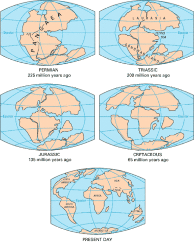
In the 19th and early 20th centuries, several scientists suggested that the continental masses had the ability to move across the Earth's surface. These early theories of continental drift were based on the following evidence:
- Locations of fossil occurrences suggested that some of the continental masses may have been connected in the geological past.
- Paleoclimatic evidence indicates that now tropical regions on some continents had polar climates in past Ice ages. This may indicate that these regions were located at different latitudes.
- Some continents seem to fit together like a jigsaw puzzle.
- Some geologic deposits of rocks on the East coast of North and South America are similar to deposits found on the West coast of Africa and Europe.
During the first 30 years of the 20th century the theory of continental drift was actively debated among geo-scientists. However, during the following 30 year period, debate on this theory waned because of the inability of scientists to propose a mechanism to cause the movement of the continental masses.
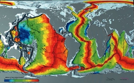
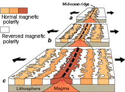
In the 1960s, the theory was resurrected with the discovery of alternating patterns of rock magnetism in surface sea-floor rocks. Scientists had previously discovered that the magnetic orientation of certain crystals in rocks varies from normal to reversed polarity depending on the date that the rock was formed and solidified. It was also discovered that these magnetic reversals were common and occurred on a regular basis. The polarity patterns found in the rocks at the ocean floor seemed to mirror themselves either side of the mid-oceanic ridge found at the centers of the ocean basins. Further, geologic dating of the rocks indicated the age of the sea-floor rocks increase as one moved away from the mid-oceanic ridge (see Figure 1). Based on this information, scientists developed the theory of sea-floor spreading which suggested that volcanic rift zones at the mid-oceanic ridge represent areas of crustal creation.
The diagram in Figure 2 illustrates the process of crustal creation and the magnetic striping process. In Figure 2, illustrations "a" to "c" represent a sequence in time from the past to the present. In illustration a, rocks of normal polarity are being deposited at the rift zone located along the mid-oceanic ridge. As new rock is created, older rock is pushed away from the ridge. The reversed polarity rock shown in this diagram was created before the current normal polarity layer. Illustration b shows the process some time later. In this diagram, we now have four layers of rock with alternating polarity. By the third illustration, sea-floor spreading and changes in magnetic polarity have created six recognizable layers of rock either side of the rift zone.
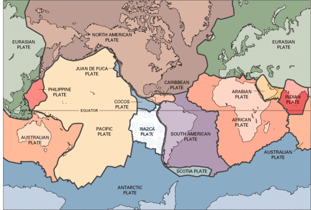
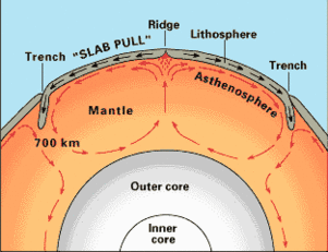
The theory of sea-floor spreading started a revolution in the Earth Sciences. Subsequent research discovered that the Earth's surface was composed of a number of oceanic and continental plates that float on top of the asthenosphere (see Figure 3). Other research suggested that convection currents within the Earth's mantle were responsible for the creation of oceanic crust and the drifting of the continents (Figure 4). In this diagram, it is theorized that convection currents within the Earth's mantle cause the creation of new oceanic crust at the mid-oceanic ridges. Oceanic crust is destroyed at areas where this crust type becomes subducted under lighter continental crust. This process also creates the deep oceanic trenches.
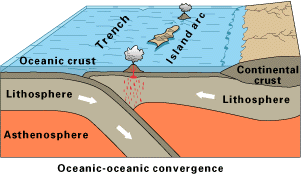
The theory of plate tectonics offered new and more scientifically sound explanations for a number of observed geologic phenomena. For example, the following diagrams illustrate the three types of plate convergence and describe some of the geologic repercussions of these processes. The first diagram models the tectonic convergence of two oceanic plates (Figure 5).
In this type of a collision, one of the plates is subducted under the other creating a deep oceanic trench. The Marianas trench in the Pacific Ocean is created by the collision of the fast-moving Pacific Plate against the slower moving Philippine Plate. Convergence of two oceanic plates also creates chains of volcanic islands called island arcs. Island arcs are created by the friction of subduction which creates hot plumes of magma at the interface of the two plates. These hot plumes of magma then rise to the Earth's surface to form volcanoes. Another phenomena associated with collision and subduction of the plates is earthquakes. The gliding of one plate under the other is not smooth but jerky producing seismic waves.
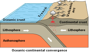
The next diagram shows the collision of an oceanic and a continental plate (Figure 6). In this illustration, the oceanic plate subducts under the lighter continental plate. Once again we get the formation of a trench, volcanoes, and earthquakes. Collision causes sediment deposited on the ocean floor to be piled up at the continental plate boundary. The creation of hot magma plumes also causes the continental crust to deform producing mountains.
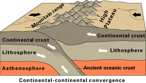
In the final illustration two continental plates collide (Figure 7). Once again one of the crustal plates is subducted under the other producing earthquakes. A mountain range is produced at the plate boundaries because of the deformation of rocks. Some of the rocks in the mountain range may be sedimentary and may have been set down in an ocean environment that existed between the two continental crusts prior to collision.
In summary, modern plate tectonic theory states that the surface crust of the Earth is composed of many independent segments called plates. These plates have the ability to move horizontally by gliding over the plastic asthenosphere (see Figure 8). In some cases, plates can collide with each other at the plate boundaries causing subduction and the production of earthquakes, volcanoes, mountain building, and oceanic trenches. At other plate boundaries, plates may move away from each other because of sea-floor spreading or horizontally move past one another creating transform faults and earthquakes.
Further Reading
