Storms: Still Tough to Predict
On November 30, 2006, the Atlantic hurricane season of 2006 ended without a single hurricane striking the United States. Contrast this with the 2005 season, when an unprecedented 15 hurricanes struck the United States, nearly a third of which attained category 5 status, in which winds exceed 280 km h–1 (174 mph). Worldwide, major storms—called hurricanes, typhoons, or cyclones, depending on location—numbered less than 60 in 2006, down from an annual average of about 80. Clearly, the number and severity of storms vary widely from year to year, and an understanding of the multiple factors involved in their development is necessary for accurate prediction. Examination of the full historic hurricane record from 1880 to current time shows that there has been no increase in frequency or intensity; in fact, there is a slight trend of decreasing severity and frequency. This suggests there is no correlation of hurricanes with carbon dioxide atmospheric concentrations.
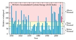
North Atlantic hurricane season. The National Oceanographic and Atmospheric Administration’s Accumulated Cyclone Energy (ACE) Index equals the sum of squares of the 6-h maximum sustained wind speed, in knots, for all storm periods. Blue bars are yearly values as a percentage of the 1951–2000 median value. The red bar was the range predicted in August, 2006 for the 2006 season, whereas that observed was far below normal. Shein et al. 2006
File:Bloom 3.52.jpgPaths of major storms from 1985– 2005. Storms originate over tropical waters, move westward, and then veer to the higher latitudes, where they lose strength. Points show the locations of the storms at 6-hour intervals, and their colors follow the key at the bottom right, where “TD” stands for tropical depression, “TS” for tropical storm (63 kmph–117 kmph), and “1” through “5” for categories of the Saffir-Simpson Hurricane scale. Using User:jdorje/Tracks by Nilfanion on August 5, 2006.
File:Bloom 3.53.jpgCross section of a major storm. Red arrows indicate the upward movement of warm air; blue arrows indicate the movement of cool air.
File:Bloom 3.54.jpgChanges in the power of storms and sea surface temperatures over 54 years. Storm power was assessed as the integral over time of the maximum wind velocity cubed for all storms in the Atlantic and Western Pacific during a given year. Plotted are data smoothed by a low-pass filter. Emanuel 2005.
The primary source of energy that empowers storms is the condensation of water. When water condenses (that is, when it changes phase from a gas to a liquid), it releases large amounts of energy (539 cal/gram) to its surroundings. The 80 W m-2 (19 calories per second per m-2) released annually to the atmosphere through this process exceeds the energy that the atmosphere absorbs from the sun . Conversely, when water evaporates, it removes energy (539 cal/gram) from its surroundings.
Most major storms originate in the tropics when water evaporates from the warm sea surface, rises in the atmosphere, and condenses in the relatively cool higher altitudes. A major storm siphons vast amounts of water vapor up along the wall of its eye that releases roughly 130 × 1012 (trillion) calories per second when it condenses. The majority of this energy generates updrafts that lift storm clouds even higher, to cooler parts of the atmosphere, accelerating condensation. Another portion of this energy drives the ferocious winds that rotate in response to the spin of the planet (the Coriolis effect). The winds kick up water spray, and this, along with the low atmospheric pressures near the eye, enhances surface evaporation. This positive feedback—higher updrafts accelerating condensation and faster winds and lower pressures enhancing surface evaporation—spurs the growth of storms until they pass over land and are cut off from warm surface waters.
Six conditions foster the development of major tropical storms [1]:
1. Sea temperatures must be above 26.5°C (80°F) to a depth of 50 m. Warm temperatures promote
evaporation of water from sea surfaces.
2. Air temperatures must cool rapidly with altitude. The amount of water vapor that an air mass can hold decreases exponentially with temperature ,and so declining temperatures promote condensation as an air mass rises.
3. Relative humidity must be high. An air mass must become saturated with water vapor before water will condense, and moist air is already close to this threshold.
4. A location must be more than 500 km (300 miles) away from the equator. At such a distance from the equator, the angle of Earth’s rotation (Coriolis force) deflects winds from directly blowing into the eye of the storm and dissipating the low pressures there.
5. Vertical wind shears between the sea surface and the middle atmosphere must be less than 10 meters per second (22 mph). Faster vertical air movements disrupt the temperature gradient from the surface to higher altitudes and dries out air at mid altitudes, both of which prevent storms from expanding.
6. A storm must be already brewing. Without a preexisting storm, winds do not begin to spin, and air pressures do not begin to drop.
Climate models try to account for these factors, but the effects of wind shears and the need for a preexisting storm present formidable challenges to their accuracy in predicting the number of major tropical storms in a year. Global climate change, through its warming of sea surface temperatures could increase the severity of storms. Nevertheless, the record-breaking 2005 North Atlantic hurricane season followed by the 2006 season, or lack thereof, only serves to cloud the relationship between global temperatures and storms, and controversy still swirls around this issue. [2]
See Also
References
[1] Gray, W. M. (1979) Hurricanes: Their formation, structure and likely role in the tropical circulation. In: Meteorology Over Tropical Oceans, Shaw, D. B., ed., Royal Meteorological Society, Bracknell, UK. pp. 155-218.
[2] Witze, A. (2006) Tempers flare at hurricane meeting. Nature 441:11-11.
This is an excerpt from the book Global Climate Change: Convergence of Disciplines by Dr. Arnold J. Bloom and taken from UCVerse of the University of California. ©2010 Sinauer Associates and UC Regents
