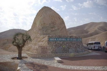
Sea level verification (main)
From The Encyclopedia of Earth
Sea level verification
This marker indicating the sea level is placed on the path from Jerusalem to the Dead Sea.
Berthold Werner
========
Recently Updated
 Sea Level Rise and Coastal Flooding Impacts Viewer Last Updated on 2012-07-25 00:00:00 Sea Level Rise and Coastal Flooding Impacts Viewer Being able to visualize potential impacts from sea level rise is a teaching and planning tool, and the Sea Level Rise Viewer brings this capability to coastal communities. A slider bar is used to show how various levels of sea level rise will impact coastal communities. Completed areas include Mississippi, Alabama, Texas, Florida, and Georgia, with additional coastal counties to be added in the near future. Visuals and the accompanying data and information cover sea level rise inundation, uncertainty, flood frequency, marsh impacts, and socioeconomics. Features of the Sea Level Rise Viewer include: Displaying potential future sea levels Providing simulations of sea level rise at local landmarks Communicating the spatial uncertainty of mapped sea levels Modeling potential marsh migration due... More »
  Future global sea level rise Last Updated on 2012-03-19 00:00:00 The current trajectory for the 21st century global rise of sea level is about .5 cm due to warming of the oceans, partial melting of mountain glaciers and partial melting of Greenland and Antarctica. Global Sea Level Likely to Rise in Future Generations Scientists looked back in time--in the geologic record--to see the future Even if humankind manages to limit global warming to 2 degrees Celsius (3.6 degrees Fahrenheit)--as the Intergovernmental Panel on Climate Change recommends--future generations will likely have to deal with a completely different world. One with sea levels one to two feet higher than at present. The scientists reached their conclusion by studying rock and soil cores taken in Virginia, New Zealand and the Eniwetok Atoll... More »