Saskatchewan River, Canada
| Topics: |
General Description
 (Source: Biodiversity Institute of Ontario)
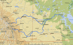
 The Saskatchewan River consists of two large brancheswhich originate in the Columbia icefields in the eastern rages of the Rockie Mountains. From there, they flow from the Rocky Mountains all the way to Lake Winnipeg, converging into one branch just east of Price Albert. The river continues east into Manitoba, where it passes through Cedar Lake and over the Grand Rapids before empting into Lake Winnipeg, Canada. It is the fourth longest river system in Canada, traveling almost 2000 kilometers (km) (including the Bow River). Its drainage area of 334 100 sq. km includes most of southern Alberta and Saskatchewan.
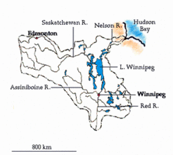 Nelson-Saskatchewan River System. (Source: Biodiversity Institute of Ontario)
 North Saskatchewan
The North Saskatchewan travels 1287 km, draining 122 800 sq. km and discharging an average of 7.73 cubic km per year. It flows northeast from the mountains to a broad forested valley which opens out into the upper prairies of Alberta. There it becomes a fast, winding river incised 60-90 m below the general surface. Further east, in Saskatchewan, the valley opens out again and the river becomes broad and shallow. The main settlements along the river's banks are Edmonton, Battleford and Prince Albert. Although crossed by roads and railways, the river valley is essentially unchanged from the time when native people hunted and camped along its banks. For its pristine natural beauty and its cultural significance, a section of the North Saskatchewan river has been designated as a Canadian Heritage River.
South Saskatchewan
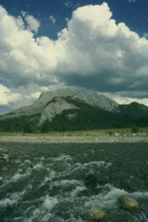 (Source: Biodiversity Institute of Ontario)
 The South Saskatchewan River is over 800 km long, drains an area of 144 300 sq. km and discharges an average of 8.83 cubic km per year. It results from the confluence of the Oldman and Bow [[river]s]. After leaving the Rockies, it flows east in a deeply entrenched valley which later opens to a lightly wooded lowland dotted with shallow lakes and marshes. It continues east as a broad and shallow river with numerous sandbars, even after the confluence with the Red Deer River. Lethbridge, Calgary, Drumheller, Medicine Hat and Saskatoon are the main settlements associated with this branch of the Saskatchewan.
History
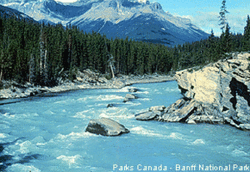 (Source: Photo by Parks Canada-Banff National Park)
 Henry Kelsey of the Hudson Bay Company was the first to discover the Saskatchewan River in 1690, but its full length was not explored until 1741 by La Verendrye. Its name derives from the Cree Indian word "kisiskatchewan" meaning "swift-flowing river." As with the majority of Canada's big [[river]s], the Saskatchewan was used extensively as a route for fur traders. In modern times it is widely used for both irrigation and hydroelectric power.