Santa Ynez - Sulphur Mountains
Contents
Santa Ynez - Sulphur Mountains (Bailey)
 Subsection 261Bb, Santa Barbara area from San Marcos Pass (Robert Ettner)
 Lithology and Stratigraphy
This subsection contains mostly Eocene, Oligocene, Miocene, and Pliocene marine sedimentary rocks, with some Cretaceous marine sedimentary rock. Quaternary alluvium is most extensive in the Ojai Valley and along the coast from Goleta to Carpinteria. There are some small areas of dissected Quaternary marine terraces and dune sand.
Geomorphology
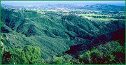
The Santa Ynez Mountains is an east-west trending range of steep mountains with narrow ridges. The Sulphur Mountains trend more toward the west-southwest. They have broader ridges and there are remnants of Quaternary marine terraces on many of them. Floodplains, fluvial terraces, and alluvial fans are most extensive in Ojai Valley. There are small areas of dunes all along the coast. The subsection elevation range is from sea-level up to 4298 feet on Santa Ynez Peak and 4707 feet on Divide Peak. Mass wasting and fluvial erosion are the main geomorphic processes. Coastal marine and eolian processes are important along the coast.
Soils
The soils are mostly Lithic and Typic Xerorthents, Lithic Haploxerolls, and Typic Argixerolls on Cretaceous, Eocene, Oligocene and Miocene sedimentary rocks; and Calcixerollic Xerochrepts, Calcic Pachic Haploxerolls, and shallow Typic Xerorthents on Pliocene sedimentary rocks. Dystric Lithic Xerochrepts are common on Eocene sedimentary rocks in cooler areas. Also, there are Chromoxererts, Palexeralfs, and Haploxerolls on hills of mostly Miocene sedimentary rocks just above the alluvial plain from Goleta to Carpinteria. Haploxerolls, Haploxeralfs, Palexeralfs, and Argialbolls are common on Quaternary nonmarine terraces, and Fluventic and Cumulic Haploxerolls on floodplains. Most, but not all, of the soils are leached free of carbonates. The soils are mostly well drained. Soil temperature regimes are mostly thermic, but mesic on north-facing slopes at higher elevation. Soil moisture regimes are xeric.
Vegetation
The predominant natural plant communities are Coast live oak series in areas with thermic soil temperature regimes, Big-cone Douglas-fir - canyon live oak series in areas with mesic soil temperature regimes, Chamise series on shallow soils, and Mixed chaparral shrublands. There are smaller areas of Purple sage series, Bigpod ceanothus series, and Mixed scrub oak series. The dunes and adjacent uplands with a cover of eolian sand support a succession of plant communities, from bare dune through herbaceous communities and Coyote bush series to California sagebrush series on stabilized dunes.
Characteristic series by lifeform include:
Climate
The mean annual precipitation is about 18 to 30 inches. It is practically all rain at lower elevations and mostly rain at higher elevations. Mean annual temperature is about 45° to 60° F. The mean freeze-free period is about 250 to 350 days.
Surface Water
Runoff is rapid. All but the larger streams are dry through the summer. Natural lakes are absent.