San Gorgonio Pass, California

San Gorgonio Pass (33°54'38.89N, 116°44' 04.57W), one of the nation’s deepest mountain passes, is located in the northwestern region of Coachella Valley, and is home to one of the nation's largest wind farms. Coachella Valley extends from Riverside County to the Salton Sea; the valley is 45 miles long and 15 miles wide. Coachella Valley is part of the Colorado Desert, but irrigation efforts since the start of the 20th century transformed the valley into a productive agricultural area, mainly known for growing dates. The San Gorgonio Pass has proven to be a reliable location for wind energy production due to stable wind flows caused by warm desert air mixing with cooler coastal air, producing average wind speeds of 15 to 20 mph. The winds generally are strongest during the summer months when electricity demands are at their highest.
 The San Gorgonio wind farm. Image: NASA
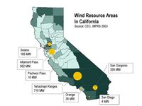
 The San Gorgonio wind farm consists of about 2,500 wind turbines with a capacity of 359 MW and an annual generation of about 893 gigawatt-hours (GWh) of electricity. The San Gorgonio wind resource area is one of three primary regions, the others being Tehachapi Pass and Altamont Pass. Together these three areas account for nearly 95 percent of all commercial wind power generation in California, and approximately 11 percent of the world’s wind-generated electricity. In 2004, wind energy in California produced 4,258 million kilowatt-hours of electricity, about 1.5 percent of the state's total electricity. That's more than enough to light a city the size of San Francisco.
Trends are leaning towards even greater future integration of wind energy into Californian energy markets. The Renewable Portfolio Standards (RPS) require California to receive 20 percent of its power generation from renewable sources. Because California is already realizing the economic and social benefits from wind energy, the state will likely continue to focus on wind energy in order to meet its RPS. The California Energy Commission has estimated a 15 percent increase in new wind energy development. This could lead to a total capacity of 930 MW from the San Gorgonio area by year 2017.
 The San Gorgonio wind farm. Image: NASA
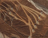
 The image to the image to the right shows wind turbines in the San Gorgonio Pass as captured by the Ikonos satellite on September 14, 2003. The Pass cuts a wide gap through the San Bernardino Mountains to the north and the San Jacinto Mountains to the south. The burnt-orange landscape is dotted with shrubs or small trees. Turbine access roads branch out from numerous “handles” like multi-pronged rakes. The blades of the turbines cast black shadows on the ground. The silvery braided channels of a dry wash weave across the upper right corner of the scene.
Further Reading
California Energy Commission
American Wind Energy Association