Salton Sink
| Topics: |
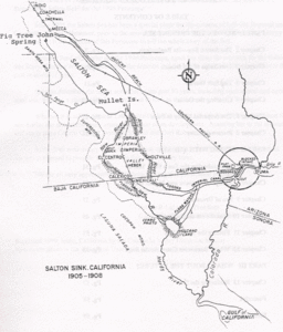 Map of Salton Sink, California. (Image: Laflin, P., 1995. The Salton Sea: California's overlooked treasure. The Periscope, Coachella Valley Historical Society, Indio, California. 61 pp.)
 Salton Sink, Califonia, throughout the Spanish period of California's history, was referred to as the 'Colorado Desert' after the Rio Colorado (Colorado River), or 'red colored river'. In the 1853-55 railroad survey, it was called 'the Valley of the Ancient Lake'. On several old maps from the Library of Congress, it has been labeled 'Cahuilla Valley' (after the local Indian tribe) and 'Cabezon Valley' (after a local Indian leader - Chief Cabezon). 'Salt Creek' is first named on a map in 1867 and 'Salton Station' is on a railroad map from 1900, although this place had been there as a rail stop since the late 1870s. The name 'Salton' appears to be from the fact that they had been mining salt in the area at least as early as 1815. A yearly expedition traveled to the area to mine salt for Los Angeles residents. With the extension of a rail line through the basin, large scale salt mining started in 1884. After that, the general area is referred to as the 'Salton Sink' or the 'Salton Basin' – ‘sink’ or ‘basin’ refering to the natural bowl-type geography of the area. When the Colorado River broke through its levees during the great floods of 1905, the Salton Sink became the Salton Sea.
Further Reading
- Laflin, P., 1995. The Salton Sea: California's overlooked treasure. The Periscope, Coachella Valley Historical Society, Indio, California. 61 pp. (Reprinted in 1999)