St. Lawrence River, Canada
General Description
 (Source: Biodiversity Institute of Ontario)
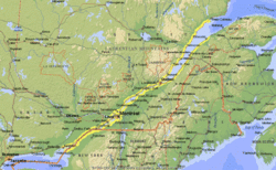
 The St. Lawrence River is among the world's greatest river systems and has the highest annual discharge of any Canadian river at an average of 447 cubic kilometers (km) per year. No other river in the world discharges more water into the Atlantic Ocean, and only the Mississippi River has a greater discharge in North America. The river is the chief outlet of the Great Lakes and travels more than 1200 km. It flows from the northeast end of Lake Ontario past Montreal to Quebec City where it forms the huge Gulf of St. Lawrence estuary. The entire St. Lawrence River System, including the Great Lakes, spans a distance of around 3200 km and drains an area of approximately one million square kilometers.
River Course
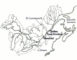 Great Lakes-St. Lawrence system. (Source: Biodiversity Institute of Ontario)
 The river follows a northeast course along a lowland belt between the Adirondack Mountains and Appalachian foothills to the east and the uplands of the Canadian Shield to the west. Belts of resistant rock are exposed in several areas, such as the famous Thousand Islands section. This narrow gulf of Lake Ontario is studded with islands which are known for their tranquil beauty. Further downstream the river narrows and flows through a series of rapids between Prescott and Cornwall. The most famous of these are the Galops and Long Sault – a stretch known as the International Rapids because the New York/Ontario border follows the midline of the river. After this the river enters Lake St. Francis and then moves through a set of three more rapids: Coteau, Cedars and Cascades. It is then joined by two distributaries of the Ottawa River and widens into Lake St. Louis. A final set of rapids occurs as the river narrows and swings eastward at Lachine. These rapids were partly responsible for the growth of Montreal since they mark the natural upstream limit of large boat navigation.
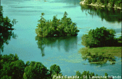 A few of the Thousand Islands. (Source: Biodiversity Institute of Ontario)
 The St. Lawrence flows through the Montreal lowlands until it widens into Lake St. Pierre. The Richelieu and St. Francis tributaries flow in from the east and the St. Maurice River joins from the north at Trois Rivieres. At this point the river has reached sea level and the effects of the Gulf tides begin. At Quebec City the river is 90 metres (m) below the general surface level and over 1.5 kilometres wide, with tides reaching nearly six metres. The strategic defensive positioning of the settlement at these cliffs, combined with it being the natural limit of ocean navigation, led to Quebec City becoming the center of New France. Further downstream the St. Lawrence divides into channels on either side of l'Ile d'Orleans. The Montmorency River joins via a waterfall that is more than 30 m higher than the Niagara Falls. The Laurentide highlands border the river's north shore. Cap Tormente, at 550 m, is the first of a number of promontories that contribute to the magnificent scenery of the shoreline. At this point the river is 16 km wide and the transition from river to gulf is apparent. A bit further, the Saguenay River joins the St. Lawrence through a great fjord framed by the twin capes Eternity and Trinity. The river widens to 40 km and opens out rapidly into the Gulf. The nutrient-rich waters of the estuary support a variety of aquatic fauna, including beluga and blue whales.
History
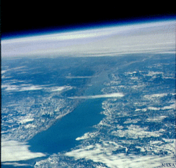 Satellite view looking SW down estuary towards Quebec City. (Source: Photo by NASA)
 Jacques Cartier called it "the River of Canada." It became known as the St. Lawrence after his second voyage in the year 1535 AD, when he landed on August 10th – the Feast of Saint Lawrence. The river has always been important in navigation and was extensively used in the early fur trade. Colonization, the American Revolution and the establishment of Upper and Lower Canada in 1791 all added significance to the identity of the St. Lawrence as a vital route from the Atlantic Ocean into the heart of Canada. The first lock canals in Canada were built around the Coteau and Cascade rapids in the late 1700's to allow the passage of canoes and small boats. In the 1840's, bigger canals were built to accommodate the advent of steamships and the increase in traffic. The opening of the Canadian prairies made the St. Lawrence the greatest grain route in the world. The bottleneck between Montreal and the Great Lakes continued to slow shipping traffic until the completion of a joint Canada-U.S. Seaway project in 1959. The dams and locks of the project were designed to eliminate rapids preventing travel between the Atlantic Ocean and the Great Lakes. The St. Lawrence Seaway-Great Lakes Waterway is now the world's longest inland waterway open to ocean shipping. The dams along the St. Lawrence and its tributaries are also an important source of hydroelectric power. Unfortunately, the extensive modification of the St. Lawrence by such human activities has severely impacted the quality and health of its waters and impacts on wildlife.