Padilla Bay National Estuarine Research Reserve, Washington
Contents
Introduction Padilla Bay Reserve map. (Source: NERRS (Padilla Bay National Estuarine Research Reserve, Washington) )
Padilla Bay is an estuary at the saltwater edge of the large delta of the Skagit River. It is about eight miles long and three miles across. In 1980, this bay was selected to be included in the National Estuarine Research Reserve System.
Because the bay is filled with sediment from the Skagit River, the bottom is very shallow, flat, and muddy. It is so shallow that almost the whole bay is intertidal. This means that it is flooded at high tide. When the tide goes out the whole bay empties out, exposing miles and miles of mud flats. This condition allows unusually large eelgrass meadows to grow. There are nearly 8,000 acres of eelgrass in Padilla Bay (see habitat map).
Eelgrass is valuable because it is habitat for wildlife and commercially harvested animals. Eelgrass is used as a nursery by salmon, crab, perch, and herring. Eelgrass is also home for millions of worms, shrimp, clams, and other invertebrates that are food for great blue herons, eagles, otters, seals, as well as humans. This is why Padilla Bay was selected to be a National Estuarine Research Reserve.
This national system of reserves is administered by the National Oceanic and Atmospheric Administration. Padilla Bay Reserve is managed by the Washington Department of Ecology in the Shorelands and Environmental Assistance Program.
Ecology
Flora (Plant Life)
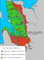 Padilla Bay Reserve habitat map. (Source: Padillabay.gov)
 In underwater eelgrass meadows, tiny phytoplankton (microscopic plants) float in the water and grow on the surface of the mud and seagrasses. In the intertidal and subtidal areas of Padilla Bay, there are vast underwater meadows of seagrasses. These grasses help stabilize the substrate (mud) and provide food and shelter for a great number of estuarine creatures. There are two species of seagrass in Padilla Bay: Zostera marina or eelgrass (native to Padilla Bay) and Zostera japonica (a nonnative species). Red, green and brown algae are found attached to bits of shell buried in the mud or to the seagrasses themselves. Almost all of the salt marsh habitat associated with Padilla Bay was diked and drained before 1900 for farm land. The fringe of salt marshes that remains commonly has salt grass (Distichlis spicata), salt bush (Atriplex patula), pickleweed (Salicornia virginica) and seaside arrowgrass (Triglochin maritimum), among others. There is a nonnative salt marsh plant, Spartina, that is threatening to disrupt native saltwater ecosystems in the Pacific Northwest. Spartina encroaches into salt marsh and mud flat habitats, crowding out native plants and animals. Where there is more freshwater influence, such as along sloughs, plants like Lyngby's sedge and tufted hair grass may be found.
The terrestrial flora around Padilla Bay, aside from the agricultural fields and diked areas, consists of second-growth forests of mixed conifers, broad leaf trees and occasional pastures. Forests are dominated primarily by Douglas-fir, western red cedar, red alder, Pacific madrone and big leaf maple. The understory includes salal, Oregon grape, stinging nettle, Indian plum and ocean spray.
Fauna (Animal Life)
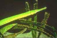 Figure 1. Bay Pipefish (Source: NERRS)
 Marine invertebrates, like the crab, are found abundantly in the bay's eelgrass, mud and sand. Shrimp and crab, especially the Dungeness crab, are of great economic importance. Other invertebrates common to the reserve include the mud snail, Nasarius snail (both of these snails are exotic imports from Japan), mud clam, bent-nosed clam, littleneck clam, Pacific or Japanese oyster (introduced historically for commercial cultivation and more recently for recreational harvest), native oyster (now very rare), burrowing anemone, mud shrimp, tongue or acorn worms, bubbleshell (a snail with the shell covered by a mantle so it looks like a sea slug), nudibranchs, Taylor's sea slugs, ribbon worms, polychaete worms, lug worms, brooding anemone, jellyfish and amphipods. Herring are the bay's most economically-significant fish species. Herring and smelt both use the bay's eelgrass beds for spawning. The bay is also an important migration route for juvenile Chinook, coho, pink and chum salmon (Figure 2). Common flat fish include English sole, Dover sole, rock sole and starry flounder. Other resident fish species include threespine stickleback, gunnels, sculpin and bay pipefish (Figure 1).
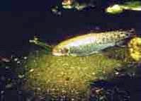 Figure 2. Chum Salmon (Source: NERRS)
 During the winter, the bay contains an average of 50,000 ducks of 26 species. A large colony of great blue heron live in a rookery on Samish Island. While their nesting area is outside the boundaries of the reserve, they feed in both Samish and Padilla Bays. A shorebird called the dunlin is found by the thousands in the reserve. The overall bird index for Padilla Bay area exceeds 240 species making it one of the most diverse areas for birding in the state. Some of the most spectacular residents of Padilla Bay Reserve are the bald eagle, peregrine falcon and nine other species of raptors, including merlins and snowy owls who winter in the area. The flats near Padilla Bay support one of the largest known wintering populations of peregrine falcons in North America.
As for marine mammals, as many as 150 harbor seals have been observed hauled out on the sand islands of Padilla Bay during low tide. River otters have been observed in the Bay as well. Outside the immediate boundary in deeper waters, pods of killer whales have been seen regularly. California sea lions and porpoises are rare visitors. Terrestrial non-marine mammals in the reserve include black tailed deer, raccoon, red fox, coyote, muskrat, beaver, porcupine and long-tailed weasel.
Endangered Species
Padilla Bay Reserve serves as home for the threatened peregrine falcon. Several pairs nest near Padilla and can be seen year-round feeding on smaller birds. The populations of peregrine and other species of falcons increase during the winter because so many shorebirds and other waterfowl winter here.
In recent years, several species of salmon in the Pacific Northwest have been identified as threatened or endangered under the federal Endangered Species Act. Padilla Bay is valuable salmon habitat because of the extensive eelgrass meadows.
Tidal Range and River Flow
Puget Sound tides are mixed semi-diurnal. The two low and high tides are uneven, typically with a very low tide followed by a very high tide, followed by moderate tides. The extreme spring tide daily range in water level is about 12 feet.
The Skagit River which formed the delta mud flats of Padilla Bay no longer enters the bay directly. Some fresh water from the Skagit now enters Padilla Bay from the south through the Swinomish Channel. Several small agricultural sloughs empty into the bay, draining the 23,000-acre watershed. The salinity of Padilla Bay hovers around 28 parts per trillion (ppt) which matches the salinity found in the surrounding Puget Sound/Georgia Basin. The majority of fresh water in the Puget Sound/Georgia Basin comes from the Fraser River in Canada. The Fraser enters the Strait of Georgia about 50 miles north of Padilla Bay.
Soil Types and Geology
Nearly all of the Padilla Bay watershed is made up of alluvial deposits from the Skagit River and glacial till. The exceptions are Hat Island, which is serpentine bedrock and dredge spoil islands.
Puget Sound was carved by continental glaciers containing 2,500 cubic miles of ice. The crushing weight of ice descended on the Puget Sound area two to four times in the last 100,000 years. The massive sheets of ice created valleys, basins and the north-south aligned bays commonly found in the area. The retreat and melting of the last sheet some 12,000 to 20,000 years ago left most of the topographic features of Puget Sound today. Since that time the Skagit River has been quickly filling in the bays it flowed into. Nearly all of the Padilla Bay watershed is made up of alluvial deposits from the Skagit River and glacial till. Saddlebag and Dot islands are bedrock features consisting of serpentinite rock that is over 200 million years old.
Cultural History
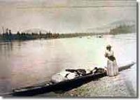 Figure 3. (Source: NERRS)
 Evidence exists of early Native American habitation in the general Padilla Bay-Skagit area for 5,000 years. Several prehistoric sites are found near Padilla Bay but none actually on the bay or bay margin. This is probably due to the extensive diking that occurred in the late 19th and early 20th century. Habitation by Indians elsewhere in Washington can be traced back some 12,000 to 15,000 years. The Noo-Wha-Ah and Swinomish were the primary tribes utilizing the resources of Padilla Bay.
Spanish explorers traveled through Skagit and Padilla Bay in the 1790s and Padilla Bay was named after the Viceroy of Mexico. Many of the islands and landforms in northern Puget Sound were named by the original Spanish explorers.
In the early 1800s many native American tribes were decimated by the diseases brought by trappers, traders and settlers. By the late 1800s many of the surviving native people relocated to the Swinomish Reservation just south of Padilla Bay along the Swinomish Channel. The Swinomish are the closest tribe to Padilla Bay, with their tribal center located in the southwest corner of the Swinomish Channel, adjacent to the town of LaConner. They have traditionally hunted and fished at Padilla Bay for hundreds of years.
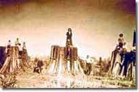 Figure 4. (Source: NERRS)
 The earliest nonnative settlers built log cabins on Fidalgo Island in 1858. In 1867, a trading post was erected on the Swinomish flats at LaConner, and shortly afterwards the agricultural and timber potential of the area was recognized. Also in 1867, a logging camp was established on Samish Island. In 1874 much of the area was served by a regular steamboat service as there were no roads in the area. Land access was limited to horse trails and short wooden plank roads.
Logging operations reached a peak between 1902 and 1909, when one of the state's largest companies bought or leased much of the land surrounding the bay. As settlers purchased and farmed the inexpensive "stump farms" and diking began in earnest, a strong agricultural movement began which thrives to this day. Today, Skagit Valley is one of the most fertile agricultural valleys in the world. It produces 25 percent of the nation's frozen peas and 85 percent of the cabbage and beet seeds. Fishing was and is an important part of the Padilla Bay scene. Crabbing and salmon harvesting occur on the bay's fringes but are not as productive as they were at the turn of the century.
On the western fringe of the reserve, intensive industry is highly evident. March Point harbors two large oil refineries. They refine crude oil into gasoline, stove oil, diesel and other products for use in the Northwest and elsewhere. Their waste waters are treated and the few minor spills they have experienced have been cleaned up without apparent impact. Near the highway at the southern end of the bay are fertilizer, seed and feed processing facilities that service the large agricultural valley.
Partners and Supporters
The reserve's parent agency is the Washington State Department of Ecology. The Padilla Bay Foundation supports the reserve, and the research program works closely with the University of Washington and Western Washington University. Stewardship partners include Skagit Valley College; Skagit Conservation District; and many local, state, federal and tribal resource agencies and personnel.
Further Reading
| Disclaimer: This article is taken wholly from, or contains information that was originally published by, the National Oceanic and Atmospheric Administration. Topic editors and authors for the Encyclopedia of Earth may have edited its content or added new information. The use of information from the National Oceanic and Atmospheric Administration should not be construed as support for or endorsement by that organization for any new information added by EoE personnel, or for any editing of the original content. |