Orinoco Delta swamp forests
Introduction The Orinoco Delta Swamp Forests occur in a diverse and porous matrix of coastal (Orinoco Delta swamp forests) vegetation types along the river delta and surrounding regions of northwestern Venezuela and northeastern Guyana. These inundated forests have moderate species richness, and provide habitat to a number of endangered and endemic species. Much of this region is still intact due to its inaccessibility and poor soils, however recently oil exploration and extraction projects have encroached into these once pristine forests.
Location and General Description
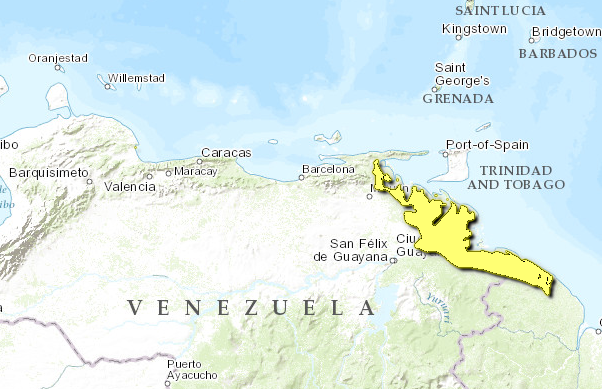
The Orinoco Delta Swamp Forests ecoregion occurs in a continuous expanse from the southern reaches of the Paria Peninsula in northern Venezuela, extending southwards along the coastal floodplains of the Orinoco Delta to the Waini River in Guyana. The western and northern boundaries and are delineated by mangroves and the Atlantic Ocean, while the eastern boundary occurs along a precipitation gradient - bordering xeric scrub and scrublands in the north, llanos and wetlands in the central portions, and moist forests in the south.
Climate in this region is tropical, hot and humid. Precipitation varies throughout the region, and fluctuates between 500-2,000 millimeters (mm) annually, becoming increasingly wetter and more humid moving south. Rainfall is irregular and the wet season begins in April/May and usually lasts through December. Temperatures average 26 °C, becoming slightly cooler at night.
Geographically this is a landscape of little relief. Elevations typically average one meter (m), but reach as high as 9 meters in the highest terra firma levies south of the delta region. The soils in this ecoregion are almost entirely alluvial deposits, originating as far away as the northern Andes of Colombia and Venezuela.
These swamp forests are characteristically impregnated with river systems and hosts a great diversity of riparian features including permanent wetlands and marshes (Orinoco wetlands ecoregion), large rivers, oxbows, lakes, small gallery streams, levees, and the typical delta alluvial fan. The delta itself consists of increasingly partitioned distributions which become more confined and disjunct as they diverge from the main channel, then come together again as they move east towards the Atlantic Ocean. In so doing these numerous rivers form a great number of islands.
This swamp forest ecoregion is heavily influenced by, and in some areas characterized by the local river systems - particularly in the Orinoco Delta region. According to the broad vegetation classification of UNESCO, the core of this ecoregion falls under the classification of tropical ombrophilous swamp forest. The predominant vegetation in this region are hydrophilous trees and palms, with abundant epiphytes and scattered herbaceous layer. Hardwood trees include Carapa guianensis, Ceiba pentandra, Dimorphandra excelsa, Hirtella triandra, Inga punctata, Mainilkara globosa, Ocotea rodioei, Pentaclethera filamentosa, Pterocarpus officinalis, Symphonia globulifera, and Terminalia obovate. Numerous palms occur here as well, and often in monotypic stands. These include Astrocaryum aculeatum, Euterpe oleraceae, Manicaria succifera, and Mauritia flexousa.
Biodiversity Features
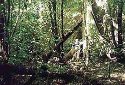
 Near Canyo Colorado, Venezuela. (Photograph by J. van der Woude) The swamp forests of the Orinoco (Amacuro) Delta are important wildlife [[habitat]s] and are known to support a number of endemic plant species. Swamp forests are the dominant vegetation feature of the Orinoco Delta, and the ecoregion is embedded in a complex matrix of wetlands, mangroves, and both inundated and terra firma moist forest. These swamp forests are characterized by permanently inundated forests and abundant waterways and canals.
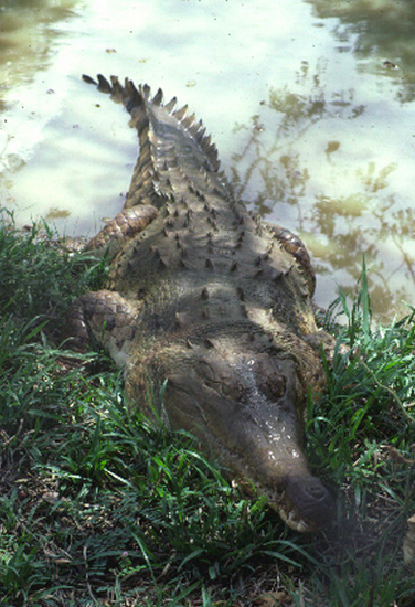
These swamp forests provide important habitat for a number of threatened and endangered species such as the Orinoco crocodile (Crocodylius intermedius CR), Amazon river dolphin (Inia geogffrensis VU), jaguar (Panthera onca LR), bush dog (Speothos venaticus VU), giant river otter (Pteronura brasiliensis EN), Orinoco goose (Neochen jubata LR), and the harpy eagle (Harpia harpyja LR).
Current Status
The swamp forests of eastern Venezuela are, as a whole, relatively intact. Heavy regional exploitation is a threat in the northern areas where population pressures are higher. Three protected areas exist which protect portions of this ecoregion, two national parks and one forest reserve. Two indigenous areas also occur, but offer lesser protection and are readily exploited.
The following protected areas include portions of this ecoregion but also include sections of the surrounding ecoregions: the Guianan mangroves, Guianan moist forests, and the Orinoco wetlands. The Delta del Orinoco biosphere reserve (9¸21'N - 60¸56'W) was gazetted in 1991 by WCMC & UNEP, and is the largest protected area within the delta region. This national biosphere reserve has been given IUCN category VI status and covers an area of 876,500 ha - only portions of which are represented by this wetlands ecoregion. The Delta del Orinoco National Park (9¸25'N - 61¸30'W), gazetted in 1992, also offers protection and with increasing levels of enforcement. This national park is given IUCN Category II status and covers an area of 331,000 hectares (ha).
The Imataca Forest Reserve (8¸20'00N - 59¸55'00W), gazetted in 1961, has been given an IUCN Category VI status, and encompasses these swamp forests south of the Orinoco River. This 3,203,250 ha reserve is among the largest in Venezuela - however this ecoregion is only represented in its eastern coastal portions. Turuïpano National Park (10¸34'N - 62¸43'W), gazetted in 1991 protects portions of the northern extent of this ecoregion. This 72,600 ha park is given an IUCN Category II status. Finally, Mariusa National Park (9¸30'00N - 61¸30'00W ) along the northern coastal delta offers protection to some of the smaller outliers of this ecoregion, especially along the Maracao River. This 265000 ha park has an IUCN category II status was gazetted in 1991.
Types and Severity of Threats
The greatest threat to this region is currently oil exploration and extraction, which posses a serious threat to much of the Orinoco Delta and surrounding regions. The threats imposed by oil extraction are multifaceted, and begins with the exploration phases which opens up the area. Once extraction begins settlement and human population pressures increase, which have the effect of increasing hunting, small scale forest clearing for subsistence and materials, and displacement and corruption of the indigenous Warao peoples.
Secondarily is water diversion and containment, which disrupts the seasonal cycles of the Orinoco River and its tributaries. Portions of this wetland ecoregion have been severely altered as a consequence of a flood control program initiated in the 1960s when the Caño Mánamo was dammed. The reduced water levels in the upper delta have caused the region to become tidal, and as a result the water levels now rise and fall by 1-2m daily. This has also caused the salinity levels to increase dramatically which has in turn influenced the flora and fauna which are able to survive in these swamp forests as well as the surrounding [[river]s] and tributaries.
Palm exploitation is a major problem in some areas, and commercially used species such as Euterpe oleraceae and Mauritia flexuosa are often heavily exploited in the more accessible regions. Timber extraction potential is poor, however threats from this resource exploitation are compounded by the important role the target species play in maintaining the fragile ecosystems. Soil quality is also poor and does not support agriculture.
Logging is becoming a growing concern.
Justification of Ecoregion Delineation
These seasonally inundated forests occur from the Araya-Paria delta and extend southwards along Atlantic Venezuela, across the Orinoco delta, and into northern Guyana. These forests are distinct in their vegetation, which is adapted to seasonal and permanent inundation – and several endemic species are present. Eastern linework follows the transition from coastal mangrove to moist forest, and is interspersed with permanent and seasonal open and semi-open wetlands. Within Venezuela, linework follows Huber and Alarcon classification of the "delta lowland and coastal swamp" subregion (B.3). Portions extending into Guyana roughly follow the Huber et al. classification of "low, evergreen, seasonal flooded swamp and marsh forest".
Additional Information on this Ecoregion
- For a shorter summary of this entry, see the WWF WildWorld profile of this ecoregion.
- To see the species that live in this ecoregion, including images and threat levels, see the WWF Wildfinder description of this ecoregion.
- World Wildlife Fund Homepage
Further Reading
- Dinerstein, E., D. M. Olson, D. L. Graham, A. L. Webster, S. A. Primm, M. P. Bookbinder, andG. Ledec. 1995. A conservation assessment of the terrestrial ecoregions of Latin America and the Caribbean. DC.: WWF and The World Bank.
- Eisenberg, J. 1989. Mammals of the Neotropics Volume 1: the northern Neotropics. University of Chicago Press, Chicago. ISBN: 0226195392
- Huber, O., G. Gharbarran, and V. Funk. 1995. Vegetation map of Guyana (preliminary version). 1:1,000,000. Centre for the Study of Biological Diversity, University of Guyana, Georgetown, Guyana.
- Huber, O., and C. Alarcon. 1988. Mapa de vegetación de Venezuela. 1:2,000,000. Ministerio del Ambiente y de los Recursos Naturales Renovables, Caracas, Venezuela.
- IUCN. 1996. The Conservation Atlas of Tropical Forests: the Americas. Harcourt, C.S. and J.A. Sayer, editors. Simon and Schuster, New York. ISBN: 0133408868
- IUCN Red List Database. 2000. (http://www.redlist.org).
- UNEP/WCMC Protected Areas database (http://www.unep-wcmc.org).
- World Bank. 1998. The Imataca Forest Reserve and Environs: issues in resource planning, public participation, and sustainable management. World Bank. P. 35.
| Disclaimer: This article is taken wholly from, or contains information that was originally published by, the World Wildlife Fund. Topic editors and authors for the Encyclopedia of Earth may have edited its content or added new information. The use of information from the World Wildlife Fund should not be construed as support for or endorsement by that organization for any new information added by EoE personnel, or for any editing of the original content. |

