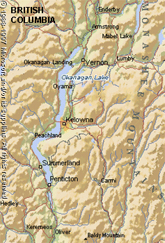
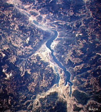
Okanagan Lake, British Columbia
Physical Attributes
 (Source: Biodiversity Institute of Ontario)
 Altitude: 342 meters above mean sea level
Surface Area: approximately 450 sq. km
Mean Depth: 76 m
Maximum Depth: 230 m
Volume: approximately 34 cu. km
Shoreline Length: 270 km
Drainage Basin: 6187.5 sq km
General Description
 (Source: Biodiversity Institute of Ontario)
 Okanagan Lake is located in south-central British Columbia and is the largest of the five main interconnected lakes in the Okanagan Valley. Vernon Creek joins this lake to Kalmaka Lake, which is the main source of its water. Water empties out of the southern end of Lake Okanagan into the Okanagan River, which flows through into Lakes Skaha, Vaseaux and Osoyoos to join the Columbia Riverfurther south. Although the offshore regions of the lake are oligotrophic, the shallower parts have poor water circulation, higher nutrient levels and plankton blooms. The entire lake completely frozen three or four times in the past century and consequently is monomictic most years.
Watershed
The U-shaped Okanagan Valley has mountains with heights of 1000-2500 m rising on either side. The floor of the valley is covered with unconsolidated glacial deposits and at the south end, terraces were formed due to the repeated arrest of lowered water levels in postglacial lakes. The terraces are used for intensive agriculture - particularly fruit trees and grape growing. Other important economic activities include forestry, copper mining and tourism. Vernon, Kelowna and Penticton are three cities found along the lakeshore. Hazards to the Lake Okanagan ecosystem include log booms, agricultural pesticides (including herbicides), as well as nitrate and phosphorus from sewage treatment.