Northern Marianna Islands
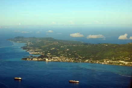
Aerial view of Saipan, Northern Mariana Islands. Source: P. Miller/Wikimedia Commons
Countries and Regions of the World Collection  The Northern Marianna Islands consists of 14 islands including Saipan, Rota, and Tinian with about 44,500 people in the North Pacific Ocean, about three-quarters of the way from Hawaii to the Philippines. They are a seklf-governing commonwealth in political union with the United States.
The Marianna Islands are composed of the Northern Marianna Islands and Guam, which lies at the south end of the island chain. A classic example of a volcanic island arc, the Mariana Islands extend about 900 kilometers (km) north-south along the edge of the Mariana Trench in western Micronesia.

Its major environmental issues include:
- contamination of groundwater on Saipan may contribute to disease;
- clean-up of landfill; and,
- protection of endangered species conflicts with development
There are active volcanoes on Pagan and Agrihan.
Under US administration as part of the UN Trust Territory of the Pacific, the people of the Northern Mariana Islands decided in the 1970s not to seek independence but instead to forge closer links with the US. Negotiations for territorial status began in 1972. A covenant to establish a commonwealth in political union with the US was approved in 1975, and came into force on 24 March 1976. A new government and constitution went into effect in 1978.
Contents
Geography
Location: Oceania, islands in the North Pacific Ocean, about three-quarters of the way from Hawaii to the Philippines
Geographic Coordinates: 15 12 N, 145 45 E
Area: 464 sq km. Note: consists of 14 islands including Saipan, Rota, and Tinian
|
|
|
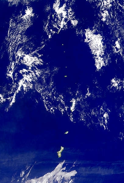
Source: NASA.Provided by the SeaWiFS Project, NASA/Goddard Space Flight Center, and ORBIMAGE |
|
|
|
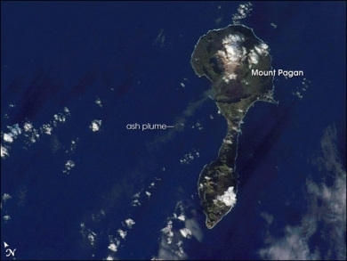
Mount Pagan. this astronaut photograph records volcanic activity on January 11, 2007, that produced a thin plume that extended westwards away from Mount Pagan. The plume was most probably steam, possibly with minor ash content. The island is sparsely populated, and it is monitored for volcanic activity by the United States Geological Survey and the Commonwealth of the Mariana Islands. Source: NASA. Astronaut photograph ISS014-E-11872 was acquired January 11, 2007, |
Coastline: 1,482 km
Maritime Claims:
Natural Hazards: active volcanoes on Pagan and Agrihan; typhoons (especially August to November)
Terrain: southern islands are limestone with level terraces and fringing coral reefs; northern islands are volcanic The highest point is an unnamed elevation on Agrihan (965 m).
Climate: tropical marine; moderated by northeast trade winds, little seasonal temperature variation; dry season December to June, rainy season July to October
Volcanism
The Mariana Islands are part a volcanic island arc—surface volcanoes formed from magma generated as one tectonic plate overrides another. In the case of the Mariana Islands, the Pacific Plate is being pulled, or subducted, beneath the Philippine Plate along the famously deep Mariana Trench, which is more than 11 kilometers (nearly 7 miles) below sea level. Pagan Island (image right) is made up of two volcanoes connected by a narrow isthmus of land. The volcanoes are stratovolcanoes, which are tall, typically cone-shaped structures formed by layers of dense, crystallized lava and less-dense ash and pumice. Mount Pagan, the larger of the two volcanoes, forms the northeastern portion of the island and has been the most active historically.
The most recent major eruption took place in 1981, but since then numerous steam- and ash-producing events have been observed at the volcano—the latest reported one occurring between December 5–8, 2006.
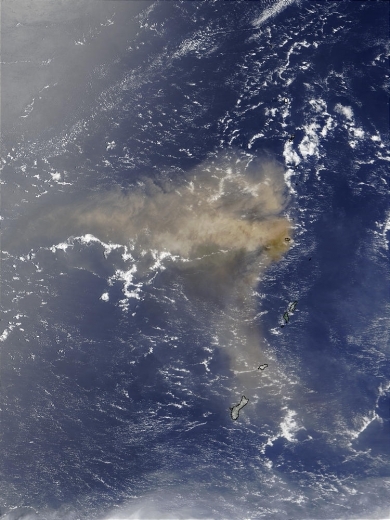
On May 10, 2003, the Anatahan Volcano in the Northern Mariana Islands announced its presence with the eruption of a huge plume of volcanic ash that spread hundreds of miles across the Pacific Ocean. This is the first documented eruption of this volcano, which is on the island of the same name. The island is only 9 kilometers long and is made up of two volcanoes that are slowly coalescing.
Ecology and Biodiversity
Ecologically, the Marianna Islands are included with the Marianas tropical dry forests ecoregion.
The islands can be divided into two distinct groups: the northern, geologically young islands still have some active volcanism; the older southern islands are composed of elevated coral limestone and older weathered volcanic sequences.
The islands of the northern group are dominated by primary grasslands, and show little human disturbance; those in the southern group have been heavily disturbed and are now mostly covered with secondary forest. Throughout the islands, there is a fairly low diversity of flora with probably no more than 500 species, including both native and naturalized plants.
Because of recent volcanism, there is little forest on the nine main islands of the northern Marianas. On older, gently sloping rough lava flows, there are occasional patches of mixed-species forests. The indigenous ironwood tree, Casuarina equisetifolia, locally known as gagu, is one of first tree species to colonize lava flows, along with a fern species, Nephrolepsis hirsutula. On the four smaller islands, which have no goat grazing, patches of forest dominated by Pisonia grandis can be found.
Remnants of a mixed broadleaf forest (Aglaia-Elaeocarpus) exist on the four larger islands of Agrihan, Pagan, Sarigan, and Anatahan. Two key species in this forest type are the mapunyao (Aglaia mariannensis), an understory tree endemic to the Mariana Islands, and the yonga (Elaeocarpus joga) which is endemic to Micronesia. The mapunyao is found in the forest understory on most of the islands because it can grow on either limestone or volcanic soils. The yonga is usually a large tree with a spreading crown, although in the Marianas it is usually stunted by typhoons and reaches heights of only about 15 meters (m). This tree has a bright blue berry which is a favorite food of birds, especially fruit doves. Obha considers the Aglaia-Elaeocarpus forest type to be the upland climax forest for the larger Northern Mariana Islands.
Asuncion has been more thoroughly studied than many of the other islands in the northern group. A steep volcanic cone 891 m in elevation, it last erupted in 1906, but active fumaroles were observed as recently as 1996. The most extensive forest type on this currently uninhabited island is a scrubby, mixed-broadleaf forest dominated by Terminalia spp. These deciduous, indigenous trees have edible kernels that may have been favored by early human inhabitants. The seed of the tree is dispersed by fruit bats which feed on the husk. Terminalia is found on the southern slopes of Asuncion above the coconut groves and on lower slopes around the western side of the island. It appears to be the best developed native forest type currently occurring in the chain north of Saipan. Other woody plants found both in the forest and in adjacent ravines and coastal thickets include Pandanus, Premna, Pisonia, Neisosperma, Trema, Ficus, Pipturus, Erythrina, and Hibiscus tiliaceus.
Asuncion is home to approximately 400 endemic Mariana flying fox (Pteropus mariannus), and 25 bird species, including the Micronesian starling (Aplonis opaca) and the Micronesian honeyeater (Myzomela rubrata).
Humans have had a major influence on the ecosystems of the Mariana Islands for at least 3,500 years. Over time, a general clearing (Deforestation) and burning of forests on volcanic soils has created either secondary forest or savanna. This has caused soil erosion and loss of nutrients after frequent heavy rains. In areas of limestone soils, which are more fertile than volcanic soils, the forests were cleared for coconut plantations, fields, and gardens. A major forest species, Intsia bijuga, has been mostly logged out. A great deal of habitat was also destroyed or altered during World War II. Abandoned cleared land reverts to a tangled secondary growth, dominated by introduced woody plants such as Triphasia trifolia, Jatropha gossypifolia, Pithecellobium dulce, Muntingia calabura, Cananga odorata, and especially Leucaena leucocephala.
A major threat to birds is the potential spread of the introduced brown tree snake (Boiga irregularis), an Australasian native, from Guam to the other Marianas islands. Also, the introduction of the black drongo (Dicrurus macrocercus), a passerine bird native to Africa, Asia, and Australia, has been implicated in the rapid decline of the Rota bridled white-eye (Zosterops rotensis). Cattle, pigs, and goats represent a threat to native vegetation, and there is little available information about the introduced Philippine deer in the Marianas.
|
|
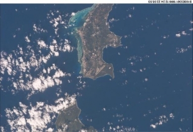
| A view of two of the Mariana Islands as seen from the space shuttle - Saipan (to the north) and Tinian. |
|
|
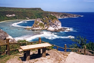
| Bird Island Lookout at the north end of Saipan. |
|
|
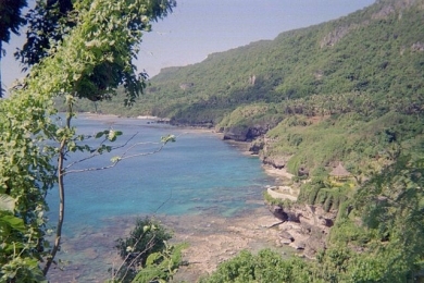
| Rota Island in the Commonwealth of Northern Mariana Islands. Source: CP Snow/Wikimedia Commons. |
|
|
|
On May 10, 2003, the Anatahan Volcano in the Northern Mariana Islands announced its presence with the eruption of a huge plume of volcanic ash that spread hundreds of miles across the Pacific Ocean. This is the first documented eruption of this volcano, which is on the island of the same name. The island is only 9 kilometers long and is made up of two volcanoes that are slowly coalescing. This image of the ash plume was captured on May 11, 2003, by the Moderate Resolution Imaging Spectroradiometer (MODIS) on the Terra satellite. Source: NASA. Credit: Jacques Descloitres, MODIS Rapid Response Team, NASA/GSFC |
People and Society
Population: 44,582 (July 2012 est.)
Ethnic Groups: Asian 56.3%, Pacific islander 36.3%, Caucasian 1.8%, other 0.8%, mixed 4.8% (2000 census)
Age Structure:
0-14 years: 26% (male 6,349/female 5,625)
15-64 years: 70.4% (male 15,014/female 17,397)
65 years and over: 3.6% (male 790/female 875) (2011 est.)
Population Growth Rate: -2.449% (2012 est.)
Birthrate: 20.21 births/1,000 population (2012 est.)
Death Rate: 3.39 deaths/1,000 population (July 2012 est.)
Net Migration Rate: -41.32 migrant(s)/1,000 population (2012 est.)
Life Expectancy at Birth: 77.27 years
male: 74.62 years
female: 80.07 years (2012 est.)
Total Fertility Rate: 2.09 children born/woman (2012 est.)
Languages: Philippine languages 24.4%, Chinese 23.4%, Chamorro 22.4%, English 10.8%, other Pacific island languages 9.5%, other 9.6% (2000 census)
Literacy (age 15 and over can read and write): 97% (1980 est.)
Urbanization: 91% of total population (2010) growing at an annual rate of change of 1.7% (2010-15 est.)
Government
Dependency Status: commonwealth in political union with the US; federal funds to the Commonwealth administered by the US Department of the Interior, Office of Insular Affairs.
Government Type: commonwealth; self-governing with locally elected governor, lieutenant governor, and legislature
Capital: Saipan
Administrative divisions: there are no first-order administrative divisions as defined by the US Government, but there are four municipalities at the second order: Northern Islands, Rota, Saipan, Tinian
Legal System: US system applies, except for customs, wages, immigration laws, and taxation.
Agriculture
Agricultural products: vegetables and melons, fruits and nuts; ornamental plants; livestock, poultry and eggs; fish and aquaculture products
Irrigated Land: 1 sq km (2008)
Resources
Natural Resources: arable land, fish
Land Use:
arable land: 13.04%
permanent crops: 4.35%
other: 82.61% (2005)
Economy
The economy benefits substantially from financial assistance from the US. The rate of funding has declined as locally generated government revenues have grown.
The key tourist industry employs about 50% of the work force and accounts for roughly one-fourth of GDP. Japanese tourists predominate. Annual tourist entries have exceeded one-half million in recent years, but financial difficulties in Japan have caused a temporary slowdown.
The agricultural sector is made up of cattle ranches and small farms producing coconuts, breadfruit, tomatoes, and melons.
Garment production is by far the most important industry with the employment of 17,500 mostly Chinese workers and sizable shipments to the US under duty and quota exemptions.
GDP: (Purchasing Power Parity): $900 million (2000 est.)
GDP: (Official Exchange Rate): $633.4 million (2000)
GDP- per capita (PPP): $12,500 (2000 est.)
Industries: banking, construction, fishing, garment, tourism, handicrafts
Currency: US dollar