Northern tall grasslands
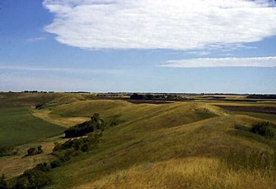
Dahlen Esker, Grand Forks Co., North Dakota, USA Photograph by J.P. Bluemle / North Dakota Geological Survey
The Northern Tall Grasslands is the northernmost extension of the true tallgrass prairie in North America. It follows the Red River Valley from Lake Manitoba in Manitoba south into eastern North Dakota and western Minnesota.
The Northern Tall Grasslands can be distinguished from the mixed grasslands to the west by the dominance of tallgrass species–a feature once relatively uniform across its range–and by the highest levels of rainfall (100 centimeters (cm)/year). This ecoregion is one of the warmest and most humid regions in the Canadian prairies with an annual temperature of around 2.5°C. Mean summer temperatures are 16°C and the mean winter temperature is -12.5°C. Mean annual precipitation ranges from 450-700 millimeters (mm).

Biological Distinctiveness
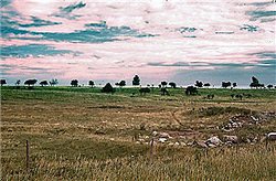 Near Lankin, North Dakota, USA. (Photograph by J.P. Bluemle / North Dakota Geological Survey)
 As in the other tallgrass [[ecoregion]s], the dominant grass species in this ecoregion are big bluestem (Andropogon gerardii), switchgrass (Panicum virgatum) and Indian grass (Sorghastrum nutans). The richness of the herbaceous cover is less than in the other two tall grasslands. The ecoregion is transitional between the aspen (Populus spp.) parkland to the north and northwest, mixed grass prairie to the west and prairie-forest transitional ecoregions to the east. The tallgrass prairie is most dominant on well-drained, drier sites and is often mixed with quaking aspen (Populus tremuloides) and oak (Quercus macrocarpa) groves, and rough fescue grasslands.
Like other ecoregions of this section of North America, bison (Bison bison) and elk (Cervus elaphus) once roamed these tallgrass [[prairie]s], where they were hunted by the coyote (Canis latrans). These species are now gone, although bison are slowly being reintroduced to the area and wolves (Canis lupus) occasionally enter the ecoregion from the east. Common wildlife species in this ecoregion include white-tailed deer (Odocoileus virginianus), rabbit (Sylvilagus spp.), ground squirrel (Spermophilus spp.) and significant waterfowl populations.
This is the northernmost grassland-savanna complex in eastern North America.
Conservation Status
Habitat Loss and Degradation
Approximately 5 percent of the ecoregion remains as intact habitat, mostly on former beach ridge sites that are comprised of coarse sands, droughty and less valuable for crop production, and along riparian corridors. Habitat loss is extensive in this ecoregion given the high rate of conversion to agriculture. More than 75 percent of the ecoregion is considered to be heavily altered.
Remaining Blocks of Intact Habitat
The following blocks of habitat remain in the Northern Tall Grasslands:
- Manitoba Tall Grass Prairie Preserve - southern Manitoba - an area 20 square kilometers (km2) and highly fragmented.
- Agassiz Beach Ridges - northwestern Minnesota - highly fragmented glacial lake ridges comprising an area of 159 km2
- Sheyenne Delta - southeastern North Dakota - stabilized sand dunes in an area about 465 km2
- Delta Marsh - southern Manitoba
- Shilo Military Reservation - southern Manitoba
- Caribou/Beaches Parklands - northern Minnesota - 356 km2 - mostly contiguous area immediately sourth of the Tolstoi/Gardenton Prairie
Degree of Fragmentation
Remaining blocks of habitat are highly fragmented. Most of the remaining habitat blocks are separated by agricultural lands and a relatively dense network of roads.
Degree of Protection
Only parts of the remaining fragments are under some form of conservation management.
- The Tolstoi Prairies are about 50 percent protected
- The Agazzi Ridge about 30 percent protected
- The Sheyenne Delta is about 70 percent public owned, but heavily grazed.
- and many smaller TNC properties in Minnesota and North Dakota
Types and Severity of Threats
The major threat for the ecorgegion is inappropriate management of lands with biodiversity value. Agricultural conversion of native habitat and development pressures continue. Noteworthy threats include: potato farming in the Sheyenne Delta, mining in the Lake Agassiz beach ridges and dunes, and drainage of moist prairie wetlands throughout.
Suite of Priority Activities to Enhance Biodiversity Conservation
- The Shilo Military Reservation contains 48 km2 of mixed grass prairie and supports over 200 plant species. It is a former International Biological Program site. Ensure future protection of this important site.
- The Delta Marsh is an important waterfowl stopover area and the site of intensive research. Piping plovers nest on the beach. Upgrade the protection status of this important site.
- Reduce habitat fragmentation in areas where habitat blocks remain.
- Restore fire cycles in prairie management.
- Secure more land as protected areas, including reviews of existing conservation and wildlife management areas to determine where protection standards need to be increased to prohibit inappropriate activities and further habitat conversion.
- Establish community pastures and public grazing lands where natural vegetation is maintained.
Conservation Partners
- Brandon Naturalists’ Society
- Critical Wildlife Habitat Program
- Ducks Unlimited Canada
- Endangered Spaces Campaign - Manitoba
- The International Coalition
- Manitoba Heritage Habitat Corporation
- Manitoba Naturalists Society
- Minnesota Department Of Natural Resources
- The Nature Conservancy
- The Nature Conservancy - Midwest Regional Office
- The Nature Conservancy of Canada
- The Nature Conservancy, Manitoba
- Red River Basin Water Management Consortium
- Resource Conservation Manitoba
- Sierra Club
- TREE (Time to Respect the Earth’s Ecosystems)
- U.S. Forest Service, Region 3
- U.S. Forest Service, Region 6
- The Wildlife Society
- World Wildlife Fund Canada
Relationship to Other Classification Schemes
Tallgrass prairie is derived from Sims. It corresponds to Küchler unit no. 66 (Bluestem Prairie), and Omernik ecoregion 48 (Red River Valley). The tallgrass prairie defined above corresponds to Bailey as section 251A (Red River Valley section).
This ecoregion corresponds to the Lake Manitoba Plain terrestrial ecoregion (TEC 162). Aspen-Oak Boreal forest (16) and Grassland identify this region.
| Disclaimer: This article is taken wholly from, or contains information that was originally published by, the World Wildlife Fund. Topic editors and authors for the Encyclopedia of Earth may have edited its content or added new information. The use of information from the World Wildlife Fund should not be construed as support for or endorsement by that organization for any new information added by EoE personnel, or for any editing of the original content. |