Northeast Siberian coastal tundra
Tabor Weather Station, Sakha Republic, Russia. (Photograph by John Lamoreux)
Location and General Description
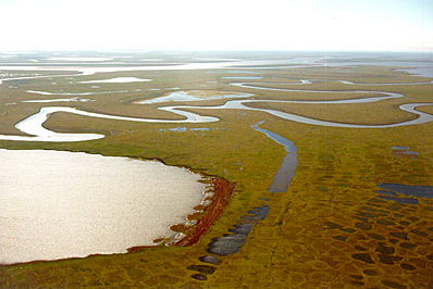
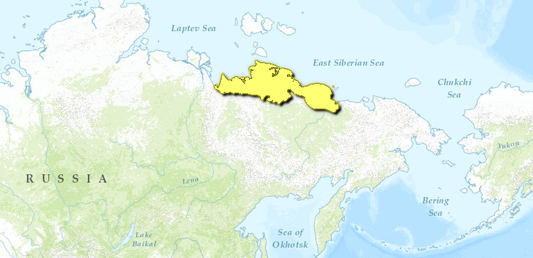
Located along the coast of the Eastern Siberian and Laptev Seas, this stretch of coastal subarctic tundra between the Yana and Kolyma Rivers is some of the most productive arctic tundra wetland areas in northeastern Russia.
The climate of the area is under the influence of both ocean and continental processes. The geology of the area is described as being within the Kimmerian folding zone of the Pacific Ocean Geosyncline. Rocks of the area are volcanic in origin and can be dated to the Cretaceous Period. Tectonically the area belongs to the East Siberian territory of Mesozoic folding. Quaternary sediments consist of layered loamy soils, sandy, and peat deposits. Major river systems, from west to east, include the Yana, Khroma, Indigirka, Alazeya, and Kolyma rivers. The topography is flat and rolling tundra.
 WWF Vegetative characteristics of the region are typical for dwarf shrub arctic and typical tundra, but some sparse patches of larch forest are present along the southern border of the region. Permafrost underlies the entire region and plays a large role in landscape formation and botanical distribution. Common plant species include cotton grass (Eriophorum sp.), sedges (Carex sp.), dryas (Dryas punctata), willows (Salix sp.), crowberry (Empetrum sp.), cranberry (Vaccinium vitis-idea), and mosses.
Biodiversity Features
%2c_north_of_Tabor%2c_Sakha_Republic%2c_Russia.jpg) Long tailed jaeger (Stercorarius longicaudus), north of Tabor, Sakha Republic, Russia. (Photograph by John Lamoreux)
Long tailed jaeger (Stercorarius longicaudus), north of Tabor, Sakha Republic, Russia. (Photograph by John Lamoreux) These tundra [[region]s] are favored by numerous species of birds that migrate along Nearctic and Palearctic flyways to breed here. The large river deltas are some of the most important breeding areas and host between 40 and 60 breeding species each summer. The area between the Yana and Indigirka rivers is the breeding ground for a large majority of the world’s population of Steller’s and spectacled eiders (Polysticta stelleri and Somateria fischeri); both listed in the Red Data Books of Russia and listed as threatened on the U.S. Endangered Species List. Other characteristic birds for this region are red-throated loon (Gavia stellata), black brant (Branta bernicla), curlew sandpiper (Calidris ferruginea), sharp-tailed sandpiper (Calidris acuminata), broad-billed sandpiper (Limicola falcinellus), Ross’ gull (Rhodostethia rosea), ruff (Philomachus pugnax), willow ptarmigan (Lagopus lagopus), and snow bunting (Plectrophenax nivalis).
Current Status
Coastal areas of the Kolyma River Delta, Indigirka River Delta, Khromskaya Bay, and the Yana River Delta are protected within existing reserves and within the Kytalyk Reserve, established in 1996 (25,000 kilometers2 (km)2). There is concern about the release of contaminants from mining operations further upstream that might harm the breeding areas for the birds of this tundra region, but quantitative data is lacking.
The coastal areas of this region are some of the least explored and mapped areas of the world. Even though data gathering projects have recorded information on more than 2000 different species of plants, invertebrates and fish, data coverage throughout the Siberian Arctic, especially in the eastern portions, are still fragmentary. The Siberian north coast area is among the least populated by humans in the world.
Types and Severity of Threats
%2c_near_Tabor%2c_Sakha_Republic%2c_Russia.jpg) Reindeer (Rangifer tarandus), near Tabor, Sakha Republic, Russia. (Photograph by John Lamoreux)
Reindeer (Rangifer tarandus), near Tabor, Sakha Republic, Russia. (Photograph by John Lamoreux) The northern coast of the Russian arctic is an attractive northern shipping route to connect European and Asian ports. Less than 60% of the length of the 11,400 nm Suez Canal, the route is generating increasing interest, especially since Russian arctic areas may hold reserves of oil, gas and other natural resources which could be exported by sea. While the International Northern Sea Route Programme has identified ecologically vulnerable areas along the NSR and concluded that areas of special importance to biodiversity and local indigenous peoples can largely be avoided, the Programme did identify 92 areas that are highly vulnerable to oil spills. According Newell, gold mining and the operation of a tin combine on the Khroma River has destroyed fisheries and transformed habitat within this region.
Justification of Ecoregion Delineation
This ecoregion is a narrow strip of tundra on the coast of the East Siberian Sea extending east of the Lena Delta to the marshy lowland at the mouth of the Kolyma River. Mapped ecoregion boundaries correspond to the montane and lowland tundra distributed between the Laptev and Chukote Seas in Kurnaev’s forest map of the USSR.
Additional information on this ecoregion
- For a shorter summary of this entry, see the WWF WildWorld profile of this ecoregion.
- To see the species that live in this ecoregion, including images and threat levels, see the WWF Wildfinder description of this ecoregion.
- World Wildlife Fund Homepage
Further Reading
- Kurnaev, S. 1990. Forest regionalization of the USSR (1:16,000,000) Moscow: Dept. of Geodesy and Cartography.
- Goryachkin, S.V., R.I. Zlotin, and G.M. Tertitsky. 1994. Russian-Swedish Expedition "Tundra Ecology-94": Diversity of natural ecosystems in the Russian Arctic, A guidebook.
- Nalivkin, D. V. 1960. The geology of the U.S.S.R. A short outline. Pergamon Press. Oxford, U.K. ASIN B000HL1ME0.
- Newell et al. 2000. Friends of the Earth Japan. (www.sirius.com/~meganf/yakutia.html).
- Pearce, J.M., D. Esler, and A.G. Degtyarev. 1998a. Nesting ecology of spectacled eiders (Somateria fischeri) on the Indigirka River Delta, Russia. Wildfowl 49:110-123.
- Pearce, J.M., D. Esler, and A.G. Degtyarev. 1998b. Birds of the Indigirka River Delta, Russia: Historical and biogeographic comparisons. Arctic 51:361-370.
| Disclaimer: This article is taken wholly from, or contains information that was originally published by, the World Wildlife Fund. Topic editors and authors for the Encyclopedia of Earth may have edited its content or added new information. The use of information from the World Wildlife Fund should not be construed as support for or endorsement by that organization for any new information added by EoE personnel, or for any editing of the original content. |