Narragansett Bay National Estuarine Research Reserve, Rhode Island
Contents
- 1 Introduction Narragansett Bay National Estuarine Research Reserve. (1) Patience Island, (2) Hope Island, (3) Prudence Island, and (4) Dyer Island. (Source: NOAA (Narragansett Bay National Estuarine Research Reserve, Rhode Island) )
- 2 Patience Island
- 3 Hope Island
- 4 Prudence Island
- 5 Dyer Island
- 6 Research
- 7 Partners and Supporters
- 8 Further Reading
Introduction Narragansett Bay National Estuarine Research Reserve. (1) Patience Island, (2) Hope Island, (3) Prudence Island, and (4) Dyer Island. (Source: NOAA (Narragansett Bay National Estuarine Research Reserve, Rhode Island) )
Located on Prudence, Patience, Hope and Dyer Islands in the center of scenic Narragansett Bay, the Narragansett Bay Research Reserve is one of 27 Reserves in the National Estuarine Research Reserve System (NERRS). Currently, the NERRS protects over 1 million acres of estuarine waters and adjacent upland habitats.
The Reserve was designated in 1980 through a partnership between the National Oceanic and Atmospheric Administration (NOAA) and the Rhode Island Department of Environmental Management (RIDEM). The Narragansett Reserve manages approximately 4,400 acres of land and water on and around the islands.
The reserve encompasses 2,353 acres of land on Prudence, Patience, Hope, and Dyer islands and 1,591 acres of water adjoining the islands out to a depth of 18 feet.
Approximately 60 percent of Prudence Island is included in the reserve's boundaries. The island is sparsely populated because it is relatively inaccessible, and commercial development has been actively discouraged by its residents. Approximately 150 people spend their winters on the island. The population swells to more than 10 times that number during the summer.
In addition to its human inhabitants, Prudence Island supports one of the densest herds of white-tailed deer in the northeast. Being very close to the entirely wooded Patience Island, deer can swim between these two islands.
Both Patience and Hope islands are uninhabited. The Patience Island component of Narragansett Bay Reserve is approximately 200 acres—nearly the entire island. The Hope Island component of the reserve includes the entire 91-acre island, plus surrounding waters. The public can not visit the island during the summer, because it is a major rookery for colonial nesting wading birds.
Patience Island
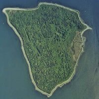 Aerial photo of Patience Island. (Source: NOAA)
 This 207-acre island lies to the west of northern Prudence Island. At their closest point, the two islands are only 900 feet apart. The island is dominated by tall shrubs interspersed with red cedar and black cherry. Common shrubs include bayberry, highbush blueberry, and shadbush. Much of the island is also covered by brier, Asiatic bittersweet and poison ivy. A deciduous forest is gradually replacing the shrub habitat in some parts of the island. The small salt marsh on the southeastern shore provides habitat for seablite, a plant species common in other areas of the country, but rare in Rhode Island. The upland area of Patience Island supports a variety of wildlife including white-tailed deer, red fox, and Eastern cottontail rabbits. Coastal areas are used extensively by migrant and wintering waterfowl species such as horned grebes, greater scaup, black ducks and scoters. Quahogs are abundant in the sandy sediment.
There is no ferry service available to this island. Visitors are welcome but you must provide your own transportation. Be aware that there is a high population of ticks, the trails may be overgrown, and camping is not permitted.
History of Patience Island
Historically, the Patience Island Farm covered an area of approximately 200 acres, nearly the entire island, and was a working farm as early as the mid-seventeenth century. The farm buildings were burned by the British during the Revolutionary War. After the war, the buildings were rebuilt and the farm remained in operation until the early twentieth century. During the 1960s, construction was undertaken to create a summer resort colony on the island. The colony was never completed, however the construction did considerable damage to the sites of the early farm buildings.
There is also another archaeological site, separate from the farm. This is the foundation of an oysterman's house along the northwest shore. The site probably dates back to the late eighteen century when the oysterbeds were leased in the upper bay. The small building was the home of a watchman for the oysterbeds located just off Patience Island. The foundation of the house remains in good condition with little apparent disturbance.
Biodiversity
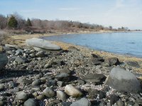 Northwestern coast of Patience Island, April 2004. (Source: NOAA)
 Flora: Upland vegetation includes dense concentrations of tall shrubs interspersed with red cedar as overstory. Dominant shrubs include bayberry, black cherry, highbush blueberry, shadbush, poison ivy and European bittersweet. Deciduous forest is gradually replacing the shrub habitat in some parts of the island.
Fauna: White-tailed deer inhabit the island, part of the shared population with Prudence Island. The upland areas, with their early successional vegetation, also support red fox, eastern cottontail rabbit and ring-necked pheasant. Core areas along the shore are used extensively as feeding areas by migrant and wintering waterfowl species. Common loons and horned grebes occur frequently, as do greater scaup, great cormorants, canvas-backed ducks, black duck and scoters. Quahogs are abundant in the sandy sediment.
Endangered Species: The salt marsh contains the seablite, a plant species common in other areas of the country, but rare in Rhode Island. There are only four other recorded sites for this species in the state. As a result, the plant is classified as "of special concern" by the Rhode island Natural Heritage Program.
Soil Types
The northeastern third of the island is overlaid with glacial outwash; most of the rest of the island is glacial till. The outwash soils are predominantly stratified sand and gravel, while the westerly side of the island with its till-derived soils is made up of silty, richer soils.
The silt loam (Newport series) soils on the western side of the island helped to support the farming efforts that were carried on at the site for more than 200 years.
The southern tip of the island is overlain with Popuonock loamy, fine sand, which is primarily wind-blown sand that was deposited after the glacier receded. These are dry soils that have a depth of up to four feet overlying the richer loam beneath.
Hope Island
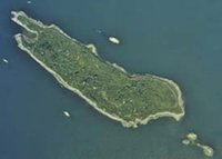 Aerial view of Hope Island. (Source: NOAA)
 This small, 91-acre island lies 1.5 miles west of southern Prudence Island and 3 miles south of Patience Island. The topography of Hope Island is very irregular, with numerous low hills, ledges, and rocky outcrops and the shoreline is generally steep and rocky. There is one, small freshwater wetland located in an isolated depression in the south central portion of the island. Much of the northern end of Hope Island is vegetated by grasses but many other areas have shrubs including bayberry, rose, and poison ivy. The central part of the island contains tall shrubs and trees such as red cedar, staghorn sumac, shadbush, and black willow. A single strand of black locust occupies a low hill on the northern part of the island. Hope is inhabited by the Eastern cottontail rabbit and serves as one of the most significant nesting areas on the East coast for wading birds. In addition to the egret and heron rookery, many black-backed and herring gulls nest on the rocks. During the winter, harbor seals occasionally use the exposed offshore rocks as haulout and resting sites. Soft-shelled clams, quahogs, American lobsters, striped bass, tautog, black-backed flounder, and sea trout are abundant in the waters around Hope Island. The present nesting colonial wading birds include great egrets, snowy egrets, and black-crowned night herons. Other nesting birds include double-crested cormorants, Canada geese, herring gulls and black backed gulls.
History of Hope Island
There is an 18th century farm site on the west side of Hope Island. To date, no archaeological work or documentary research has been carried out relating to this site. During World War II the island was used by the Navy as an ammunition storage site. There are still ammunition bunkers and concrete roads remaining from this period.
There is a 3/4-mile abandoned military road around the perimeter of the island but the island is closed during the nesting season of the colonial nesting birds.
Biodiversity
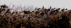 Double-crested cormants on Hope Island. (Source: NOAA)
 Flora: The vegetation is primarily early successional, resulting from the Department of Environmental Management's practice of periodically burning large areas of the island. Much of the northern end of Hope Island is predominantly vegetated by grasses.
Many other areas have low shrubs: bayberry, rose, blackberry and poison ivy. The central part of the island contains tall shrubs and sapling trees, including red cedar, staghorn sumac, shadbush, black cherry and black willow. A single strand of black locust occupies a low hill on the northern part of the island.
Fauna: The island is inhabited by the eastern cottontail rabbit and serves as one of the most significant nesting areas on the East Coast for wading birds. In addition to the egret and heron rookery, many black-backed and herring gulls nest on the rocks of Hope Island. During the winter, harbor seals occasionally use the exposed offshore rocks as haulout and resting sites. Soft-shelled clams, quahogs, American lobsters, striped bass, tautog, black-backed flounder and sea trout are abundant in the waters around Hope Island.
Present nesting colonial wading birds include great egrets, snowy egrets and black-crowned night herons. Other nesting birds include double-crested cromorants, Canada geese, herring gulls and black-backed gulls.
Geology
There are many outcrops of bedrock on the island. This bedrock is part of the Rhode Island Formation. It is Pennsylvanian-age slate, siltstone and conglomerate that has been highly metamorphosed.
The soils are extremely rocky, fine, sandy-loam derived from glacial till. This soil of the Canton and Charlton series is relatively thin in some areas and thick in other places over the bedrock. Two small freshwater wetlands have two small ponds that may be pocketed on bedrock or be underlain by tight soil material (hardpan).
Prudence Island
 Prudence Island map. (Source: NOAA)
 Prudence Island is located in the geographic center of Narragansett Bay. The island is approximately 7 miles long and 1 mile across at its widest point. The NBNERR Learning Center which contains educational exhibits, a public meeting area/library, and research labs for staff and visiting scientists, is located at the south end of this island. NBNERR manages approximately 60% of Prudence; the largest components are at the North and South ends.
The vegetation on Prudence Island reflects the extensive farming that took place in the area until the early 1900s. After the fields were abandoned, woody plants gradually replaced the herbaceous species. The uplands are now covered with a dense shrub growth of bayberry, blueberry, arrowwood, and shadbush interspersed with red cedar, red maple, black cherry, pitch pine and oak. Green briar and Asiatic bittersweet cover much of the island as well.
Prudence Island also supports one of, if not the most dense white-tailed deer herd in New England. Raccoons, squirrels, Eastern red fox, Eastern cottontail rabbits, mink, and white-footed mice are plentiful. The large salt marshes at the north end of Prudence are used as feeding areas by a number of large wading birds such as great and little blue herons, snowy and great egrets, black-crowned night herons, green-backed herons and glossy ibis. Between September and May, Prudence Island is also used as a haul-out site for harbor seals.
History of Prudence Island
Before colonial times, Prudence and the surrounding islands were under the control of the Narragansetts. They referred to Prudence as Chibchuwesa, “a place apart.” There is no archeological evidence of a long standing, permanent tribal community on Prudence, and it is believed that it was used on an occasional basis for specific purposes.
Roger Williams, founder of Rhode Island, acquired the islands from Narragansett Sachem Canonicus, but there is also a record of the Wampanoag Massasoit Ousa Mequin bestowing this same gift upon him. The Narragansetts have the stronger claim, however, with documentation in the form of a deed turning the islands over to Williams and Governor Winthrop of Massachusetts. Williams is credited with naming the islands Prudence, Patience and Hope after three virtues that everyone should possess.
Agriculture was the primary use for Prudence Island during the Colonial era, although it was abandoned for a time during the Revolutionary War. For the next century, the island remained sparsely populated, with fewer than two dozen families in residence.
 These U.S. Navy trucks were used for the movement of ammunitions from underground magazines to the ships in 1943. (Source: NOAA)
 Farms were also located on Patience and Hope Islands during that time. The Patience Island farm was burned during the Revolutionary War, but was rebuilt and operated until the early twentieth century. Little is known about the Hope Island farm.
By the late 1800s, Prudence began to attract summer residents, and cottages were built along its western shore. The community was known as Prudence Park. Transportation was provided by steamboat from Providence. Later, a ferry from Bristol was started by Halsey Chase, who owned a hotel on the island. The Prudence Island Navigation Company was chartered in 1921, bringing a new era of development on Prudence. Many cottages were built in several small communities along the eastern shore.
The U.S. military established a presence on Prudence with an army camp built during World War II. It provided a base for search lights and light artillery, and was abandoned in 1947. A Naval Magazine was constructed on Prudence Island in April of 1942. Hope Island was also used as a munitions dump at that time. The Navy kept possession of the base until 1972. The land was subsequently turned over to the State of Rhode Island , and was designated a National Estuarine Research Reserve in 1980.
Prudence Island has been sheltered from the impact of the large population densities normally associated with coastal New England, largely because it has always remained comparatively inaccessible and because commercial development has been actively discouraged by its residents. Approximately 150 people spend their winters on Prudence. The population swells to more than 10 times that number during the summer. Patience, Hope and Dyer Islands are uninhabited.
Prudence Island has benefited from active conservation measures. About 70% of its land area has been designated as an estuarine reserve or acquired by local conservation organizations. Patience, Hope, and Dyer Islands have been preserved in their entirety, ensuring that these unique and important resources will remain a haven for wild things for generations to come.
Biodiversity
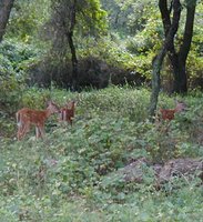 White-tailed deer triplets. Prudence is overpopulated with deer and as a result, there are significant ecological, herd health, and human health impacts. (Source: NOAA)
 Flora: The vegetation of the uplands reflects the extensive farming that took place in the area until the early 1900s. After the fields were abandoned, woody plants gradually replaced the herbaceous species. The uplands are now covered with dense shrub growth of arrowwood viburnum, bayberry, blueberry and shadbush, interspersed with red cedar, red maple, sapling oaks, pitch pine, black cherry, common greenbriar and blackberry. Deciduous forest, primarily mixed oak, is slowly replacing the shrubs in some areas.
The salt marsh plant community dominates the northwest shore. The predominant plant species in the salt marshes are saltmeadow grass (Spartina patens), cordgrass (Spartina alterniflora) and spike grass (Distichlis spicata). Other common salt marsh plants include black rush, saltwort, marsh lavender and marsh elder. Eelgrass (Zostera marinarus) is found between Patience and Prudence islands and along the east shore of South Prudence.
Fauna: The island supports the most dense white-tailed deer herd in New England. Raccoons, eastern red fox, eastern cottontail rabbits, mink and white-footed mice are plentiful at the north end of the island. A colony of least terns nests during the summer on Gull Point. The large salt marshes at North Prudence Island are used as feeding areas by a number of large wading birds—great blue herons, green-backed heron, little blue herons, great egret, snowy egret, black-crowned night heron and the glossy ibis. All of these species, except the great blue heron and green-backed heron, nest on Hope Island.
Fiddler crabs and green crabs are found in the Reserve's marsh areas, as well as common snail species, including salt marsh snails, mud snails and the common periwinkle. The most abundant fish in the salt marsh channels are mummichogs and silversides. During the winter, seals (mostly harbor seals) congregate on the rocks off the southeastern coast and off the northern tip of the island.
Endangered Species: Golden aster has been found growing on a sandy embankment overlooking the kettlehole pond. This is only the fifth recorded site for golden aster in Rhode Island and is the most prolific stand in the state. Golden aster is considered to be a Regionally Significant Species by the New England Botanical Club. It is designated Threatened by the Rode Island Natural Heritage Program.
The salt marsh at Coggelshall Cove may be a nesting site for the seaside sparrow, a species classified as "of special concern" by the Rhode Island Natural Heritage Program.
Geology
Approximately half of North Prudence is glacial till and the other half is glacial outwash. Near Pine Hill (the outwash area) is a kettle hole created during the glacial period. This depression interrupts groundwater, so the kettle hole has become a small pond. The glacial till near Potter Cove and in the vicinity of the old airstrip is classified as Newport silt loam. The silt in this rich soil retains moisture better than the sandy outwash soils that cover much of North Prudence. Several features exemplify the dynamic aspect of coastal geologic processes. A bay spit in front of Jenny Creek is moving into the salt marsh at a rate of about one meter per year. A recurved spit, Gull Point is continually growing and being reshaped by the northeast and northwest winds.
There are extensive salt marshes on the west side of the island. These marshes, like most salt marshes in the northeastern United States, are believed to have been formed in the past 3,000 to 4,000 years, a time when relative sea level has been slowly rising at approximately one mm per year. These marshes have been ditched since, probably during the 1930s in order to control mosquitoes. By 1938, almost 90 percent of the salt marshes from Maine to Virginia had been ditched in this way.
Central and South Prudence have fields and forested uplands. The soil is glacial fill overlying a shale bedrock.
Dyer Island
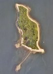 Aerial view of Dyer Island, 1996. (Source: NOAA)
 Dyer Island is a low-lying 28-acre island situated approximately halfway between Aquidneck Island and the south end of Prudence Island. Despite its small size, Dyer Island's ecological value is significant. It supports one of the last remaining salt marshes without mosquito ditches in Rhode Island and is a nesting area for coastal shorebirds including the locally rare American oystercatcher.
This uninhabited island also provides foraging habitat for a variety of shorebirds and was found to support 47 species of seaweed – a diversity second only to Rose Island in the bay. In September 2001, Dyer Island was acquired for preservation and incorporation into the Narragansett Bay National Estuarine Research Reserve using state and NOAA funds. It will be used in perpetuity for research, monitoring, education, and passive recreation.
Research
One of the primary functions of the NERRS is to protect relatively pristine [[habitat]s], representative of the biogeographic regions in which they are located, in order to provide platforms for conducting estuarine research and monitoring. This effort has come to fruition at the NBNERR where research and monitoring has been, and continues to be, conducted by scientists from a multitude of outside institutions and is now supplemented by an active internal NBNERR research and monitoring program.
NBNERR was established to provide an ideal place for conducting coastal and estuarine research, and it provides support in a variety of ways to do so. Until recently, NBNERR financial and logistical support has only been directed at efforts to conduct research within the 18-foot depth boundary of the reserve around the four islands. A new approach that focuses on all of Narragansett Bay and its watershed, adopted only in the last few years, should expand the amount of research conducted by and supported by NBNERR. It is hoped that the new approach will better incorporate the NBNERR into the local and regional scientific community and better promote quality research in Narragansett Bay and its watershed.
As with monitoring, research in the NBNERR is conducted by both visiting researchers and by the NBNERR staff, and it covers a wide variety of topics. Much of the work by visiting researchers has been funded and promoted by the NERR Graduate Research Fellow program and through the Cooperative Institute for Coastal and Estuarine Environmental Technology (CICEET). However, NBNERR has attracted other visiting researchers in addition to these programs. This includes researchers from Brown University, the University of Rhode Island, the U.S. Environmental Protection Agency, the Smithsonian, the Lloyd Center, Roger Williams University, the University of Houston, and Save the Bay among many others.
Partners and Supporters
Managed by the Rhode Island Department of Environmental Management, the reserve has strong partnerships with the Audubon Society of Rhode Island and the Prudence Conservancy. The Audubon Society offers educational programs for reserve visitors and maintains interpretive exhibits at the reserve's learning center. The Prudence Conservancy operates a citizen's volunteer water quality monitoring program for the reserve and provides stewardship, education and natural resource monitoring for the public.
Further Reading
| Disclaimer: This article is taken wholly from, or contains information that was originally published by, the National Oceanic and Atmospheric Administration. Topic editors and authors for the Encyclopedia of Earth may have edited its content or added new information. The use of information from the National Oceanic and Atmospheric Administration should not be construed as support for or endorsement by that organization for any new information added by EoE personnel, or for any editing of the original content. |