Murray River
The Murray River rises in the Australian Alps and its catchment comprises most of the land area of the provinces of Victoria and New South Wales as well as a portion of southern Queensland, Australia. The basin, often referred to as the Murray-Darling River system, is credited with a combined river length of 3701 kilometres, and is thus the longest river on the continent.
Elevated salinity and eutropication the Murray-Darling Basin are ongoing issues, arising from the Australian government's overzealous water infrastructure activities. According to the Australian government, 38 percent of the Murray-Darling was significantly impaired with regard to biota as of 2001. Species richness in the river basin is relatively high compared to other parts of Australia; moreover, the endemism in fish taxa, amphibians and reptiles is notably elevated.
Contents
Basin and course
The entire Murray-Darling Basin drains an area of over 1,000,000 square kilometres, or 14 percent of the entire continent. The Darling River is the chief tributary of the Murray, with the Balonne, Culgoa, Barwon, Warrego, and Paroo Rivers, draining the highest peaks of Australia, being the main tributaries to the Darling; the Culgoa and Barwon Rivers confluence to form the official beginning of the Darling. Another important headwaters segment is the Narran River, one of the two distributaries of the Balonne; the Narran River feeds the Narran Wetlands, a key set of ephemeral swamps for the sustenance of waterbirds.
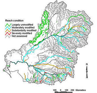 Murray-Darling Basin, southeast Australia. Source: Australian Government The Murray mainstem drains most of the land area of New South Wales and Victoria, and its health suffers from agricultural irrigation schemes and government over-regulation. Several times in recorded history the Murray has ceased flowing at certain points, with the high evaporation and percolation overwhelming the dry season flow rate.
In the lower reach prior to reaching the mouth, a major geologic event occurred around 25,000 years before present; at that time the Cadell Fault caused a sudden uplift which forced a bifrcation of the Murray. The northern channel, termed the Edwards River, carried most of that distributary flow. The southern distributary, known as the Goulburn River, flowed into a lake that originally lacked an outflow; however, the lake's natural perimeter dam failed and created the present southern channel known as the Narrows. The Edwards River and Narrows eventually rejoin prior to the Murray River mouth.
Upper reaches
Mammals found in both the upper and lower reaches of the Murray Basin include the Near Threatened Brush-tailed Rock Wallaby (Petrogale penicillata), which is near-endemic to the basin; and the Grey-headed Flying Fox (Pteropus poliocephalus), which is a southeast Australia endemic, but whose range has greatly retreated in the upper Murray Basin over the last century.
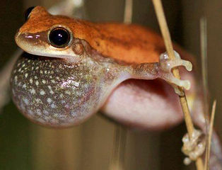 Red Treefrog. Source: Beth Mantle/EoL The Red Treefrog (Litoria rubella) and Peron's Treefrog (Litoria peronii) occur in both upper and lower basins of the Murray-Darling, with the Red Treefrog being widely distributed throughout Australia. The Victoria Ground Froglet (Geocrinia victoriana) is found in upper and lower Murray reaches, and is a near-endemic to the watershed. The Red Cryptic Treefrog (Litoria paraewingi) is a near endemic to the entire Murray Basin, and its range also extends into the Southeast Australian temperate forests and savanna.
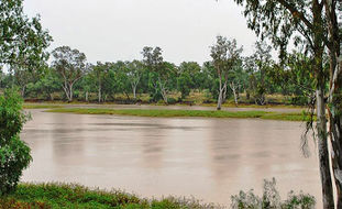 Balonne River, Darling tributary, near St.George, Queensland. cc-3.0 Other amphibians seen in the upper reach include the Broad-palmed Frog (Litoria latopalmata) and the Green-striped Burrowing Frog (Litoria alboguttata), the distribution of both anurans continues into much of the lower reach of the Murray Basin. The Endangered Southern Bellfrog (Litoria raniformis) is found in the upper and lower reaches of the basin; this anuran has suffered a severe decline in population and range since 1990, and presently is a near-endemic to the Murray Basin.
Two other amphibians that occur in both the upper and lower reach of the Murray-Darling Basin are: the Crucifix Toad (Notaden bennettii), which is actually a near-endemic of the basin; and Lesueur's Treefrog (Litoria lesueurii ), a southeast Australia endemic species.
Reptiles found in the upper basin include the Black Rock Skink (Egernia saxatilis), which taxon also occurs in parts of the lower Murray Basin. The Blotched Blue-tongued Lizard (Tiliqua nigrolutea) is also found in the upper basin as far as the slopes of the Blue Mountains, and its range also continues to the lower basin.
Lower reaches
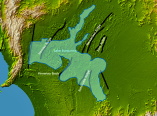 Reconstruction of Lake Burgunnia, ca one million years ago. Source: Graeme Bartlett Approximately 2,500,000 years before present, the Murray River became obstructed by an ancient uplift of over 250 metres high in the Grampian Mountains of Victoria. The ensuring effective natural dam created Lake Bungunnia, which water body covered over 40,000 square kilometres, and deposited a Blanchetown Clay layer. Eventually the water level of Lake Bungunnia fell, due to an ancient climate vicissitude of declining precipitation, with smaller saline lakes being formed, with accompanying dolomite deposition. By about 700,000 years before present, Lake Bungunnia no longer existed.Certain areas of small saline lakes are still extant at the present time.
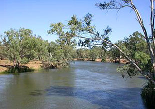 Murray River branch near Howlong. Source: Arria Belli The majority of the lower basin has been cleared for agriculture, chiefly to create pastureland and cereal cropland; however, this lower basin was originally vegetated with mallee woodlands, a multi-stemmed plant emanating from the large lignotubers of various Eucalyptus species forming the canopy. The understory was originally dense, consisting of large Xanthorrhoea tussocks and small-leaved sclerophyllous shrubs such as of the genera Acacia, Baeckea, Banksia, Grevillea, Hakea, Leptospermum, and Melaleuca. In more arid parts of the lower basin, the understory is sparse and of lower height, involving either salt-loving chenopod shrubs, such as Atriplex stipitata, Aboriginal Saltbush (A. vesicaria), Ruby Saltbush (Enchylaena tomentosa), or Triodia hummock grasses with scattered Zygophyllum shrubs.
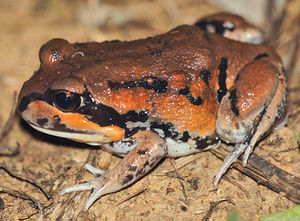 Giant Banjo Frog, New South Wales. Source: David Cook/INaturalist/EoL Mammals found in the lower reach include the Little Pied Bat (Chalinolobus picatus), whose range also includes some areas to the more arid west.
Amphibians found in the lower basin (in addition to those taxa specified above in the upper basin to also occur in the lower basin) include the Giant Banjo Frog (Limnodynastes interioris), which is endemic to the floodplains of the lower Murray Basin. The Eastern Banjo Frog (Limnodynastes dumerilii) is also found in the lower reach of the basin, and its range also extends westward into more arid regions of Australia. The Salmon-striped Frog (Limnodynastes salmini) and Long-thumbed Frog (Limnodynastes fletcheri) are found in the lower Murray Basin, and their ranges extend somewhat into the upper basin.
Spencer's Treefrog (Litoria spenceri) is a Critically Endangered anuran occurring in the Murray Basin, with a very limited area of distribution. The Wrinkled Toadlet (Uperoleia rugosa) is also found in the lower basin. The Painted Spadefoot Toad (Neobatrachus pictus), a limited range southeast Australian endemic whose distribution extends from the lower Murray Basin somewhat west into the more arid South Australia. Sloane's Froglet (Crinia sloanei) and Sudell's Frog (Neobatrachus sudelli) are also found in the lower Murray Basin. The Woodland Water-holding Frog (Litoria verrucosa) occurs in the lower basin and also somewhat to the west of the basin.
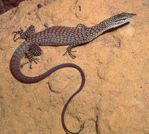 Arid Monitor, Murray-Darling Basin, Queensland. Source: Geordie Torr Reptiles found in the lower reaches of the basin include the Critically Endangered Eared Legless Lizard (Aprasia aurita), a Murray Basin endemic whose range is now thought to be restricted to the 60 square kilometre Wathe State Reserve. Another example reptile in the lower basin is the Arid Monitor (Varanus tristis). Another notable reptile found in the lower basin is the Central Bearded Dragon (Pagona vitticeps), whose range extends somewhat to the upper basin.
Bird species in the lower Murray Basin include the Endangered and limited range Black-eared Miner (Manorina flavigula melanotis) and the Endangered Mallee Emu-wren (Stipiturus mallee), which is near-endemic to the lower Murray Basin, and also occurs in the Mount Lofty woodlands not far from the Murray Mouth and slightly west into the Eyre and York mallee. The Vulnerable Mallee Fowl (Leipoa ocellata) is also found in the lower basin.
River mouth
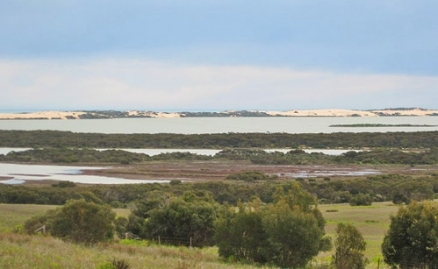
The mouth of the Murray River is near the eastern end of the Indian Ocean, not far from Kangaroo Island. Over time the actual river channel has shifted, flowing in differing locations among the coastal dunes. Presently the mouth is configured to discharge betwixt two distinct sand peninsula landforms. The elongated Younghusband Peninsula separates the Coorong lagoon system from the sea at the southeastern part of the mouth. Sir Richard Peninsula at the northwest separates the Goolwa (main) channel from the Indian Ocean. The Murray Mouth is separated from Lake Alexandrina by a set of low-lying islands. Hindmarsh Island is the largest such island, immediately in front of the mouth. Barrages join the islands, separating the seawater from the fresh water. The barrages are breached in periods of elevated river discharge.
Water quality
The Australian government's well-intentioned promise to produce a virtually unlimited supply of agricultural water to the Murray-Darling Basin has resulted in significant adverse impacts with regard to water pollution. (Bermingham. 2000) Excessive agricultural irrigation has produced an elevated water table, where plant roots tend to be exposed to the elevated salt mineral content. Furthermore, as Bermingham explains, the Australians attempted to follow a European model of irrigation in a basin with lower rainfall, and thus the concentrated runoff that contains phosphates and nitrates from cropland has led to widespread basin algae blooms.
Fish species
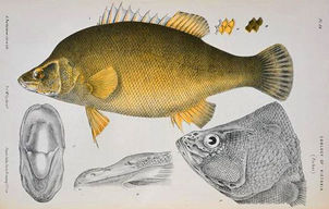 Golden Perch. Source: Arthur Bartholomew/EoL The rate of endemism of fish species in the Murray-Darling River system is exceptionally high. Endemic taxa include the two freshwater demersal 104 centimetre (cm) Endangered Trout Cod (Maccullochella macquariensis) and the 39 demersal Two-spined Blackfish (Gadopsis bispinosus). The 93 cm demersal Golden Perch (Macquaria ambigua) is another Murray-Darling endemic. The Spangled Perch (Leiopotherapon unicolor) is a hardy, high trophic level demersal fish that can achieve an adult length of about 38 cm; this omnivore is considered endemic to the Murray-Darling Basin.
Silver Perch (Bidyanus bidyanus) is a 49 cm benthopelagic fish endemic to the Murray-Darling Basin; this species is a potamodromous fish that prefers rapidly moving waters. The River Blackfish is a near-endemic benthopelagic 60 cm fish that is found on gravelly bottom substrates in the Murray-Darling Basin and also found in Tasmania. The Macquarie Perch (Macquaria australasica) is another benthopelagic near-endemic to the Murray-Darling Basin that also occurs in a few smaller southeast Australia coastal watershed; the Tasmanian Pygmy Perch (Nannoperca australis) is a small benthopelagic near-endemic to the Murray-Darling Basin.
The Murray Jollytail (Galaxias rostratus) is a 15 cm native benthopelagic fish species found in the Murray-Darling Basin.
Conservation
There are several protected areas within the Murray-Darling Basin. In the lower basin lie the Murray Sunset National Park and the Hattah-Kulkyne National Park, both of which are some of the last strongholds of the Mallee Emu-wren, the Mallee Fowl and the Black-eared Miner.
The 1346 square kilometre Little Desert National Park is an interesting site in Victoria near the South Australia border, where the only motorised access is via four wheel drive vehcicle. The Coorang National Park is a protected tidal wetland and Important Bird Area situated at the mouth of the Murray River; part of the Coorang is the Younghusband Peninsula, one of the most elongated peninsulas on Earth, at 110 kilometres in length and less than three kilometres wide.
References
- Australian Government National Water Commission. 2001. River condition in the Murray-Darling Basin 2001.
- Susan Bermingham. 2000. Changing Environments. Heinemann Publishers. 320 pages
- Ronald M. Berndt & Catherine H. Berndt. 1993. A World That Was: The Yaraldi of the Murray River and the Lakes, South Australia. Vancouver, Canada: UBC Press. ISBN 0-7748-0478-5.
- H.G. Cogger. 1992. Reptiles and amphibians of Australia, revised edition. Reed Books, Sydney, Australia. ISBN: 0801427398
- FishBase. 2011. Fish species in the Murray-Darling River system.
- Norman Mackay & David Eastburn (editors). 1990. The Murray. Canberra: Murray-Darling Basin Commission. ISBN1-875209-05-0.
- R. Thackway and I.D. Creswell. 1995. An Interim Biogeographic Regionalisation for Australia: A framework for establishing a national system of reserves, Version 4.0. Australian Nature Conservation Agency, Canberra, Australia.
- World Wildlife Fund. 2007. Murray-Darling woodlands.
