Mount Washington
| Topics: |
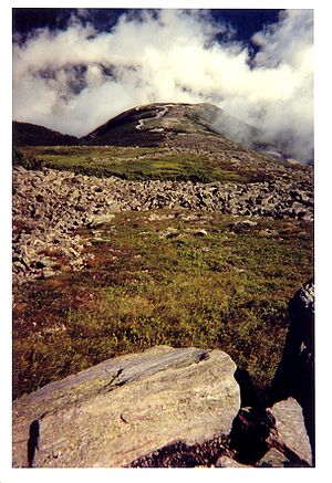 The summit of Mount Washington. (Source:[n])
 Mount Washington is the highest peak in the Northeastern United States and the only in the Northeast to exceed 6000 ft, reaching 6,288 ft (1,917 m). The mountain is located in the Presidential Range of the White Mountains, in Coos County, New Hampshire. It is famous for its dangerously erratic weather and holds the record for the strongest wind gust measured at the Earth's surface (231 mph). The Native American name for the mountain is Agiocochook, thought to mean "home of the Great Spirit."
Contents
Geographical features
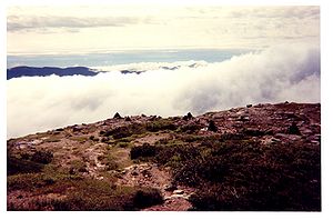 Clouds surround Mount Washington. (Source:[n])
 On the north side, Great Gulf — the mountain's largest glacial cirque — forms an amphitheater surrounded by the Northern Presidentials: Mounts Clay, Jefferson, Adams, and Madison. These connected peaks reach well into the treeless alpine zone. Massive Chandler Ridge extends northeast from the summit of Washington to form the amphitheater's southern wall.
East of the summit, a plateau known as the Alpine Gardens extends south from Chandler Ridge at about 5,200 ft elevation. It is notable for plant species either endemic to alpine meadows in the White Mountains or outliers of larger populations in arctic regions far to the north. Alpine Gardens drops off precipitously into two prominent glacial cirques. Craggy Huntington Ravine offers rock and ice climbing in an alpine setting. More rounded Tuckerman Ravine is sought after for spring skiing as late as June and in the summer as a scenic hiking route.
South of the summit lies a second and larger alpine plateau, Bigelow Lawn, at 5,000 ft to 5,500 ft elevation. Satellite summit Boott Spur and the Montalban Ridge including Mount Isolation and Mount Davis extend south from Bigelow Lawn, while the Southern Presidentials — Mounts Monroe, Franklin, Eisenhower, Pierce, Jackson, and Webster — extend southwest to Crawford Notch. Oakes Gulf separates the two high ridges.
Weather
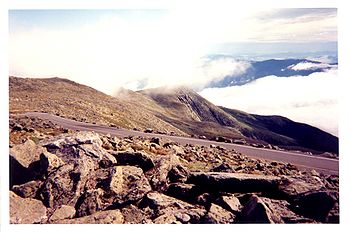 A section of the auto road to the summit. (Source:[n])
 Mount Washington has notoriously erratic and severe weather (extreme cold, precipitation and ice, strong winds, and low visibility). This is partly due to the convergence of three storm tracks, from the South Atlantic, Gulf region and Pacific Northwest. The steep slopes, plus the north/south orientation of the range, cause winds to accelerate as they move up the mountainsides. Low-pressure systems are more favorable to develop along the coastline in the winter months due to the relative temperature differences between the Northeast and the Atlantic Ocean. With these factors combined, winds exceeding hurricane force occur an average of 110 days per year. 134 hikers have died on the slopes of Mount Washington since 1849, with most due to the suprising speed with which the weather can change from pleasant to dangerous.
Mount Washington holds the world record for directly measured surface wind speed, at 231 mph, recorded on April 12, 1934. Phenomena measured via satellite or radar, such as tornadoes, hurricanes, and air currents in the upper atmosphere, are not directly measured at the Earth's surface and do not compete with this record.
The first regular meteorological observations on Mount Washington were conducted from 1870 to 1892 by the U.S. Signal Service, a precursor of the National Weather Service. The Mount Washington station was the first of its kind in the world, setting an example followed in many other countries. Mount Washington's official record low of ?50 °F was recorded on January 22, 1885. However, there is also hand-written evidence to suggest that an unofficial low of ?59 °F occurred on January 5, 1871.
On January 16, 2004, the summit weather observation registered a temperature of ?43.6 °F and sustained winds of 87.5 mph, resulting in a wind chill value of ?103 °F at the mountain. During a 71-hour stretch from January 13 to January 16, 2004, the wind chill on the summit never went above ?50 °F. Snowstorms at the summit are routine in every month of the year, with snowfall averaging 645 cm per year.
The primary summit building was designed to withstand 300 mph winds; other structures are literally chained to the mountain. In addition to a number of broadcast towers, the mountain is the site of the Mount Washington Observatory, a non-profit scientific observatory reporting the weather as well as other aspects of the subarctic climate of the mountain. The extreme environment at the top of Mount Washington makes using unmanned equipment problematic. The observatory also conducts research, primarily the testing of new weather measurement devices. The Sherman Adams summit building, which houses the Observatory, is closed to the public during the winter and hikers are not allowed inside the building except for emergencies and pre-arranged guided tours.
Mount Washington Observatory
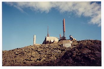 Part of Mount Washington Observatory. (Source: [n])
 The Mount Washington Observatory is a member-supported non-profit organization that has been recording weather and climate data at the summit of Moun Washington since 1932. The Mount Washington Observatory reoccupied the summit in 1932 through the enthusiasm of a group of individuals who recognized the value of a scientific facility at that demanding location. The Observatory's weather data have accumulated into a valuable climate record since. Temperature and humidity readings have been collected using a sling psychrometer, a simple device containing two mercury thermometers. Where most unstaffed weather stations have undergone technology upgrades, consistent use of the sling psychrometer has helped provide scientific precision to the Mount Washington climate record.
The Observatory makes prominent use of the slogan "Home of the World's Worst Weather", a claim that originated with a 1940 article by Charles Brooks (the man generally given the majority of credit for creating the Mount Washington Observatory), titled "The Worst Weather In the World" (even though the article concluded that Mt Washington most likely did not have the world's worst weather).
Research
Current sponsors of research at the Mount Washington Observatory include the National Oceanic and Atmospheric Administration, the National Aeronautics and Space Administration, the Appalachian Mountain Club, and the National Science Foundation. Current collaborators include the University of New Hampshire, the University of Virginia, and the AMC.
In the late 1990s the AIRMAP program established an air quality monitoring site on the summit. The primary mission of AIRMAP is to develop a detailed understanding of climate variability and the source of persistent air pollutants in New England. The goal is to identify the causes of climate variability, predict air quality changes as an addition to daily weather forecasts, and to demonstrate new forecasting technologies.
Observatory researchers, in collaboration with the Appalachian Mountain Club and the University of New Hampshire's Climate Change Research Center, are assessing climate and air pollutant trends and their influence on New England's high-elevation alpine ecosystems. Also supported by the National Oceanic and Atmospheric Administration’s Office of Oceanic and Atmospheric Research, this work builds on the Observatory's summit climate record and new observational systems, the AMC's long-term air quality and alpine ecosystem monitoring, and UNH's advanced pollutant measurement technologies.
Previous research includes:
Cosmo – A long-term neutron measurement project, under the tutelage of the late Dr. Jack Lockwood and Dr. Jim Ryan of UNH's Physics Department, Institute for the Study of Earth, Oceans, and Space. This was the longest running research project at the observatory, having run from 1955-2006.
Groundwinds – This wind measurement system measured winds from the ground up to 40,000 feet by using a laser beam and some very sophisticated optical techniques.
New England Air Quality Study (NEAQS) 2002 – The primary goal of the New England Air Quality Study is an improved understanding of the atmospheric processes that control the production and distribution of air pollutants in the New England region.
Polarstern Cruise – During the months of October and November 2003 the Observatory's former Chief Scientist Alex Pszenny and Staff Scientist Andy Wall participated in a research cruise aboard the German vessel Polarstern. Read the expedition with daily journal updates, photos from onboard, and information from the ship's meteorological service.
Snow Gauge Project – During the winter of 2000 two electronic devices that measure "liquid equivalent precipitation rate" were tested on the summit. The testing was one element of the FAA's Aviation Weather Research Program (AWRP); to increase the scientific understanding of atmospheric processes that cause the development of hazardous weather, which in turn, impacts aviation.
Sonic Anemometer – A new style of anemometer based on using sonics (sound waves) is being tested and evaluated on the summit for measuring wind speeds under adverse conditions.
Visibility Meter – An instrument on the summit currently being evaluated for ASOS (Auto Surface Obs System) that can determine visibility.
Mount Washington Icing Sensor Project (MWISP) – An April 1999 research project that evaluated remote sensing technologies for sensing icing conditions ahead of aircraft for avoidance and escape.
Conservation
The New Hampshire chapter of the Appalachian Mountain Club (AMC) claims 10,000 members and organizes trips, hikes, and volunteering in the White Mountains. They also have a Conservation Action Network (CAN) and a program called Mountain Watch. These groups keep record data regarding air quality, mountain plants, and mountain weather. An offshoot of Mountain Watch is the Adopt-a-Peak program volunteers agree to visit a peak or trail section periodically during the growing season. Volunteers can help keep track of plant flowering, fall foliage, and visibility conditions on the mountain they adopt. There is also an Alpine Stewardship Volunteer Program run by the AMC and the United States Forest Service. The Stewards educate hikers about Leave No Trace ethics (carry-in carry-out policies) and help campers stay safe in the mountains. More than 2,500 volunteers care for 1,500 miles of trails each year as part of the Trails Program. Volunteers install drainage, build bog bridges, and can also adopt a trail to maintain. The AMC also runs summer weeklong conservation programs for teens.
Recreation
The Mount Washington Road Race takes place each June on the auto road to the summit. Thousands of people have run the grueling 7.6 miles uphill from the base to the summit of the mountain since the race officially began in 1966. The first man to run up the auto road was a medical student named George Foster in 1904. The course record of 56:41.0 was set in 2004 by New Zealander Jonathan Wyatt.
The Mount Washington Auto Road Bicycle Hillclimb is another annual event that draws hundreds of participants. Bicyclists are not allowed on the auto road any other day of the year. All proceeds support the Tin Mountain Conservation Center in Albany, New Hampshire.
Note: This article was researched and written by a student at Boston University participating in the Encyclopedia of Earth's (EoE) Student Science Communication Project. The project encourages students in undergraduate and graduate programs to write about timely scientific issues under close faculty guidance. All articles have been reviewed by internal EoE editors, and by independent experts on each topic.
This article uses material from the Wikipedia article Mount Washington. The Author(s) and Topic Editor(s) associated with this article may have significantly modified the content derived from Wikipedia with original content or with content drawn from other sources. All content from Wikipedia has been reviewed and approved by those Author(s) and Topic Editor(s), and is subject to the same peer review process as other content in the EoE. The current version of the Wikipedia article may differ from the version that existed on the date of access. This article is licensed under the GNU Free Documentation License 1.2. See the EoE’s Policy on the Use of Content from Wikipedia for more information.