Mount Erebus
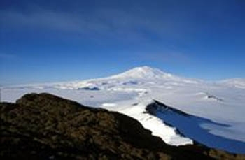
Mount Erebus, Ross Island, Antarctica. Source: Hannes Grobe
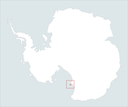 Location of Mount erebus, Ross Island, Antarctica.
 Mount Erebus is the southern-most active volcano on Earth. Part of the "Pacific Ring of Fire", Mount Erebus has a rather unusual long-lasting lava lake (250 meters wide) within its crater, 110 meters below the crater rim.
Standing 12447 feet (3794 meters) high, Erebus is located on Ross Island in Antarctica at 77 degrees 32'S; 167 degrees 10'E. The main Antarctic bases for the United States (McMurdo Station) and New Zealand(Scott Base) are approximately 22 miles south of the summit.
Mount Erebus is a Stratovolcano; that is, composed of alternating layers of lava and ash created by repeated eruptions. Erebus is characterized by “Strombolian”; activity; frequent and short-lived explosive outbursts, which eject relatively viscous lava a short distance (tens to hundreds of meters) into the air.
Human History
Mount Erebus was discovered on January 28, 1841, by a British expedition under the command of James Clark Ross who named it after one of the two ships of his expedition. (Erebus was a primordial Greek god.) The discovery was described by Ross’s surgeon McCormick:
We were startled by the most unexpected discovery in this vast region of glaciation, of a stupendous volcanic mountain in a high state of activity. At 10 A.M. upon going on deck, my attention was arrested by what appeared at the moment to be a fine snow drift, driving from the summit of a lofty crater-shaped peak, rising from the center of an island (apparently on the starboard bow). As we made a nearer approach, however, this apparent snow drift resolved itself into a dense column of black smoke, intermingled with flashes of red flame emerging from a magnificent volcanic vent, so near the South Pole, and in the very center of a mighty mountain range encased in eternal ice and snow.
The Discovery Expedition (1901-4) led by Robert Falcon Scott established its base at Hut Point 22 miles (35 kilometers) south of Mount Erebus (close to the present day site of McMurdo Station)and explored the approaches to the mountain but made not attempt to ascend it.
TheNimrod Expedition (1907-9) led by Earnest Shackleton established its base at Cape Royds, west of Mount Erebus.On March 10, 1908, five members of a six man party from the expedition (Jameson Adams, Edgeworth David, Alistair Mackay, Eric Marshall and Douglas Mawson reached the summit of Mount Erebus.
In 1956, the United States established a permanent research base, McMurdo Station, at Hut Point and a year laterNew Zealand opened its own research base, Scott Station, a mile away at Pram Point.Both bases were established for the International Geophysical Year and have supported continuous research on Mount Erebus. The New Mexico Institute of Mining and Technologyoperates theMount Erebus Volcano Observatory on the slopes of the volcano.
On November 28, 1979 Air New Zealand Flight 901 crashed into Mount Erebus, killing all 257 people aboard.
Volcanic History
Mount Erebus is thought to be about 1.3 million years old and to have evolved in the following manner:
| From ~1.3 million - 700,000 years ago, a broad low dome was formed followed by a phase where a steeper central cone built up. | 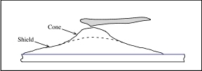 Image:ErebusEvolution1.jpg Image:ErebusEvolution1.jpg
|
| From ~700,000 - 350,000 years ago, the top of the cone was eroded or subsided to create Fang Ridge escarpment | 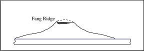 Image:ErebusEvolution2.jpg Image:ErebusEvolution2.jpg
|
| From ~350,000 -250,000 years ago, flows from the side opposite Fang Ridge expanded Erebus in that direction and built a new cone offset from the location of the first | 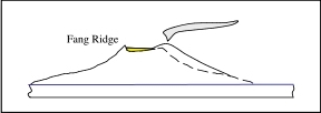 Image:ErebusEvolution3.jpg Image:ErebusEvolution3.jpg
|
| From ~250,000 - 90,000 years ago, continued eruption created the bulk of the current mount | 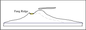 Image:ErebusEvolution4.jpg Image:ErebusEvolution4.jpg
|
| From ~90,000 - 70,000 years ago, the second cone subsided to produce the current caldera | 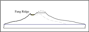 Image:ErebusEvolution5.jpg Image:ErebusEvolution5.jpg
|
| Over the past 70,000 years Erubus has continued to expand with the formation of a the current summit | 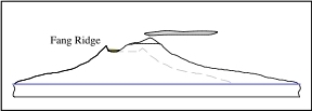 Image:ErebusEvolution6.jpg Image:ErebusEvolution6.jpg
|
Source: The Mount Erebus Volcano Observatory
See Also
Further Reading
- USGS Geographic Names Information System
- How Volcanos Work, Victor Camp, San Diego State University
- A Voyage of Discovery and Research in the Southern and Antarctic Regions,: During the years, 1839-43, James Clark Ross
- The Seventh Continent: A History Of The Discovery And Explorations Of Antarctica, Helen S. Wright, Kessinger Publishing, 2007
- The Mount Erebus Volcano Observatory accessed December 4, 2008.