Federated States of Micronesia
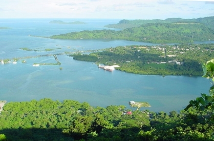
Kolonia Town, Pohnpei Island. Source: Wikimedia Commons
Countries and Regions of the World Collection  The Federated States of Micronesia is an island group in the North Pacific Ocean, about three-quarters of the way from Hawaii to Indonesia. It includes four major island groups totaling 607 islands and about 106,000 people extending 1,800 miles across the archipelago of the Caroline Islands east of the Philippines. Approximately 100 islands are inhabited. The four states are the island groups of Pohnpei (Ponape), Chuuk (Truk) , and Yap, and the island of Kosrae (Kosaie). The federal capital is Palikir, on Pohnpei.

The Chuuk islands are a classic example of an "almost-atoll". The huge, almost circular barrier reef has 69 islets, and is more than 60 km across at the widest point. The reef surrounds a central lagoon, which contains a mini-archipelago of 10 principal and many smaller volcanic islands. The largest island, Tol, reaches 443 meters (m) in elevation.
Pohnpei, 650 km to the east of Chuuk, is an extinct volcano, composed of weathered basalt. Geologically younger than Chuuk, it stands 734 m above sea level. The center of the island is a tableland with 11 separate peaks.
Kosrae has a maximum elevation of 629 m. The island is deeply dissected, and has several steep high peaks.
The Yap Islands group is located about 450 kilometers (km) northeast of Palau, near 10° N latitude and 140° E longitude. Yap Proper, also called "Wa’ab," consists of four islands separated by narrow channels. Three of the islands—Yap, Gagil-Tomil, and Maap—are connected by roads. The fourth, Rumung, is accessible only by boat. Yap has a gentle topography, rising to a maximum elevation of about 175 meters (m) on Mt. Matade. Geologically, the islands are composed of two distinct sequences: ancient weathered volcanic rock and weathered metamorphic schists. The islands are surrounded by a broad fringing barrier reef.

In 1979 the Federated States of Micronesia, a UN Trust Territory under US administration, adopted a constitution.
In 1986 independence was attained under a Compact of Free Association with the US, which was amended and renewed in 2004.
Present concerns include large-scale unemployment, overfishing, and overdependence on US aid.
Environmental concerns include: overfishing, climate change, and pollution.
The islands of the Federated States of Micronesia, together with the isalnds of Palau farthur west are referred to as the Caroline Islands.
The islands of the Federated States of Micronesia are also part of a larger cultural region called Micronesia which also includes, Palau, the Marianna Islands, the Marshall Islands, and Kiribati. Separate but related regions to Micronesia are Polynisia and Melanesia.
Contents
Geography
Location: Oceania, island group in the North Pacific Ocean, about three-quarters of the way from Hawaii to Indonesia
Geographic Coordinates: 6 55 N, 158 15 E
Area: 702 sq km Note; This includes Pohnpei (Ponape), Chuuk (Truk) Islands, Yap Islands, and Kosrae (Kosaie).
Coastline: 6,112 km
Maritime Claims:
Natural Hazards: typhoons (June to December)
Terrain: islands vary geologically from high mountainous islands to low, coral atolls. There are volcanic outcroppings on Pohnpei, Kosrae, and Chuuk. The highest point is Dolohmwar (Totolom) (791 m).
Climate: tropical; heavy year-round rainfall, especially in the eastern islands; located on southern edge of the typhoon belt with occasionally severe damage.
Ecology and Biodiversity
Ecologically, the most of the islands of the Federated States of Micronesia are within the Carolines tropical moist forests ecoregion. This ecoregion includes the outer islands of Yap State, known as the Remetau Group, and the States of Chuuk, Pohnpei, and Kosrae.
Located in the humid equatorial region on the southern edge of the typhoon belt, the islands at the eastern end of the Caroline chain are wet year-round, with precipitation becoming more seasonal toward the west. Rainfall in Pohnpei averages more than 4,500 mm annually, while parts of Kosrae, 550 km to the southeast, receive more than 6,400 mm per year.
Mature vegetation on the high volcanic islands is dominated by broadleaf evergreens. These high islands were probably almost completely forested at one time, with a few patches of savanna. Human activities have increased the extent of the savannas to cover large areas, especially in the western Carolines. Most of the lowland vegetation has been modified from its original forest state.
Pohnpei, at 335 km2, is the second largest island in the Carolines. It is also the highest and one of the wettest. The vegetation is less degraded than that of the other high islands to the west, and well-developed mangrove forests and freshwater swamp forests still exist in coastal areas. Some primary montane rain and cloud forest can be found on the slopes of the peaks in the center of the island. This upland forest can be divided into two major associations, with a Maesa carolinensis association at the lower altitudes (450 to 680 m), and a Cyathea ponapeana/Pandanus patina association on the upper slopes.
Around 300 meters (m) above sea level, the montane forest changes to a dwarf cloud forest, lushly covered with mosses and hepatics (members of the buttercup family). There are many epiphytes, including Elaphoglossum carolinense, Mecodium polyanthos, Lindsaea rigida, and Peperomia kusaiensis. This forest has not been thoroughly studied, but canopy trees include Cyathea ponapeana, Elaeocarpus carolinensis, and Astronidium kusaianum. Polyscias subcapitata and Eugenia stelechanthoides dominate the lower canopy, and the undergrowth includes ferns such as Marattia fraxinea and Pteris spinescens.
The atolls in the eastern Carolines are very flat, rising no more than a few meters above sea level. For atolls, they have an uncharacteristically diverse flora, probably because of the heavy rainfall. However, none of the known native species are particularly distinctive botanically. Vegetation on the atolls consists primarily of pan-tropical lowland strand species.
Pohnpei and Kosrae have the only remaining patches of montane cloud forest in Micronesia. These forests are also unusual because they are among the lower elevation cloud forests in the world, starting bit higher than 450 meters (m). Endemism is high, in part because the islands are relatively close to the floristically rich regions of Southeast Asia and in part because of their isolation and great age.
Semi-natural montane forest in Chuuk still occurs in small patches on the steeper slopes and on the summit of Uinipot Peak on Tol. The interior highlands of Kosrae and Pohnpei still support montane and cloud forests. Pohnpei has protected all of its mangrove forests and 51 km2 of its interior forests as a watershed reserve.
The Yap tropical dry forests ecoregion consists of the main Yap Islands in addition to the nearby atolls of Ulithi, Ngulu, Fais, and Faraulep. Much of Yap is currently open savanna resulting from high pre-contact human densities. The remaining tropical dry forest is largely secondary and contains a mixture of native and cultivated species. The islands support several endemic species of plants and birds, some of which are threatened by human activities and introduced species, the most notorious being the brown tree snake Boiga irregularis, which is responsible for many extinctions on Guam.
See also: Biological diversity in Polynesia-Micronesia
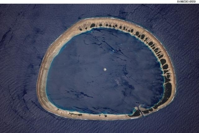
Classically shaped Nukuoro Atoll is one of 607 islands that make up the Federated States of Micronesia. About 900 people live on the atoll whose lagoon is 6 km (3.5 mi) in diameter. Vegetation patches are located on the northeast and east portions of the atoll that face the dominant Easterly winds. Swells driven by these winds can be seen approaching from the east-southeast (right) and wrapping around the atoll to produce an interference pattern on the downwind side. Water in the lagoon is calm in comparison. A coral head appears dead center of the photo. Image courtesy of NASA.
People and Society
Population: 106,487 (July 2012 est.)
The indigenous population consists of various ethno-linguistic groups. English has become the common language. The birth rate remains high at more than 3%, but the population of the four states remains almost constant due to emigration.
Ethnic Groups: Chuukese 48.8%, Pohnpeian 24.2%, Kosraean 6.2%, Yapese 5.2%, Yap outer islands 4.5%, Asian 1.8%, Polynesian 1.5%, other 6.4%, unknown 1.4% (2000 census)
Age Structure:
0-14 years: 33.6% (male 18,223/female 17,639)
15-64 years: 63.4% (male 33,566/female 34,215)
65 years and over: 3% (male 1,375/female 1,818) (2011 est.)
Population Growth Rate: -0.343% (2012 est.)
Birthrate: 21.85 births/1,000 population (2012 est.)
Death Rate: 4.31 deaths/1,000 population (July 2012 est.)
Net Migration Rate: -20.97 migrant(s)/1,000 population (2012 est.)
Life Expectancy at Birth: 71.8 years
male: 69.84 years
female: 73.85 years (2012 est.)
Total Fertility Rate: 2.68 children born/woman (2012 est.)
Languages: English (official and common language), Chuukese, Kosrean, Pohnpeian, Yapese, Ulithian, Woleaian, Nukuoro, Kapingamarangi
Literacy (age 15 and over can read and write): 89% (1980 est.)
Urbanization: 23% of total population (2010) growing at an annual rate of change of 1.3% (2010-15 est.)
Access to Improved Drinking Water Sources: 92% of population (2000)
Access to Improved sanitation Facilities: 26% of population (2000)
History
Ancestors of the Micronesians settled the Caroline Islands over 4,000 years ago. A decentralized chieftain-based system eventually evolved into a more centralized economic and religious empire based principally in Yap and Pohnpei. European explorers--first the Portuguese in search of the Spice Islands and then the Spanish--reached the Carolines in the 16th century, with the Spanish establishing sovereignty. The current FSM passed to German control in 1899, and then through the Treaty of Versailles to the Japanese in 1919. Following World War II, these islands became part of the United Nations Trust Territory of the Pacific Islands, administered by the United States.
On May 10, 1979, four of the Trust Territory districts ratified a new constitution to become the Federated States of Micronesia. The neighboring trust districts of Palau, the Marshall Islands, and the Northern Mariana Islands chose not to participate. The FSM signed a Compact of Free Association with the United States in 1986. An Amended Compact entered into force in June 2004.
The Government of the Federated States of Micronesia conducts its own foreign relations. Since independence, the FSM has established diplomatic relations with a number of nations, including most of its Pacific neighbors, Japan, Australia, and the People's Republic of China. Regional cooperation through various multilateral organizations is a key element of its foreign policy. The FSM became a member of the United Nations in 1991.
The Governments of the FSM and the United States maintain deep ties and a cooperative relationship. Reflecting a strong legacy of Trusteeship cooperation, over 25 U.S. federal agencies maintain programs in the FSM. Under the Compact, the United States has full authority and responsibility for the defense and security of the FSM. This security relationship can be changed or terminated by mutual agreement. Also under the Compact, Micronesians can live, work, and study in the United States without a visa. Micronesians volunteer to serve in the U.S. Armed Forces at approximately double the per capita rate as Americans; they are also eligible for admission to U.S. Service Academies. Americans can live and work freely in the FSM without the need for a visa.
The United States will provide about $100 million annually in assistance to the FSM until 2023. A Joint Economic Management Committee (JEMCO), consisting of representatives of both nations, is responsible for ensuring that assistance funds are spent effectively, with the aim of fostering good governance and economic self-reliance. The basic relationship of free association continues indefinitely.
The United States is the FSM's largest trade partner.
Government
Government Type: constitutional government in free association with the US; the Compact of Free Association entered into force on 3 November 1986 and the Amended Compact entered into force in May 2004
The FSM is governed under a 1979 constitution, which guarantees fundamental human rights and establishes a separation of governmental powers. The unicameral Congress has 14 members elected by popular vote. Ten senators represent single-member districts based on population and serve 2-year terms. Four senators at large--one from each state--are elected to serve 4-year terms. The President and Vice President are elected by Congress from among the 4 at large senators. Once elected, the President and Vice President serve for 4 years. Their congressional seats are then filled by special elections. An appointed cabinet supports the President and Vice President. There are no formal political parties.
The FSM is a confederation with a weak central government. Each of the FSM's four states has its own constitution and its own elected legislature and governor. The state governments maintain considerable power, particularly regarding the implementation of budgetary policies.
Capital: Palikir - 7,000 (2009)
Administrative divisions: 4 states; Chuuk (Truk), Kosrae (Kosaie), Pohnpei (Ponape), Yap
Independence Date: 3 November 1986 (from the US-administered UN trusteeship)
Legal System: accepts compulsory International Court of Justice (ICJ) jurisdiction; and accepts International criminal court (ICCt) jurisdiction. The FSM's highest court is the Supreme Court, which is divided into trial and appellate divisions. The President appoints judges with the advice and consent of the Congress.
International Environmental Agreements
The Federated States of Micronesia is party to international agreements on: Biodiversity, Climate Change, Climate Change-Kyoto Protocol, Desertification, Hazardous Wastes, Law of the Sea, and Ozone Layer Protection.
Resources
The islands have few mineral deposits worth exploiting, except for high-grade phosphate.
Natural Resources: timber, marine products, deep-seabed minerals, phosphate
Land Use:
Economy
Under the terms of the Compact of Free Association, the United States provided the FSM with about $2 billion in grants and services between 1986 and 2001. The Compact's financial terms were renegotiated for the 20-year period 2004 through 2023, with the aim of encouraging sustainable development. The United States will provide almost $100 million in direct assistance every year until 2023, which includes the systematic reallocation of a portion of the direct aid to a jointly managed Trust Fund. Additional federal grants and services to the FSM are estimated to be as much as another $100 million annually. Assistance under the Amended Compact is distributed by grants in response to a transparent FSM budget process, focusing on the following six sectors: education, health, infrastructure, public sector capacity building, private sector development, and the environment. The U.S. Department of the Interior is responsible for monitoring and implementing the Amended Compact.
The FSM government sector plays a central role in the economy as recipient and domestic administrator of Compact funds. The national and state-level governments employ over half of the country's workers. Government services and public enterprises account for 38% of GDP. Real wages nationwide have been flat and the number of jobs in the economy has generally been in decline since 1995. However, data does show an increase from 15,485 jobs in 2009 to 16,179 in 2010. Private sector jobs pay about half as much as public sector jobs.
The fishing industry is very important. Foreign commercial fishing fleets pay $15 million to $20 million annually for the right to operate in FSM territorial waters. These licensing fees accounted for 26% of the national government revenues in 2010. Exports of fish accounted for nearly 64% of export revenues in 2010.
Visitor attractions include scuba diving, surfing, World War II battle sites, eco-tourism, and the ancient ruined city of Nan Madol on Pohnpei. The islands have more than 24,000 tourists and visitors each year. The potential for a tourist industry exists, but the remote location, a lack of adequate facilities, and limited air connections hinder development, as well as a severely restrictive foreign investment climate. The Asian Development Bank (ADB) has identified tourism as one of FSM's highest potential growth industries.
Agriculture is mainly subsistence farming. The principal crops are breadfruit, coconuts, bananas, betel nuts, cassava, taro, and kava. Betel nut is becoming an increasingly important export with a yearly value estimated at $2 million to $4 million.
The large inflow of official assistance to the FSM allows it to run a substantial trade deficit--imports outstrip exports by a five-to-one ratio--and to have a much lighter tax burden than other states in the region (12% of GDP in FSM compared to 18%-25% elsewhere). In 2004, the FSM Government and Congress started steps toward establishing a nationwide tax system to improve collections and more fairly distribute the tax burden with assistance from the ADB, the Pacific Finance Technical Assistance Center (PFTAC), and the Australian Government, but the tax system remains unchanged. In 2011 and 2012 the FSM Congress approved the first and second of five laws required to implement the new system, but as of early 2012 only two of the four states had passed the necessary legislation, making the future of the reforms unclear.
Under the original terms of the Compact of Free Association, the US provided $1.3 billion in grant aid during the period 1986-2001; the level of aid has been subsequently reduced. The Amended Compact of Free Association with the US guarantees the Federated States of Micronesia (FSM) millions of dollars in annual aid through 2023, and establishes a Trust Fund into which the US and the FSM make annual contributions in order to provide annual payouts to the FSM in perpetuity after 2023.
The country's medium-term economic outlook appears fragile due not only to the reduction in US assistance but also to the current slow growth of the private sector.
GDP: (Purchasing Power Parity): $238.1 million (2008 est.)
GDP: (Official Exchange Rate): $238.1 million (2008)
GDP- per capita (PPP): $2,200 (2008 est.)
GDP- composition by sector:
agriculture: 28.9%
industry: 15.2%
services: 55.9% (2004 est.)
Agricultural products: black pepper, tropical fruits and vegetables, coconuts, bananas, cassava (tapioca), sakau (kava), Kosraen citrus, betel nuts, sweet potatoes; pigs, chickens; fish
Industries: tourism, construction; fish processing, specialized aquaculture; craft items (from shell, wood, and pearls)
Currency: US dollar