Kiribati
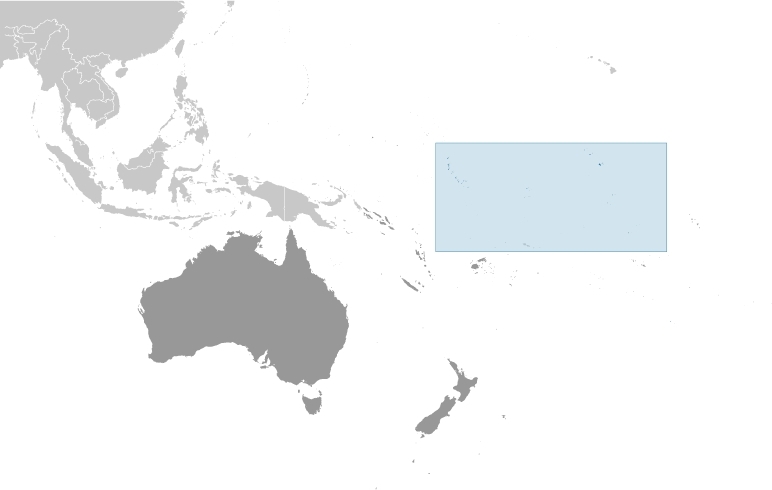
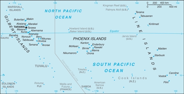
Countries and Regions of the World Collection  Kiribati (pronounced "keer-ah-bhass") consists of 32 low-lying atolls and one raised island scattered over an expanse of the Pacific Ocean equivalent in size to the continental United States. The islands straddle the Equator, as well as the International Date Line, and lie roughly halfway between Hawaii and Australia.. The three main groupings are the Gilbert Islands, Phoenix Islands, and Line Islands. In 1995 Kiribati unilaterally moved its date line to include its easternmost islands, putting the country in the same date and time zone. Kiribati is a group of 33 coral atolls with 102,000 people.
Kiribati includes Kiritimati (Christmas Island), the largest coral atoll in the world, and Banaba (Ocean Island), one of the three great phosphate islands in the Pacific. Except on Banaba, very little land is more than three meters above sea level.
The Gilbert Islands became a British protectorate in 1892 and a colony in 1915.
They were captured by the Japanese in the Pacific War in 1941. The islands of Makin and Tarawa were the sites of major US amphibious victories over entrenched Japanese garrisons in 1943.
The Gilbert Islands were granted self-rule by the UK in 1971 and complete independence in 1979 under the new name of Kiribati.
The US relinquished all claims to the sparsely inhabited Phoenix and Line Island groups in a 1979 treaty of friendship with Kiribati.
21 of the 33 islands are inhabited
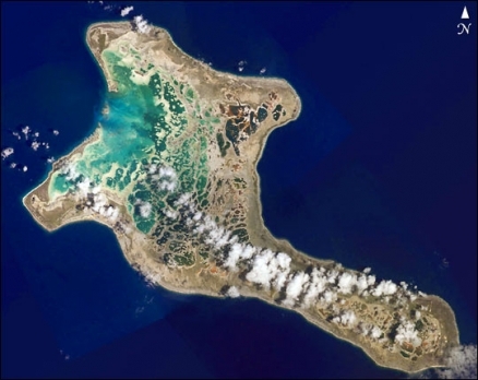
The largest atoll in Kiribati is Kiritimati Island (formerly Christmas Island). One of the Line islands, Kiritimati Island is the largest atoll in the Pacific Ocean. The atoll covers 606 sq km (234 sq mi), of which 243 sq km (94 sq mi) are land. The island was discovered by Captain James Cook in 1777. The majority of the island's inhabitants work on coconut plantations and in copra production. The island's major airbase is on the northeast side of the island. Nuclear tests were conducted on Kiritimati Island by the British in 1957 and 1958 and by the United States in 1962.
Banaba (Ocean Island) in Kiribati is one of the three great phosphate rock islands in the Pacific Ocean - the others are Makatea in French Polynesia, and Nauru.
Kiribati is the only country in the world to fall into all four hemispheres (northern, southern, eastern, and western)
President Anote Tong won re-election by a comfortable margin in January 2012 and has enjoyed a comfortable majority in Parliament. The biggest political issues of the day are climate change and employment opportunities for a crowded and growing population. Major environmental issues include: heavy pollution in lagoon of south Tarawa atoll due to heavy migration mixed with traditional practices such as lagoon latrines and open-pit dumping. Also ground water is at risk.
Contents
Geography
Location: Oceania,
Geographic Coordinates: 1 25 N, 173 00 E
Area: 811 sq km
Coastline: 1,143 km
Maritime Claims:
territorial sea: 12 nm
exclusive economic zone: 200 nm
Natural Hazards:
- typhoons can occur any time, but usually November to March;
- occasional tornadoes; and,
- the low level of some of the islands make them sensitive to changes in sea level
Terrain: mostly low-lying coral atolls surrounded by extensive reefs. The highest point is an unnamed elevation on Banaba (81 m).
Climate: tropical; marine, hot and humid, moderated by trade winds
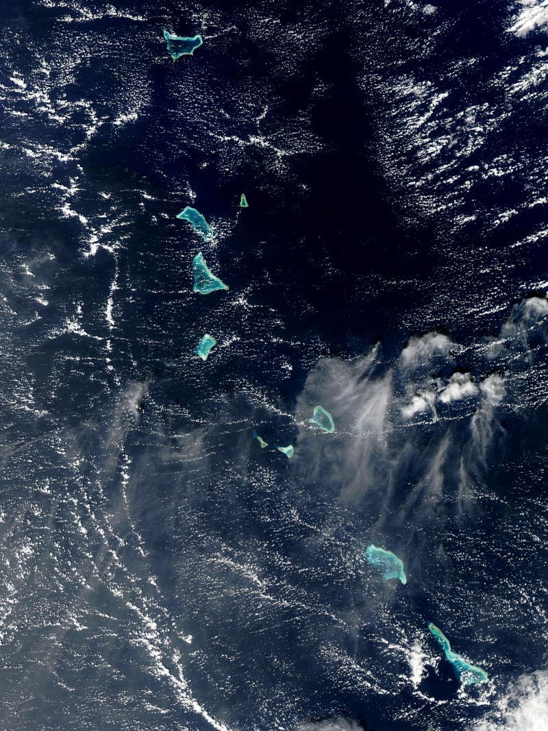
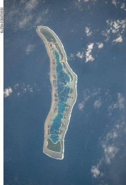
The Gilbert Islands of Kiribati. Source: NASA
Ecology and Biodiversity
The Eastern Micronesia tropical moist forests ecoregion includes the Gilbert Islands.
The Western Polynesian tropical moist forests ecoregion includes the Phoenix Islands which have been declared wildlife sanctuaries protected under Kiribati law, but are not patrolled.
The Central Polynesian tropical moist forests ecoregion includes the Line Islands
People and Society
The original inhabitants of Kiribati are Gilbertese, a Micronesian people. Approximately 90% of the population of Kiribati lives on the atolls of the Gilbert Islands. Although the Line Islands are about 2,000 miles east of the Gilbert Islands, most inhabitants of the Line Islands are also Gilbertese. Owing to severe overcrowding in the capital on South Tarawa, in the 1990s a program of directed migration moved nearly 5,000 inhabitants to outlying atolls, mainly in the Line Islands. The Phoenix Islands have never had any significant permanent population. A British effort to settle Gilbertese there in the 1930s lasted until the 1960s when it was determined the inhabitants could not be self-sustaining.
Population: 101,998 (July 2012 est.)
Ethnic Groups: Micronesian 98.8%, other 1.2% (2000 census)
Age Structure:
0-14 years: 33.9% (male 17,385/female 16,750)
15-64 years: 62.4% (male 30,598/female 32,259)
65 years and over: 3.7% (male 1,461/female 2,290) (2011 est.)
Population Growth Rate: 1.228% (2012 est.)
Birthrate: 22.45 births/1,000 population (2012 est.)
Death Rate: 7.31 deaths/1,000 population (July 2012 est.)
Net Migration Rate: -2.85 migrant(s)/1,000 population (2012 est.)
Life Expectancy at Birth: 64.76 years
male: 62.37 years
female: 67.26 years (2012 est.)
Total Fertility Rate: 2.71 children born/woman (2012 est.)
Languages: I-Kiribati, English (official)
Literacy (age 15 and over can read and write):
Urbanization: 44% of total population (2010) growing at an annual rate of change of 1.9% (2010-15 est.)
History
The I-Kiribati people settled what would become known as the Gilbert Islands between 1000 and 1300 AD. Subsequent invasions by Fijians and Tongans introduced Melanesian and Polynesian elements to the Micronesian culture, but extensive intermarriage has produced a population reasonably homogeneous in appearance and traditions.
European contact began in the 16th century. Whalers, slave traders, and merchant vessels arrived in great numbers in the 1800s, fomenting local tribal conflicts and introducing often-fatal European diseases. In an effort to restore a measure of order, the Gilbert and Ellice Islands (the Ellice Islands are now the independent country of Tuvalu) consented to becoming British protectorates in 1892. Banaba (Ocean Island) was annexed in 1900 after the discovery of phosphate-rich guano deposits, and the entire group was made a British colony in 1916. The Line and Phoenix Islands were incorporated piecemeal over the next 20 years.
Japan seized some of the islands during World War II. In November 1943, U.S. forces assaulted heavily fortified Japanese positions on Tarawa Atoll in the Gilberts, resulting in some of the bloodiest fighting of the Pacific campaign. The battle was a turning point for the war in the Central Pacific.
Britain began expanding self-government in the islands during the 1960s. In 1975 the Ellice Islands separated from the colony and in 1978 declared their independence. The Gilberts obtained internal self-government in 1977, and became an independent nation on July 12, 1979, under the name of Kiribati.
Post-independence politics were initially dominated by Ieremia Tabai, Kiribati's first President, who served from 1979 to 1991, stepping down due to Kiribati's three-term limit for presidents. The tenure of Teburoro Tito, Kiribati's second-longest serving President, was from 1994 to 2003. His third term lasted only a matter of months before he lost a no confidence motion in Parliament. (See the next section for an explanation of Kiribati's unique presidential system.) In July 2003, Anote Tong defeated his elder brother, Harry Tong, who was backed by former President Tito and his allies. Tong was re-elected for a second term as president in October 2007, and most recently defeated candidates Tetaua Taitai and Rimeta Beniamina to win a third term as president in January 2012.
Government
The constitution promulgated at independence establishes Kiribati as a sovereign democratic republic and guarantees the fundamental rights of its citizens.
The unicameral House of Assembly (Maneaba) has 45 members: 43 elected representatives, one appointed member by the Banaban community on Rabi Island in Fiji, and the Attorney General on an ex officio basis. All of the members of the Maneaba serve 4-year terms; the Maneaba was most recently elected in October 2011. The speaker for the legislature is elected by the Maneaba from outside of its membership and is not a voting member of Parliament.
After each general election, the new Maneaba nominates at least three but not more than four of its members to stand as candidates for president. The voting public then elects the president from among these candidates. The president appoints a cabinet of up to 10 members from among the members of the Maneaba. Although popularly elected, the president can be deposed by a majority vote in Parliament. If a no confidence motion passes, a new election for President must be held. An individual can serve as president for only three terms, no matter how short each term is. As a result of this provision, former Presidents Tabai and Tito are constitutionally forbidden from serving as president again.
Government Type: Republic
Capital: Tarawa 43,000 (2009)
Administrative divisions: 3 units; Gilbert Islands, Line Islands, Phoenix Islands; note - in addition, there are 6 districts (Banaba, Central Gilberts, Line Islands, Northern Gilberts, Southern Gilberts, Tarawa) and 21 island councils - one for each of the inhabited islands (Abaiang, Abemama, Aranuka, Arorae, Banaba, Beru, Butaritari, Kanton, Kiritimati, Kuria, Maiana, Makin, Marakei, Nikunau, Nonouti, Onotoa, Tabiteuea, Tabuaeran, Tamana, Tarawa, Teraina)
Independence Date: 12 July 1979 (from the UK)
Legal System: Kiribati accepts compulsory International Court of Justice (ICJ) jurisdiction; and accepts International criminal court (ICCt) jurisdiction. The judicial system consists of the Court of Appeal, the High Court, and Magistrates' Courts. The president makes all judicial appointments.
| Millennium Island - known as Caroline Island prior to 2000 - is located at the southern end of the Line Islands, which make up the western portion of Kiribati. Uninhabited Millennium Island is formed from a number of smaller islets built on coral reefs. The reefs grew around a now-submerged volcanic peak, leaving a ring of coral around an inner lagoon. The shallow lagoon waters are a lighter blue than the deeper surrounding ocean water; tan linear "fingers" within the lagoon are the tops of corals. The two largest islets are Nake Islet (on the north) and South Islet. Image courtesy of NASA. |
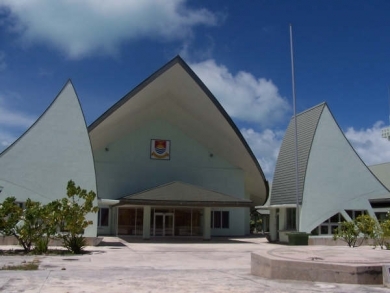
| Parliament House, Kiribati. Source: Wikimedia Commons. |
International Environmental Agreements
Kiribati is party to international agrements on: Biodiversity, Climate Change, Climate Change-Kyoto Protocol, Desertification, Hazardous Wastes, Law of the Sea, Marine Dumping, Ozone Layer Protection, and Whaling.
Water
Total Renewable Water Resources:
Freshwater Withdrawal: (domestic, industrial, agricultural)
Per Capita Freshwater Withdrawal:
Access to improved drinking water sources: 62% of population
Access to improved sanitation facilities: 33% of population
Resources
Natural Resources: phosphate (production discontinued in 1979)
Land Use:
Economy
A remote country of 33 scattered coral atolls, Kiribati has few natural resources and is one of the least developed Pacific Islands.
Although 63.6% of Kiribati’s population above the age of 15 is economically active, only 23% participate in the formal wage economy and over 60% of all formal jobs are in South Tarawa. The monetary economy of Kiribati is dominated by the services sector, representing a GDP share of 63.4%, and the public sector which provides 80% of monetary remuneration.
Commercially viable phosphate deposits were exhausted at the time of independence from the UK in 1979. The end of phosphate revenue from Banaba had a devastating impact on the economy. Receipts from phosphates had accounted for roughly 80% of export earnings and 50% of government revenue. Per capita GDP declined by more than half between 1979 and 1981. The Revenue Equalization Reserve Fund (RERF), a trust fund financed by phosphate earnings over the years, is still an important part of the government's assets and contained more than U.S. $500 million in 2009. However, with the declining returns on offshore investments in the RERF, lower drawdowns from the fund to meet fiscal deficits is vital for the long-term welfare of the country.
In one form or another, Kiribati gets a large portion of its income from abroad. Examples include fishing licenses, development assistance, tourism, and worker remittances. External sources of financing are crucial to Kiribati, given the limited domestic production ability and the need to import nearly all essential foodstuffs and manufactured items. Historically, the I-Kiribati were notable seafarers, and today about 1,400 I-Kiribati are trained, certified, and active as seafarers. Remittances from seafarers are a major source of income for families in the country, and there is a steady annual uptake of young I-Kiribati men to the Kiribati Maritime Training Institute. Remittances from Kiribati workers living abroad provide more than $11 million annually.
Copra and fish now represent the bulk of production and exports. Fishing fleets from South Korea, Japan, China, Taiwan, and the United States pay licensing fees to operate in Kiribati's territorial waters. These licenses produce revenue worth about U.S. $20 million to $35 million annually. Kiribati's exclusive economic zone comprises more than 3.55 million square kilometers (1.37 million square miles) and is very difficult to police given Kiribati's small land mass and limited means. Kiribati has only one police patrol boat. Kiribati probably loses millions of dollars per year from illegal, unlicensed, and unreported fishing in its exclusive economic zone.
The economy has fluctuated widely in recent years. Economic development is constrained by a shortage of skilled workers, weak infrastructure, and remoteness from international markets.
Tourism is a relatively small, but important domestic sector. Attractions include World War II Tarawa battle sites, game fishing, and ecotourism. The majority of American tourists only visit Christmas Island in the Line Islands on fishing and diving vacations.Tourism provides more than one-fifth of GDP.
Private sector initiatives and a financial sector are in the early stages of development.
Foreign financial aid from the EU, UK, US, Japan, Australia, New Zealand, Canada, UN agencies, and Taiwan accounts for 20-25% of GDP. Remittances from seamen on merchant ships abroad account for more than $5 million each year. Kiribati receives around $15 million annually for the government budget from an Australian trust fund. U.S. assistance is provided primarily through multilateral institutions.
Most islanders engage in subsistence activities such as fishing and growing of food crops like bananas, breadfruit, and papaya. The leading export is the coconut product copra, which accounts for about two-thirds of export revenue. Other exports include pet fish, shark fins, and seaweed. Kiribati's principal trading partners are Australia and Japan.
Transportation and communications are a challenge for Kiribati. Air Pacific is currently the only airline providing international air links to Kiribati. Air Pacific operates a twice-weekly flight from Fiji to the capital of Tarawa and has a stop on Kiritimati Island during a flight between Fiji and Honolulu. As of early February 2012, domestic airlines had ceased regular scheduled flights, and most of the populated atolls in the Gilberts were only accessible by boat or charter aircraft flying from Tarawa. Small ships serve outlying islands, including in the Line Islands, with irregular schedules. Telecommunications are expensive, and service is mediocre.
GDP: (Purchasing Power Parity): $612 million (2011 est.)
GDP: (Official Exchange Rate): $200 million (2011 est.)
GDP- per capita (PPP): $6,200 (2011 est.)
GDP- composition by sector:
agriculture: 8.9%
industry: 24.2%
services: 66.8% (2004)
Agricultural products: copra, taro, breadfruit, sweet potatoes, vegetables; fish
Industries: fishing, handicrafts
Currency: Australian dollars (AUD)
