Mato Grosso tropical dry forests
Located in central Brazil, the Mato Grosso dry forest is part of the Alto Xingu. This is an ecoregion of an extraordinary diversity of plants, animals and indigenous peoples. The region constitutes a transitional area between the Amazonian moist forest and the cerrado vegetation. A sector of great biological interest in this ecoregion is the Serra do Cachimbo, a 700 meter (m) escarpment, considered an endemic area for various species. Isolated until the construction of highways in the area in the 1970s, the region was the site of scientific expeditions before and during the 1970s. Threats to the region include gold mining, which has brought thousands of people to the area, logging, agriculture and cattle ranching.
Location and General Description
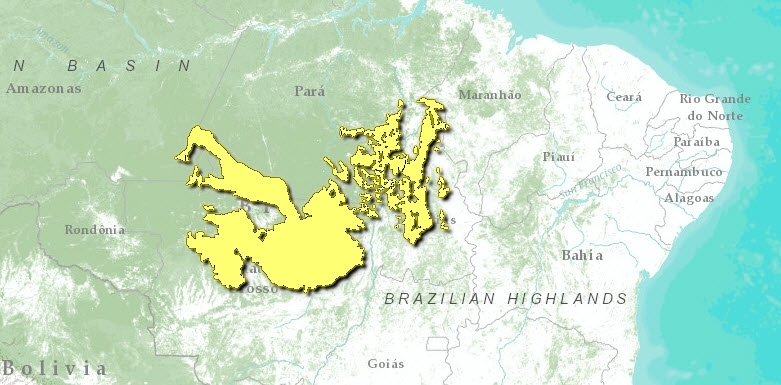
The Mato Grosso dry forests are located in the Mato Grosso and Para provinces of Central Brazil. This region is a transitional zone between the moist forests to the south and "cerrado" grassland savannas to the west; thus it hosts a great variety of habitat types such as lowland forest, savanna, gallery forests, and dense thicket areas. The ecoregion encompasses part of the Alto-Xingu, which constitutes the headwaters of the Xingu River.
The landscape elements in the region include the Serra do Cachimbo, which forms the northeastern arm, and the Serra dos Caiabis and Serra Formosa, which form the eastern arm of the region. All of these western Serras are well-drained savannas with 6-8 wet months and an average temperature of 23.5°C. The almost circular body of the ecoregion, including the patchy areas to the west, are tropical semi-evergreen season forest with 8-9 wet months and an average temperature of 23.5°C. This area contains a river system that is a drainage basin framed by the Serra do Roncador and the Serra do Formosa.
The ecoregion has a topography composed of less than 8% slopes in the south, and 8-30% of slopes in the north. The soil taxonomy in the ecoregion includes three orders. The majority of the soils in the central part and eastern patches are ultisols, the western arms of the ecoregion consist of entisols and oxisols in the Serras.
The seasonal rains define this habitat. During the flood season, from December to May, much of this area is under water and becomes a flooded forest/shrubland. These floods bring precious resources and nutrients to this region, and are essential in the lifecycles of many of its inhabitants. The rest of the year is fairly dry, and because the soil is porous, the wetlands and pools dry quickly to form massive flats and dry forest patches, as well as patches of savanna and moist forest. Fire also plays an important role in this region. All together, these habitats blend to form a unique network of forest, grass, and transitional habitat, all dependant on the annual flooding and on periodic fires.
The ecoregion is found in a transitional area between the Amazon moist forest and the Planalto cerrado. The forests are not as lush as those found in the west, but the trees are smaller (10-15 m). The flora includes forest species such as Bowdichia sp., Hymenaea sp., Machaerium sp., and Piptadenia incurialis. Some Cerrado species include Curatella american, Qualea sp., and Kielmeyera coriacea. Serra do Cachimbo is composed of white sand, and has a large area of campo ruprestre, which is an open formation on rocks that cannot retain water and suffer drought despite the humid climate. The campos look like savannas, but floristically and physiognomicaly are different. These campos have specialized formation with unique flora Some of the vegetation in this Serra includes Calea lutea and other plants characteristic of caatinga forest.
Biodiversity Features
This ecoregion is in a permanent state of natural successional change. Because of the strong seasonality and the diversity of habitat types in and around this ecoregion, wildlife is diverse and abundant. Accounts of the Mato Grosso (upper Xingu River) expedition by the Royal Society and Royal Geographical Society from 1967-69, mention that there are 46 genera of rodents including the largest of all, the capybara (Hydrochoerus hydrochaeris), 52 genera of bats, 3 of marsupials and 11 of edentates. The most common bats were Artibius and Molossus. Of the 161 birds recorded in the expedition 60 occurred exclusively in the cerrado, 33 in gallery forests, 25 in dry forest. The caatinga antwren (Herpsilochmus sellowi) has an isolated population in the Serra do Cachimbo.
Endemism is high in both plants and animals, particular among butterflies. An endemic amphibian in the Serra do Cachimbo is Tropidurus insulanus.
Current Status
The region was isolated until the construction of the Highway from Brazilia to Acre and the Cuiaba-Santarem Highway. The area has experienced a rapid human population growth due to gold rush in various towns including Peixoto de Azevedo. Where there is no gold, logging takes its place for profit. Other areas, where migrants have settled, have been cleared for agriculture and cattle ranching. The once small-frontier villages have now become big towns. Serra do Cachimbo is also an area that has been greatly affected by gold mining.
One of the protected areas in the region is Xingu National Park. This is second largest National Park in Brazil, created in 1961 as an area of protection for indigenous tribes and as natural reserve for fauna and flora. The Park contains various indigenous tribes who divided it into sixteen ethnic branches. Some of the tribes of the upper Xingu are the Auetí, Meináco, Waurá, Kamaiura, Txikao, Trumái, Kalapalo nad Matipú.
Types and Severity of Threats
The ever-increasing population in the area threatens the remaining natural [[habitat]s]. Even the Xingu National Park is threatened by fast growing towns. Gold mining and mercury pollution are severe threats. Mercury either ends up in the streams or as vapor that later falls with the rains as methyl mercury, a very toxic chemical. Other threats are the continuous expansion of agriculture and cattle ranching.
Justification of Ecoregion Delineation
The Mato Grosso forests form a vegetative transitional zone between the lowland and submontane moist forests of the Amazon Basin and the seasonal shrublands of the cerrado. Species assemblages are distinct, and climate and vegetation becomes increasingly seasonal moving south. The linework was derived from IBGE following their broad classification of "areas of ecological tension (between types of vegetation" (more specifically "savanna – ombrophilous forest", "savanna – seasonal forest", and "ombrophilous forest – seasonal forest") and includes a large patch in the western portion and becomes increasingly fragmented in the eastern portion – occurring in a mosaic patchwork of outliers within Amazonian moist forest and cerrado habitat. These forests are distinct in that they form a unique transitional habitat, hosting many endemic species. Further justification is offered by Silva.
Additional Information on this Ecoregion
- For a shorter summary of this entry, see the WWF WildWorld profile of this ecoregion.
- To see the species that live in this ecoregion, including images and threat levels, see the WWF Wildfinder description of this ecoregion.
- World Wildlife Fund Homepage
Further Reading
- Askew, G.P., D.J. Moffatt, R.F. Montgomery, and P.L. Searl. 1970a. Interrelationships of soils and vegetation in the savanna-forest bourdary zone of north-eastern Mato Grosso. The Geographical Journal, 136:370-376.
- Askew, G.P., D.J. Moffatt, R.F. Montgomery, and P.l. Searl. 1970b. Soil landscape in north eastern Mato Grosso. The Geographical Journal, 136:211-227.
- Cochrane, T.T., L.G. Sanchez, L.G. De Azevedo, J.A. Porras, and C.L. Garver. 1985. Land in Tropical America Vol. 1. Centro Internacional de Agricultura Tropical, Colombia.
- Davis, S.D., V.H. Heywood, O. Herrera-MacBryde, J. Villa-Lobos, and A.C. Hamilton, editors. 1997. Centres of plant diversity: A guide and strategy for their conservation, Vol. 3 The America. IUCN, WWF, Oxford, U.K.
- Eiten, G. 1982. Brazilian "Savannas". Pages 25-47 in B.J. Huntley and B.H. Walker, editors. Ecology of tropical savannas. Springr-Verlag, New York.
- Fundação Instituto Brasilero de Geografia Estatástica-IBGE. 1993. Mapa de vegetação do Brasil. Map 1:5,000,000. Rio de Janeiro, Brazil.
- Furley, P.A., J.A. Ratter, and D.R. Gifford. 1978. Observation on the vegetation of eastern Mato Grosso, Brazil. III. The woody vegetation and soils of the Morro de Fumaça, Torixoreu. Proc. R. Soc. Lond., B203:191-208.
- Margolis, M. 1992. The Last New World: The conquest of the Amazon Frontier. WW Norton & Company, N.Y. ISBN: 0393033791
- Murça Pires, J. and Ghillean T. Prance. 1985. The vegetation types of the Brazilian Amazon. In G.T. Prance and Thomas E. Lovejoy, editors. Key Environments: Amazonia. Pergamon Press, Oxford.
- Novaes, F.C., and M.d.F.C. Lima. 1991. As aves do Rio Peixoto de Azevedo, Mato Grosso, Brasil. Revta bras. Zool., 7:351-381.
- Oliveira-Filho, A.T., and J.A. Ratter. 1995. A study of the origin of Central Brazilian forests by the analysis of plant species distribution patterns. Edinb. J. Bot., 52:141-194.
- Pires, J.M., and G.T. Prance. The vegetation types of the Brazilian Amazon. Pages 109-145 in G.T. Prance and T.E. Lovejoy, editors. Key environments Amazonia. Pergamon Press, Oxford.
- Ratter, J.A. 1992. Transitions between cerrado and forest vegetation in Brazil. Pages 417-429 in P.A. Furley, J. Proctor and J.A. Ratter, editors. Nature and dynamics of forest - savanna boundaries. Chapman & Hall, London.
- Ratter, J.A., P.W. Richards, G. Argent, and D.R. Gifford. 1973. Observations on the vegetation of northeastern Mato Grosso I. The woody vegetation types of Xavantina - Cachimbo expedition area. Philosophical Transactions of the Royal Society of London, 266:449-492.
- Secretaria de Planejamento e Coordenação da Presidencia da Republica. 1988. Mapa de Vegetacao do Brasil. Secretaria de Planejamento e Coordenação da Presidencia da Republica, Fundação Instituto Brasileiro de Geografia e Estatistica Ministerio da Agricultura., Rio de Janeiro, Brasil.
- Silva, J.M.C. 1998. Un métedo para o estabelecimento de äreas prioritrias para a conservação na Amazönia legal. Report prepared for World Wildlife Fund – Brazil. 17 pp.
- Smith, Anthony. 1971. Mato Grosso: Last Virgin Land. An account of the Mato Grosso based on the Royal Society and Royal Geographical Society expedition to central Brazil 1967-9. Dutton, N.Y.
- UNESCO. 1981. Vegetation Map of South America: Explanatory Notes. UNESCO, Paris.
- Villas Boas, O., and C. Villas Boas. 1973. Xingu: The Indians, their Myths. K.S. Brecher, editor. Farrar, Straus and Giroux, N.Y.
- Whitney, Bret M., Pacheco, J.F., Buzzetti, D.R. and Ricardo Parrini. 2000. Systematic revision and biogeography of the Herpsilochmus pileatus complex, with description of a new species from northeastern Brazil. The Auk 117 (4): 869-891
| Disclaimer: This article is taken wholly from, or contains information that was originally published by, the World Wildlife Fund. Topic editors and authors for the Encyclopedia of Earth may have edited its content or added new information. The use of information from the World Wildlife Fund should not be construed as support for or endorsement by that organization for any new information added by EoE personnel, or for any editing of the original content. |

