Martinique
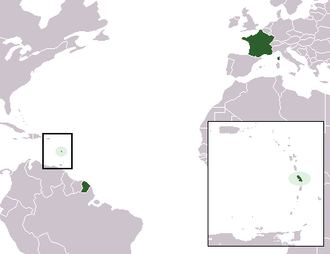 Location of Martinique in relation to France and French Guiana. Source: Wikipedia
 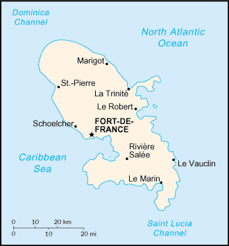 Martinique. Source CIA World Factbook
 Martinique is an island in the eastern Caribbean Sea, south of Dominica and north of Saint Lucia. It is one of the Windward Islands of the Lesser Antilles and part of the Caribbean/West Indies. It is an overseas department of France. To the northwest lies Dominica, to the south St Lucia. As with the other overseas departments, Martinique is also one of the twenty-six regions of France (being an overseas region) and an integral part of the Republic.
Colonized by France in 1635, the island has subsequently remained a French possession except for three brief periods of foreign occupation.
Contents
Geography
Location: eastern Caribbean Sea. To the northwest lies Dominica, to the south St Lucia
Geographic Coordinates: 14 40 N, 61 00 W
Area: 1,100 square km (1,060 sq km of land and 40 sq km of water]]
arable land: 10%
permanent crops: 11%
other: 79% (1998 est.)
Coastline: 350 km
Maritime Claims: territorial sea: 12 nautical miles and an exclusive economic zone to 200 nautical miles.
Natural Hazards: Hurricanes, flooding, and volcanic activity (an average of one major natural disaster every five years). Mount Pelee, erupted on 8 May 1902 and completely destroyed the city of Saint Pierre, killing 30,000 inhabitants.
Terrain: Mountainous with indented coastline and a dormant volcano, Montagne Pelee (Mount Pelee) (1,397 meters). The north of the island is mountainous and lushly forested. It features 4 ensembles of pitons and mornes: the Piton Conil on the extreme North, which dominates the Dominica Channel, the Mount Pelee, an active volcano, the Morne Jacob, and the Pitons du Carbet, an ensemble of 5 rainforest-covered extinct volcanoes dominating the Bay of Fort de France at 1,196 meters. The most dominating of the island's many mountains, with 1397 meters, is the infamous volcano Mount Pelée. The volcanic ash has created grey and black sand beaches in the north (in particular between Anse Ceron and Anse des Gallets), contrasting markedly from the white sands of Les Salines in the south.The south is more easily traversed, though it still features some impressive geographic features. Because it is easier to travel and because of the many beaches and food throughout this region, the south receives the bulk of the tourist traffic. The beaches from Pointe de Bout, through Diamant (which features right off the coast of Roche de Diamant), St. Luce, the town of St. Anne all the way down to Les Salines are popular.
Climate: Tropical; moderated by trade winds; rainy season (June to October); vulnerable to devastating cyclones (hurricanes) every eight years on average; average temperature 17.3 degrees C; humid
Capital: Fort-de-France
Ecology and Biodiversity
Windward Islands moist forests
Moist forests dominate Martinique, covering most of the island. The forests of this ecoregion are some of the most biologically rich and diverse in the Lesser Antilles, if not the entire Caribbean. Steep mountains inhibit extensive human-related development while abundant annual rainfall has allowed for great floral and faunal diversity. [Martinique]] has some of the Caribbean’s largest forest tracts though much is secondary.
This dry forest ecoregion is sparsely distributed among the Windward Island Group of the Caribbean’s Lesser Antilles. It is commonly found as an intermediate gradient between the moister, high-elevation forests and the xeric, coastal areas. By virtue of its proximity to the Windward Islands moist forests, which is very high in terms of biological richness and diversity, this ecoregion also has abundant floraand fauna. Due to its restricted size, distribution and similarity to the moist forest ecoregion however, little information exists regarding plants and animals specific only to this area. The Martinique Oriole is endemic to the island's dry forests.
Martinique, since 1953, is subject to the same legislation as metropolitan France, producing a lot of conservation involvement at the local level by French non-governmental organizations (NGOs). Yearly revisions to French legislation are produced by the Direction de la Protection de la Nature on Martinique.
Martinique Regional Park (702 square km) places most of the island under protected status.
People and Society
Population: 422,277 (July 2002 est.)
Age Structure:
0-14 years: 23% (male 49,261; female 47,843)
15-64 years: 66.8% (male 140,616; female 141,460)
65 years and over: 10.2% (male 19,274; female 23,823) (2002 est.)
Population Growth Rate: 0.89% (2002 est.)
Birthrate: 15.37 births/1,000 population (2002 est.)
Death Rate: 6.4 deaths/1,000 population (2002 est.)
Net Migration Rate: -0.07 migrant(s)/1,000 population (2002 est.)
Life Expectancy at Birth: 78.56 years
Total Fertility Rate: 1.79 children born/woman (2002 est.)
Languages: French, Creole patois
Literacy: 93%
Economy
The economy is based on sugarcane, bananas, tourism, and light industry. Agriculture accounts for about 6% of Gross Domestic Product (GDP) and the small industrial sector for 11%. Sugar production has declined, with most of the sugarcane now used for the production of rum. Banana exports are increasing, going mostly to France. The bulk of meat, vegetable, and grain requirements must be imported, contributing to a chronic trade deficit that requires large annual transfers of aid from France. Tourism, which employs more than 11,000 people, has become more important than agricultural exports as a source of foreign exchange. The majority of the work force is employed in the service sector and in administration.
GDP: (Purchasing Power Parity): $4.39 billion (1997 est.)
GDP- composition by sector:
agriculture: 6%
industry: 11%
services: 83% (1997 est.)
Industries: construction, rum, cement, oil refining, sugar, tourism
Natural resources: coastal scenery and beaches, cultivable land
Currency: Euro