Physiography of the ocean basins
| Topics: |
Geology (main)
|
Contents
Origin of the Ocean Basins
The ocean basins are the result of tectonic forces and processes. All of the ocean basins were formed from volcanic rock that was released from fissures located at the mid-oceanic ridges. The oldest rocks found in these basins are approximately 200 million years old. This is a lot younger than the oldest continental rocks which have ages greater than 4 billion years. The reason for this discrepancy is simple—tectonic processes destroy old oceanic rocks. Oceanic rock is returned to the Earth's mantle when oceanic crust is subducted. Many of these subduction zones occur at the continental margins where oceanic crust meets continental crust. Subduction also creates the ocean's deep trenches.
Topography of the Ocean Basins
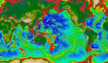 Figure 1: The following image displays the topography of the Earth's terrestrial land surface and ocean basins. (Modified from image available at the Seafloor Topography Website, Institute of Geophysics and Planetary Physics, University of California at San Diego).
 The ocean basins are not featureless Earth surfaces (Figure 1). Much of our knowledge about the topographic features that exist here are derived from the following technologies: seismic surveying; echo sounder; side-scan sonar; and the measurement of the height of sea surfaces by satellites. Most of the general information concerning the depth of the ocean basins were made after World War I when the echo sounder was developed for military purposes. This instrument accurately determines the time between the emission of a strong acoustic pulse and the detection of its echo. Using this principle scientists can determine the distance from the sounder to the ocean bottom.
Figure 1 displays the topography of the Earth's terrestrial land surface and ocean basins. Data for the image comes from satellite altimetry and ship depth soundings, and U.S. Geological Survey digital elevation maps (DEM) of the Earth's land surface. In the ocean basin, the gradation from red to yellow to green to blue indicates increasing depth. A number of topographic features associated with the ocean basin can be seen in this image. The red area that borders the various landmasses is the Continental Shelf. This feature is structurally part of the continental landmasses despite the fact that it is under water. The yellow to green zone around the continental shelf is the continental slope and continental rise. The blue region in the various ocean basins constitutes the ocean floor. In the center of ocean basins, the mid-oceanic ridges can be seen with a color ranging from green to yellow to orange.
Some of the dominant topographic features associated with the ocean basins include:
- The Continental Shelf is a shallow (average depth 130 meters), gently sloping part of the continental crust that borders the continents (see Figure 1 and Figure 2). The extent of this feature varies from tens of meters to a maximum width of about 1,300 kilometers.
- The continental slope extends from the continental shelf at an average depth of about 135 meters (see Figure 2). The base of this steeply sloping (from 1 to 25°, average about 4°) topographic feature occurs at a depth of approximately 2,000 meters, marking the edge of the continents. The width of the slope varies from 20 to 100 kilometers. Both the continental shelf and slope are considered structurally part of the continents, even though they are below the sea surface. The boundary between the continental slope and shelf is called the continental shelf break.
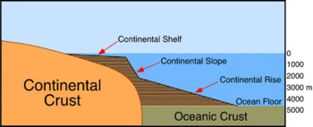 Figure 2: Marginal features found at the interface of the continents and the ocean basins. (Source: PhysicalGeography.net)
 - Submarine canyons are V-shaped canyons cut into the continental slope to a depth of up to 1,200 meters. The submarine canyons are cut perpendicular to the running direction of the continental slope. Many canyons are associated with major rivers such as the Congo, Hudson, and others.
- The continental rise is found at the base of the continental slope (see Figure 1 and Figure 2). The depth of the rise ranges from 2,000 to 5,000 meters deep. Its breadth is up 300 kilometers wide. This feature was created by the merging of accumulated deposits at the mouths of the many submarine canyons. Each canyon's thick, fan-shaped sedimentary deposit is called an abyssal fans.
- The ocean floor is found at the base of the continental rise in water 4,000 to 6,000 meters deep (see Figure 1). The ocean floor accounts for nearly 30% of the Earth's surface. The composition of the ocean floor consists of a relatively thin layer (on average 5 kilometers thick) of basaltic rock with an average density of 3.0 grams per cubic centimeter (continents - granite rocks - density 2.7 grams per cubic centimeter).
- Numerous volcanoes populate the floor of the ocean basins. Scientists estimate that there are approximately 10,000 volcanoes on the ocean floor.
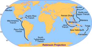 Figure 3: Major ocean trenches of the world. The Mariana Trench is the deepest at 11,020 meters below sea-level. (Source: PhysicalGeography.net)
 - The mid-oceanic ridge is normally found rising above the ocean floor at the center of the ocean basins (see Figure 1). These features are involved in the generation of new oceanic crust from volcanic fissures produced by mantle up-welling. Some volcanic islands are part of the mid-ocean ridge system (e.g., Iceland). The mid-oceanic ridge constitutes 23% of the Earth's surface. In the center of the mid-oceanic ridge is a rift valley, between 30 to 50 kilometers wide, that dissects 1,000 to 3,000 meters deep into the ridge system.
- Ocean trenches are long, narrow, steep-sided depressions found on the ocean floor that contain the greatest depths in the ocean (11,000 meters - western Pacific). There are 26 oceanic trenches in the world: 3 in the Atlantic Ocean, 1 in the Indian Ocean, and 22 in the Pacific Ocean (Figure 3). Generally, the trenches mark the transition between continents and ocean basins, especially in the Pacific basin. Trenches are also the tectonic areas.
Ocean Basin Configuration
The current spatial configuration of the ocean basins is a by-product of plate tectonics. The creation of new oceanic crust at the mid-oceanic ridge moves the continents across the Earth's surface and creates zones of subduction. At the areas of subduction, oceanic crust is forced into the mantle after it collides with continental crust. Over the past 200 million years, the Atlantic basin has been the most active area of oceanic crust creation. The Atlantic Ocean formed about 200 million years ago as the Pangaean continent began rifting apart. 180 million years ago, North America separated from South America and Africa. North America then joined with Eurasia creating Laurasia. By 135 million years ago, South America began separating from Africa. North America and Eurasia split a few million years after.