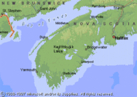
Lake Kejimkujik, Nova Scotia
| Topics: |
Physical Attributes
- Altitude: 90 m above sea level
- Surface Area: 26.3 sq. km
- Mean Depth: 4 m
- Maximum Depth: 19.2 m
- Volume: 0.106 cu. km
- Shoreline Length: 45 km
- Drainage Basin: 289 sq km
General Description
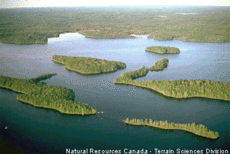
Kejimkujik Lake is located in central Nova Scotia within Kejimkujik National Park. This freshwater lake is close to the ocean (60 km inland from the Atlantic Ocean and 40 km inland from the Bay of Fundy) and is consequently slightly salty. Water flows into the lake out of peatlands and has high levels of humic acids. Mersey River is the main outflow from the lake. Kejimkujik Lake is oligotrophic, shallow and does not develop a hypolimnion during the summer. This lake is dimictic and is frozen from the end of December to mid-April. Several small islands on the lake comprise a total area of 1.97 sq km. Since Kejimkujik Lake naturally has a low buffering capacity and acidic waters, acid rain resulting from the long range transport of pollutants has caused serious damage to this ecosystem. The pH of the lake is chronically depressed (4.8 annual mean) and as a result, salmon populations downstream of the lake have collapsed due to reproductive failure.
Watershed
Kejimkujik Lake is found on Devonian granite bedrock. The drainage basin is 99% covered by forest, bogs and lakes.