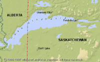
Lake Athabasca, Alberta/Saskatchewan
| Topics: |
Physical Attributes
- Altitude: 213 m above sea level
- Surface area: 7,770 sq. km
- Mean depth: 20 m
- Maximum depth: 124 m
- Volume: 155 cu. km
- Shoreline length: 2,140 km
- Drainage Basin: 158,000 sq. km
General Description
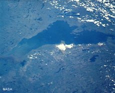
Lake Athabasca is Canada's eighth largest lake. Approximately 70% of the lake lies within Saskatchewan and the balance is in Alberta. The major water sources are the Athabasca (53%) and Fond du Lac (21%) Rivers. The lake is drained by Riviere des Rochers, its distributary Revillon Coupe, and Chenal des Quatre Forches, all of which join the Peace River to form the Slave River. The Peace-Athabasca Delta, located at the southwestern end of the lake, is one of the world's largest freshwater deltas and is a major wetland area. The shallow lakes and channels associated with the delta are also important spawning areas for lake trout, Arctic grayling, lake whitefish, goldeye, northern pike, yellow perch and walleye. Lake Athabasca also supports large populations of waterfowl and fur-bearing animals. Lake Athabasca's rugged northern shore of Precambrian Shield contrasts with the southern shores characterized by a large area of sand dunes. There are numerous islands throughout the lake, some of which were formed by wave action. Athough the lake is very transparent with low algal concentrations, its recreation value is low compared to other lakes in the area because of its cold temperatures and high waves.
Watershed
The Lake Athabasca drainage basin encompasses an area of 282 000 sq. km that extends from the Columbia Icefield in the Rocky Mountains northeast across Alberta and northern Saskatchewan to Wollaston Lake. The land ranges from flat to mountainous and is mostly covered by forest, bush and wetlands. The bedrock is sandstone or granite and soil types include Grey Luvisols, Fibrisols, Cumulic Regosols, and Humo-Ferric Podzols. Dominant vegetation is trembling aspen, balsam poplar and white spruce. While forestry is the major industry in the Alberta side of the watershed, mining for gypsum, granite, gold and uranium is clustered on the Saskatchewan side. Agriculture is concentrated in the southwestern reaches of the drainage region.