Kachemak Bay National Estuarine Research Reserve, Alaska
Introduction
The Kachemak Bay Research Reserve (KBRR) is the only fjord in the National Estuarine Research Reserve (NERR) System, which includes 27 estuaries nationwide. Like other NERRs, the KBRR emphasizes long-term ecological research and education. Kachemak Bay is one of the most productive, diverse, and intensively used estuaries in Alaska. The natural beauty and recreational opportunities of the Bay attract both residents and thousands of summer tourists. The local economy depends upon a lucrative fishing industry and the breathtaking scenery. Its natural, protected deep-water harbor, connection to the road system, and location in lower Cook Inlet makes Homer an ideal connection to the Alaska Marine Highway, loading of cargo, and pilot transfer to vessels traveling up Cook Inlet.
Kachemak Bay was federally designated by the National Oceanic and Atmospheric Administration (NOAA) as a National Estuarine Research Reserve on February 12, 1999. The research reserve boundary includes areas of land and water that were owned by the public prior to its designation. Designation of the Kachemak Bay Reserve does not change existing ownership, regulations or management authority, nor does it result in any additional regulations. The reserve's research and education programs extend beyond the designated boundaries to include the surrounding watershed for the Bay, as well as other areas that may benefit from reserve programs.
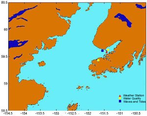
The Reserve includes approximately 4,000 km2 (365,000 acres) of terrestrial and marine habitats, making it the largest reserve in the NERR system. The Reserve extends from the Fox River Flats at the head of the Bay to Point Pogibshi and Anchor Point at the mouth. The bathymetry is characterized by a submerged moraine or sill at the mouth of the Bay and deep trenches and holes extending to almost 200 meters (m) deep within the Bay. The Bay is separated into an inner and outer bay by a 6 km long spit extending south from the village of Homer (pop. 5,000). This relict moraine restricts the surface circulation in the Bay. The south side of the bay is mostly rocky and lined by rugged, snow-covered mountains. Because the tree-line elevation at this latitude is only 500 m, the 2000 m alpine summits resemble those of much loftier mountain ranges.

Seven glaciers flow into Kachemak Bay from the Harding and other ice fields, some of the last remaining ice fields in North America. The large volume of sediments derived from these glaciers help build and sustain the predominantly sand and gravel beaches surrounding the estuary. The Fox River Flats, at the head of the bay, is a huge salt marsh complex supporting thousands of migratory birds every spring and fall. During the summer, glacier meltwater contributes approximately 70,000 cubic meters of fresh water each day to the inner Bay. Another 14 billion cubic meters of cold, nutrient-rich seawater from the Gulf of Alaska flows in and out of the outer Bay, partly driven by an amazing 8.7 meter tidal range that results from the complex geomorphology of the Gulf of Alaska and Cook Inlet.
Fjords such as Kachemak Bay often have a seasonally stratified water column that results when a surface layer of fresh water develops above denser cold seawater. But one unique feature of this high-latitude NERR is that during the 6-month long winter, when the watershed is frozen, this fresh surface layer disappears and the bay becomes wholly marine. Interestingly, an annual decrease in benthic biological diversity accompanies this shift from a marine to an estuarine system. But because many of the marine mammals, birds, and fishes in the Bay are migratory, the overall annual diversity is still very high compared to similar systems further south.
Research
KBRR scientists are leading efforts at the local, regional, and national levels to understand the interrelationships between oceanic, nearshore and watershed environments. Kachemak Bay and the Gulf of Alaska provide a nearly pristine living laboratory for large-scale spatial and temporal studies of these diverse yet interconnected systems. Reserve scientists are studying the physical and biological processes that cause short-term variability and long-term changes. Examples of our research interests include:
- Biodiversity and Community Structure. The KBRR is monitoring changes in intertidal and subtidal biological communities and population interactions. Communities being studied include kelp beds, invertebrates, algae, fishes, and marine mammals.
- Physical Forcing Mechanisms. The Reserve is conducting research on the effects of physical oceanic and atmospheric forcing mechanisms that help to determine spatial and temporal patterns of biological populations and communities. The sheer magnitude of physical processes in Kachemak Bay, such as the tidal and estuarine flushing described above, lends itself to such scientific studies. For example, because water circulation and hydrography are very important in determining biological activity in Kachemak Bay, KBRR scientists are studying the spatial and temporal variation of primary productivity relative to estuarine circulation and mixing dynamics in the Bay.
- Biogeochemical Cycling. Primary productivity, nutrient uptake and organic cycling in the Bay are closely tied to physical and biological processes involving biogeochemical cycling. Reserve scientists are studying ways in which nutrients and other materials are cycled in order to help resource managers better understand what natural processes they should protect.
- Watershed Land Use Impacts. Changes in watershed vegetation cover have occurred due to development, spruce bark beetle infestations, logging and forest fires. KBRR scientists are studying how these watershed changes may affect nutrient cycling, habitat quality, and biological communities in the Reserve.
The KBRR is developing a science program with a vision to becoming the leading research facility for the Lower Cook Inlet and surrounding Gulf of Alaska waters. The program boundaries extend to the east as far as the Pye Islands in Kenai Fjords National Park, to the south as far as Shuyak Island in the Kodiak Archipelago, to the west across Shelikof Strait and Cook Inlet, and to the north as far as Kenai.
The KBRR facilities provide an excellent geographic location to access and monitor the waters flowing from the Gulf of Alaska into Cook Inlet, as well as those waters flowing into Shelikof Strait. Kachemak Bay is an ideal site for year-around instrument testing, long-term deployments, and protocol development and the science staff can provide on-site expertise on many advanced technologies, instrumentation, and protocols.
Partners and Supporters
The reserve is managed in partnership by the National Oceanic and Atmospheric Administration and the Alaska Department of Fish and Game with assistance from a research and education advisory group. The reserve partners with the Alaska Department of Natural Resources, University of Alaska, U.S. Fish and Wildlife Service, several non-profits and local governments.
Further Reading