Jobos Bay National Estuarine Research Reserve, Puerto Rico
Contents
Introduction Jobos Bay Reserve boundary map. (Source: NERRS (Jobos Bay National Estuarine Research Reserve, Puerto Rico) )
The Jobos Bay Reserve is one of 27 reserves in the National Estuarine Research Reserve System (NERRS), a network of estuarine habitats protected and managed for the purposes of long-term research, education, and coastal stewardship. It is the second largest estuarine area in Puerto Rico, encompassing a chain of 15 tear-shaped mangrove islets known as Cayos Caribe and the Mar Negro area in western Jobos Bay.
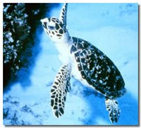
The reserve is home to the endangered brown pelican, peregrine falcon, hawksbill sea turtle and West Indian manatee. It is commercially important for marine recreation, commercial and recreational fishing (Marine fisheries) and ecotourism.
Site Description
The Jobos Bay Reserve is made up of subtropical dry forest, coral reefs, fringing and basin mangrove forest, seagrass beds, mangrove channels, salt and mud flats, lagoons and freshwater wetlands.
Biodiversity
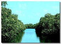
Dominant ecosystems in Jobos Bay are the mangroves. All four Caribbean species of mangrove are found here. The red mangrove forms a fringe forest close to the water, the black and white mangroves grow behind the red mangrove zone, where the tide inundates the area. Further inland you find buttonwood mangrove, palms, swamp ferns, cattails and other freshwater vegetation.
The West Indian manatee is known to forage within the Jobos Bay and Mar Negro area. The Hawkbill sea turtle has been seen near the seagrass beds. Mar Negro serves as nesting grounds for native and migratory birds such as, the yellow-shouldered blackbird, the brown pelican and various wading birds.
Threatened species found at the reserve include the West Indian manatee, the Hawksbill sea turtle and the Yellow-shouldered blackbird.
Tidal Range
One of the major characteristics of the tides in the Caribbean is their small vertical range. The mean tidal level is at +0.5 ft. above mean low water (MLW). Tide table data shows a mean high water level of + 1.0 ft. above MLW and the extreme low water level at - 1.0 ft. MLW
Soil Types
Lagoon and swamp deposits cover most of the surface of the reserve. They consist of unconsolidated clay, silt and organic matter. These deposits are covered almost entirely by mangroves. Beach deposits occur along the islets of Cayos Caribe. They are composed of sand, gravel, volcanic rock cobbles and shell fragments. Alluvial plain deposits dominate over the northern part of the Reserve and consist of unconsolidated sand, gravel and pebbles.
Geology
Jobos Bay Reserve is mostly located in the Central Aguirre quadrangle. All of the superficial unconsolidated deposits within the reserve are mainly Quaternary in age and consist of lagoon, swamp, beach and alluvial deposits.
An ancient inactive fault, known as the Esmeralda Fault, runs in a northwest-southeast direction north of Jobos Bay. A projection of the fault suggests that it probably passes under Jobos Bay towards the Caribbean Sea. Calcite deposits tightly seal this system below weathering penetration.
There are no metallic mineral deposits of commercial value in the general area of the reserve. Small amounts of hematite are found several kilometers northeast of Jobos Bay.
Cultural History
The reserve's history dates back to the Arcaico and Taino Indians. Archaeological sites of both groups have been found and studied in the area. Attacks of the Caribe Indians are dated to 1567.
Later the Spaniards colonized the area taking advantage of its excellent port and salines. Important pirates such as Cofresi are mentioned passing through the bay.
In 1899, the Aguirre Sugar Plant Mill was established on the west side of Jobos Bay. This industry was the beginning of the growth of an independent town with its own history. Attracted by its magnificent port and other industries, such as oil refineries, thermoelectric plant and pharmaceuticals, were established in the area. By 1980, the Aguirre Corporation had ceased operating and was in the process of liquidation.
In 1981, the reserve was designated to include what is now known as the Mar Negro mangrove forest (Lugo Viñas farm) and Cayos Caribe islets.
Partners
The Puerto Rico Department of Natural and Environmental Resources manages Jobos Bay Reserve. The reserve is engaged in cooperative programs with the University of Puerto Rico, the Puerto Rico Sea Grant Program and other educational institutions, non-government organizations and fishery associations.
Further Reading
| Disclaimer: This article is taken wholly from, or contains information that was originally published by, the National Oceanic and Atmospheric Administration. Topic editors and authors for the Encyclopedia of Earth may have edited its content or added new information. The use of information from the National Oceanic and Atmospheric Administration should not be construed as support for or endorsement by that organization for any new information added by EoE personnel, or for any editing of the original content. |