Jersey
| Topics: |
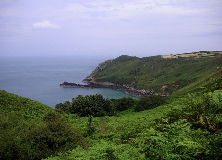
Coastline of Jersey. Source: Wikimedia Commons
Officially known as the Bailiwick of Jersey, this island of about 95,000 people in the English Channel, lies northwest of France, positioned in the Bay of Mont St. Michel off the northwest coast of France.

Jersey is a British crown dependency but is not part of the UK or of the European Union. However, the UK Government is constitutionally responsible for its defense and international representation.
Together with the the islands of Bailiwick of Guernsey, Jersey is part of Channel Islands.
Jersey largest and southernmost of Channel Islands.
|
|
|
|


The economy is based largely on international financial services, agriculture, and tourism.
Jersey and the other Channel Islands represent the last remnants of the medieval Dukedom of Normandy that held sway in both France and England.
Called Caesaria in Roman times, Jersey became part of the Duchy of Normandy in 912. When William the Conqueror invaded and took the throne of England in 1066, the fortunes of Jersey then became linked to those in England, although the island manages its internal affairs through its own parliament—the States of Jersey.
These islands were the only British soil occupied by German troops in World War II.
About 30% of population is concentrated in Saint Helier
Geography
Location: Western Europe, island in the English Channel, northwest of France
Geographic Coordinates: 49 15 N, 2 10 W
Area: 116 sq km
Coastline: 70 km
Maritime Claims:
Natural Resources: arable land
Terrain: gently rolling plain with low, rugged hills along north coast. The highest point is an unnamed elevation (143 m).
Climate: temperate; mild winters and cool summers
People and Society
Population: 94,949 (July 2012 est.)
Ethnic Groups: Jersey 51.1%, Britons 34.8%, Irish, French, and other white 6.6%, Portuguese/Madeiran 6.4%, other 1.1% (2001 census)
Age Structure:
0-14 years: 16.5% (male 8,067/female 7,507)
15-64 years: 68.7% (male 32,187/female 32,485)
65 years and over: 14.8% (male 5,953/female 7,962) (2011 est.)
Population Growth Rate: 0.826% (2012 est.)
Birthrate: 11.12 births/1,000 population (2012 est.)
Death Rate: 7.56 deaths/1,000 population (July 2012 est.)
Net Migration Rate: 4.7 migrant(s)/1,000 population (2012 est.)
Life Expectancy at Birth: 81.47 years
male: 79.05 years
female: 84.04 years (2012 est.)
Total Fertility Rate: 1.66 children born/woman (2012 est.)
Languages: English 94.5% (official), Portuguese 4.6%, other 0.9% (2001 census)
Urbanization: 31% of total population (2010) growing at an annual rate of change of 0.8% (2010-15 est.)
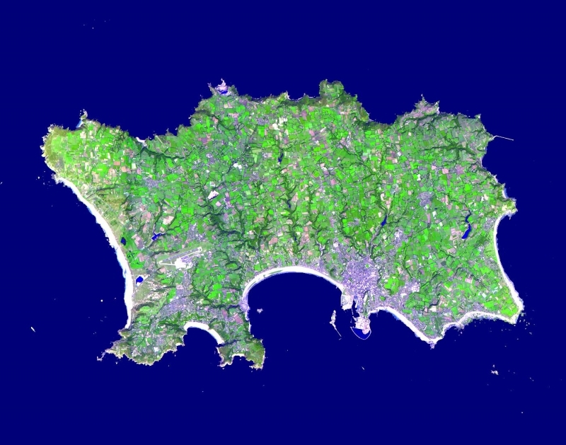
This image was acquired on September 23, 2000, by the Advanced Spaceborne Thermal Emission and Reflection Radiometer (ASTER) on NASA’s Terra satellite. With its 14 spectral bands from the visible to the thermal infrared wavelength region, and its high spatial resolution of 15 to 90 meters (about 50 to 300 feet), ASTER images Earth to map and monitor the changing surface of our planet.. Source: NASA
Government
Dependency Type/Government Type: British crown dependency/parliamentary democracy
Capital: Saint Helier
|
Administrative divisions: none (British crown dependency); there are no first-order administrative divisions as defined by the US Government, but there are 12 parishes:
|
|

Legal System: the laws of the UK, where applicable, apply; local statutes
Source: NASA/Wikimedia Commons
Economy
Jersey's economy is based on international financial services, agriculture, and tourism.
In 2005 the finance sector accounted for about 50% of the island's output. P
otatoes, cauliflower, tomatoes, and especially flowers are important export crops, shipped mostly to the UK.
The Jersey breed of dairy cattle is known worldwide and represents an important export income earner. Milk products go to the UK and other EU countries.
|
|
|
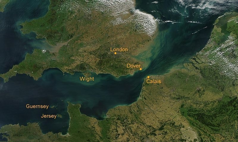
Jersey is seen in the lower right of this image of the English Channel and Celtic Sea. The milky white or turquoise hues in the color of the Celtic Sea is due to Coccoliths. Coccolithophores are a group of phytoplankton that are identifiable from space. These microscopic plants armor themselves with external plates of calcium carbonate. The plates, or coccoliths, give the ocean a milky white or turquoise appearance during intense blooms. This natural-color view of the Celtic Sea and English Channel was taken by the Multi-angle Imaging SpectroRadiometer on NASA's Terra satellite on June 4, 2001. Source: NASA |
Tourism accounts for one-quarter of GDP. In recent years, the government has encouraged light industry to locate in Jersey with the result that an electronics industry has developed, displacing more traditional industries.
All raw material and energy requirements are imported as well as a large share of Jersey's food needs.
Light taxes and death duties make the island a popular tax haven.
Living standards come close to those of the UK.
GDP: (Purchasing Power Parity): $5.1 billion (2005 est.)
GDP: (Official Exchange Rate): $5.1 billion (2005 est.)
GDP- per capita (PPP): $57,000 (2005 est.)
GDP- composition by sector:
Agricultural products: potatoes, cauliflower, tomatoes; beef, dairy products
Industries: tourism, banking and finance, dairy, electronics
Currency: Jersey pounds