Isla del Coco Marine and Terrestrial Conservation Area, Costa Rica
Contents
- 1 Introduction Isla del Coco Marine and Terrestrial Conservation Area (Area de Conservación Marina y Terrestre Isla del Coco) (5°32'N, 86°59'W) is a World Heritage Site in Costa Rica (Isla del Coco Marine and Terrestrial Conservation Area, Costa Rica) .
- 2 Geographical Location
- 3 Date and History of Establishment
- 4 Area
- 5 Land Tenure
- 6 Altitude
- 7 Physical Features
- 8 Climate
- 9 Vegetation
- 10 Fauna
- 11 Cultural Heritage
- 12 Local Human Population
- 13 Visitors and Visitor Facilities
- 14 Scientific Research and Facilities
- 15 Conservation Value
- 16 Conservation Management
- 17 IUCN Management Category
- 18 Further Reading
Introduction Isla del Coco Marine and Terrestrial Conservation Area (Area de Conservación Marina y Terrestre Isla del Coco) (5°32'N, 86°59'W) is a World Heritage Site in Costa Rica (Isla del Coco Marine and Terrestrial Conservation Area, Costa Rica) .
Geographical Location
The nominated World Heritage Site includes the entire Isla del Coco and the marine ecosystems up to a distance of 15 kilometers (km) around the island. Isla del Coco is located 555 km south-west off the Pacific coast of Costa Rica, and belongs to the Province of Puntarenas. The central point of Isla del Coco Marine and Terrestrial Conservation Area (CIMTCA) lies at 5°32'N, 86°59'W.
Date and History of Establishment
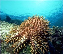 The crown-of-thorns starfish (Acanthaster planci) was one of the few animals that survived the 1982/1983 El Niño, although 90% of the coral reefs died. (Source: University of Michigan Museum of Zoology)
 Isla del Coco was designated as a National Park by Executive Decree No. 08748-A of 1978. In 1982, the status of the Island as a protected area was reinforced by Law No. 6794. In 1991, Executive Decree 20260 extended the Park's limits to include the marine ecosystems up to a distance of 15 km around the island. The entire area was declared as zone of "absolute protection", where extraction of marine resources, as well as any commercial, industrial or agricultural activities are banned. In 1995, both the marine and terrestrial components were granted the category of Conservation Area by Executive Decree No. 24652. Inscribed on the World Heritage List in 1997.
Area
Totals 99,700 hectares (ha), of which 2,400 ha corresponds to Isla del Coco, and 97,300 ha comprising surrounding marine ecosystems.
Land Tenure
State owned.
Altitude
Sea floor to 634 meters (m) (Cerro Iglesias).
Physical Features
The Cocos Ridge extends in a south-westerly direction from Costa Rica almost to the Galápagos Archipelago, Isla del Coco being the only portion to appear above sea level. The island is of volcanic origin consisting of basaltic rock and (tuffacious) breaches affected by tracheytic intrusions. It presents a rugged relief characterized by an irregular [[coast]line] with cliffs rising almost vertically from a narrow shore to heights of 200 m. There are two bays (Bahía Wafer and Bahía Chatham) with sandy beaches. Inland, the terrain is mountainous with numerous rivers and streams, many of which plunge over the peripheral cliffs in spectacular waterfalls. The Genio and Pittier rivers are the largest watercourses, draining their waters from the mountains of the interior and flowing into Bahía Wafer. The Lievre Creek flows into Bahía Chatham. Cerro Iglesias (634 m) is the highest peak in the island. Soils are very acidic entisols.
The underwater profile consists of stepwise shelves with almost no intertidal zone and a shallow submerged fringing reef, culminating in sand and Porites rubble at the edge of a several hundred meters deep trench. The most important reefs are located in Punta María, Punta Presidio, Punta Pacheco and some areas of the Iglesias, Chatham and Wafer Bays. The southern and southwestern sectors show the greatest bathymetric variation in the area, with emergent small islands (such as Dos Amigos, Rafael and Juan Bautista), and a great number of submerged rocks.
Climate
rainfall throughout the year (almost 7,000 millimeters (mm)) with a short, relatively dry season from January to March.
Vegetation
As other oceanic islands, Isla del Coco presents an impoverished flora with respect to that of the continent, but with a high number of endemic species (at least 70 species of vascular plants). The vegetation is exuberant and owes its lushness to the heavy [[rainfall]s] and rugged relief, which favors condensation. Major vegetation type corresponds to Holdridge premontane rain forest life zone. Gómez distinguished two plant associations growing on the island: i) a coastal, mostly herbaceous zone which rises between 0-50 m; and ii) a montane cloud forest zone which grows from 100 m upwards. A total of 235 species of vascular plants were recorded. The predominant tree species include the endemics huriki Sacoglottis holdridgei, Ocotea insularis and Cecropia pittieri. Undergrowth in the forest is dense with an abundance of Hypolitrum amplum, and several species of ferns. Around 25 species of moss, 27 liverworts, and 85 fungi have also been identified.
Fauna
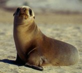 The California sea lion (Zalophus californianus) is a common marine mammal on the Isla del Coco. (Source: National Marine Fisheries Service)
 There is a rather low diversity of terrestrial fauna. Some 87 bird species have been recorded in the nominated site including three endemics, Cocos Island cuckoo Coccyzus ferrugineus, Cocos Island flycatcher Nesotriccus ridgwayi and Cocos Island finch Pinaroloxias inornata. Red-footed booby Sula sula and brown booby S. leucogaster, great frigate bird Fregata minor, white tern Gingis alba, and common noddy Anous stolidus form breeding colonies on the surrounding small islands and [[rock]s].
Two species of endemic reptiles have also been identified, anolis lizard Norops townsendii and gecko Sphaerodactylus pacificus. Except for introduced pigs, goats and cats, there are no terrestrial mammals on the island.
The overall diversity of marine fauna is moderate in comparison to the mainland, possibly due to the island's past isolation. Marine mammals include bottle-nosed dolphin Tursiops truncatus, and Californian sea lion Zalophus californianus. Hawksbill turtle Eretmochelys imbricata (CR), Green turtle Chelonia mydas (EN) and Olive Ridley turtle Lepidochelys olivacea (EN) inhabit the surrounding waters and use the beaches occasionally. The fish fauna is exceptionally rich in standing crop and is moderately diverse, 300 fish species having been recorded. Vast [[migration]s of hammerhead shark Sphyrna lewini, and white-tip shark Triaenodon obesus and fish pass close to the island. Whale shark Rhinchodon tyus (DD), and Manta Ray Mantha hamiftonii are also abundant.
Of the 362 species of insects recorded so far, 64 are endemic. Of particular interest is the endemic spider Wendilgarda galapagensis, which shows a pattern of habitat selection, web design and building behavior, not found in other species of the genus inhabiting the mainland.
The fringing [[reef]s] are some of the more extensive and richest in the South East Pacific with 32 species of corals, the most abundant being Porites californica, 57 crustaceans, and 500 molluscs. Living Porites is intermixed with Porites rubble. Pocillopora robusta occurs in small scattered patches at depths of 1-8 m and Tubastrea aurea is common at various depths, particularly at Isla Manuelita.
Cultural Heritage
There is no found evidence indicating that Isla del Coco was occupied during pre-Columbian times. The island has been known to mariners and cartographers since the first half of the sixteenth century. However, its position was vaguely indicated and therefore, could only be located by experienced sailors. Fishermen, pirates, commercial sailors, and scientific expeditions arrived at the island searching for freshwater and shelter. The fact that Isla del Coco had been visited by numerous pirate vessels led to the extended belief in the existence of a hidden treasure on the island. during the first half of the 20th century, several treasure hunting expeditions visited the island.
In 1898, the Government of Costa Rica sent an expedition to evaluate the possibility of reinstalling a prison which operated on Isla del Coco between 1872-1874. Such an expedition, led by the naturalists Anastasio Alfaro and Henri Pittier, turned into a scientific one. They suggested the prison project be dropped in favor of a protected area, the first time such a recommendation for the conservation of the islands was made.
Local Human Population
The Government of Costa Rica took official possession of Isla del Coco in 1869. After two unsuccessful attempts to colonize it, the island has remained free of permanent human intervention, although sailors, fishermen, whalers, and naturalists have been visiting it regularly. At present, apart from a handful of park rangers who live on the island, Isla del Coco remains largely uninhabited. There are two houses for the park's staff, one in Bahía Wafer, and other in Bahía Chatham, which was recently built.
Currently, the nominated site is under the influence of the tourist and fishing industries. Concerning the former, there are no records quantifying its actual importance. Tourism is the major economic activity and is largely concentrated in the marine ecosystem.
Visitors and Visitor Facilities
It has been estimated that the nominated site receives an annual visitation of about 1,100 people, mainly concentrated in the period between March and May. Isla del Coco can be reached by launch or small boats from the port of Puntarenas, a journey that takes approximately 36 hours. Easy anchorage can be found in Bahía Wafer and Bahía Chatham, where there are also dining huts and rest areas, and sanitary services and showers. Otherwise, there are no facilities for visitors.
Scientific Research and Facilities
Scientific research has been extensive, including studies of landbirds; surveys of the island flora; studies of biogeographic affinities of insects; and analysis of the impact caused by introduced pigs and tourism. A full list of references is given in the official nomination. There are no facilities for researchers other than the lodges for rangers.
Conservation Value
Isla del Coco represents the only portion of the submerged Cocos Ridge to appear above the sea level. It is also the only major island of the eastern tropical Pacific area to support a very humid tropical rain forest, with cloud forest at high elevations (above 500 m). The nominated site contains the most extensive and rich coral reef in the South East Pacific. The rich waters surrounding the island sustain a wealth of marine life including unusually large gatherings of pelagic sharks. Recent evidence suggests that CIMTCA plays a critical role as a distribution center of larvae of marine species coming from as far as the Indo-Pacific region.
Conservation Management
In 1995, a General Management Plan for the nominated site was approved by Executive Decree No. 24205-MIRENEM. This addressed the planning of public use in the island including control of tourism; provides for protection of identified sensitive sites; elimination of exotic species (such as feral pigs and cats); promotion of scientific research; and review of the legislation. Finally, it is also proposed to designate a buffer zone of 7.2 km width located between the area of strict protection (15 km of surrounding waters), and the limit of the 22.2 km that constitutes the territorial ocean.
Management Constraints
It is not known to what extent introduced mammal species may be disturbing the native fauna and flora. These species include pigs, goats, rats, cats and white-tailed deer Odocoileus virginianus, but it is the pigs that are currently of most concern, damaging seedlings and the roots of mature trees. This, combined with erosion, is degrading the island forest. A number of cultivated plants, in particular coffee and guava, were also introduced by the settlers. Coffee plants have now invaded the forest understorey in several areas. Littering and other minor disturbances caused by passing vessels and yachts, are common.
The El Niño 1982/1983 phenomenon seriously affected the coral reefs of Isla del Coco. About 90% of the coral died, but not the animals that prey upon it, such as crown-of-thorns Acanthaster planci, bioeroder sea urchins Diadema mexicanum and Eucidiaris thouarsii, and the coralivorous fish Arothron meleagris. Although there are signs of recovery of the coral communities, it is also evident that the bioerosion caused by sea urchins was so intense in some sites (such as Bahía Chatham), that the foundations of the coral have been severely weakened. If the number of divers increases in these areas, it will increase the probability of destruction of the reef.
Staff
The Cocos Island Marine and Terrestrial Conservation Area (CIMTCA) has a personnel consisting of 14 people, including a director, a sub-director, three administrative staff, and nine rangers.
Budget
A total of US$1,040,000 funding, covering the period 1995-1997. The estimated annual budget to cover the CIMTCA fixed expenses and investment plan from 1997 on is US$250,000 (Action Plan for Coco's Island National Park, 1995).
IUCN Management Category
- Isla del Coco National Park II (National Park)
- Natural World Heritage Site - Criteria ii, iv
Further Reading
- Bakus, G. J. (1975). Marine zonation and ecology of Cocos Island, off Central America. Atoll Research Bulletin 179: 10pp.
- Boza, M. A. (1992). Parques Nacionales Costa Rica. Fundación Parques Nacionales de Costa Rica. Canova, P. (1983). Cocos Island: verdant treasure. Sea Frontiers 29(3): 158-165
- Chubb, L. J. (1933). Geology of Galapagos, Cocos and Eastern Islands. Bernice C. Bishop Museum Bulletin 100: 1-67.
- Durham, J. W. (1962). Scientific results of the Galapagos expedition 1953-54 of the International Institute for Submarine Research: corals from the Galapagos and Cocos islands. Proceedings of the Californian Academy of Sciences 32: 41-56.
- Durhan, J. W. (1966). Coelenterates, especially stoney corals from the Galapagos and Cocos Islands. In Bowman, R.I. (Ed.) The Galapagos. University of California Press, California. pp 123-135.
- Eberhard, G. W. (1989). Niche expansion in the spider Wendilgarda galapagensis (Araneae, Theridiosomatidae) on Cocos Island. Revista de Biología Tropical 37: 163-168.
- Fournier, C. A. (1966). Botany of Cocos Island, Costa Rica. In Bowman, R.I. (Ed.) The Galapagos. University of California Press, California. p 186.
- Government of Costa Rica (1996). Cocos Island Marine and Terrestrial Conservation: Nomination for inclusion in the World Heritage List of natural properties. 21 pp. + annexes + maps.
- Gomez, L. D. (1975). Contribuciones a la pteridologia costarricense. Brenesia (6): 19-57.
- Gómez, L. D. (1975). The ferns and fern-allies of Cocos Island, Costa Rica. American Ferns Journal 65: 102-104.
- Grigg, R. W. and Hey, R. (1992). Palaeoceanography of the tropical eastern Pacific. Science 255: 172-178.
- Guzmán, H. M. and Cortés, J. (1992). Cocos Island (Pacific of Costa Rica) coral reefs after the 1982-83 El Niño disturbance. Revista de Biología Tropical 40: 309-324.
- Hertlein, L. G. (1963). Contribution to the Biogeography of Cocos Island. Proccedings of the California Academy of Sciences 32: 219-289.
- UNEP/IUCN (1988). Coral Reefs of the World. Volume 1: Atlantic and Eastern Pacific. IUCN, Gland, Switzerland and Cambridge, UK. xlvii + 373 pp + 38 maps.
- Slud, P. (1967). The Birds of Cocos Island (Costa Rica). Bulletin of the American Museum of Natural History 134: 263-295. ISBN: B0006BPIP0
| Disclaimer: This article is taken wholly from, or contains information that was originally published by, the United Nations Environment Programme-World Conservation Monitoring Centre (UNEP-WCMC). Topic editors and authors for the Encyclopedia of Earth may have edited its content or added new information. The use of information from the United Nations Environment Programme-World Conservation Monitoring Centre (UNEP-WCMC) should not be construed as support for or endorsement by that organization for any new information added by EoE personnel, or for any editing of the original content. |