Indus River
| Topics: |
Geology (main)
|
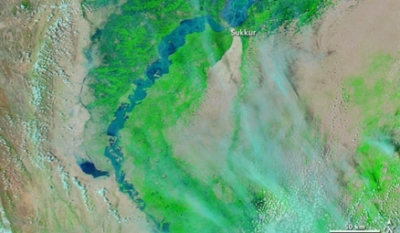
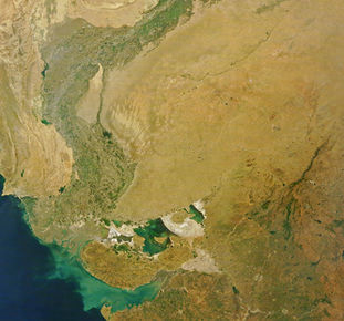
Indus River at flood stage near Sukkur from satellite. Source: NASA
The Indus River is one of the major rivers of the world that drains one of Asia's chief catchment basins, and is the locus of some of the earliest known human civilizations.
|
|
|
|

The Indus Basin measures 399.000 square kilometers, ranked as the twelfth largest river basin on Earth.
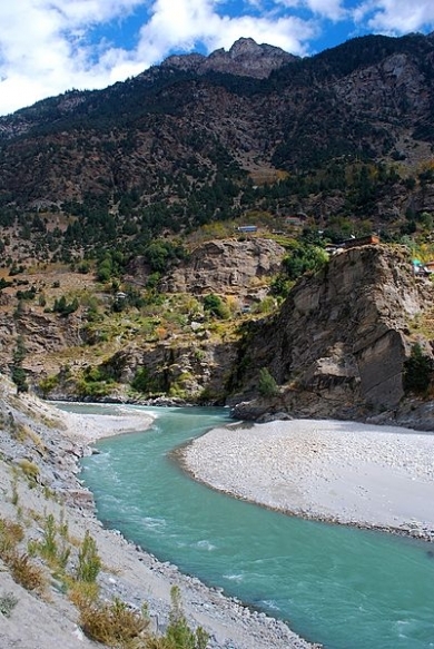
Headwaters of the river can be traced to the Tibetan Plateau, thereafter flowing through India and Pakistan to discharge to the Arabian Sea.
Flow of the perennial Indus is dominated by: (a) meltwaters from the Tibetan ice field, the third largest ice sheet formation in the world; (b) snowfall and snowmelt from higher elevation of the watershed; and (c) episodic monsoonal rains that lead to periodic flooding in the basin.
The Indus River supplies essential ingredients for human life for many urban areas including the Pakistani cities of Islamabad, Lahore, Peshawar and Karachi. This freshwater supply has been in long term decline for decades due to the human population explosion of this region and upriver withdrawals in both Pakistan and India.
In the Indus River there are a number of aquatic organisms, notably the endangered species Indus River dolphin. There are also numerous demersal fish species present in the Indus mainstem and its tributaries.
Contents
Geological history
Evidence of prehistorical flows of the Indus River is exhibited by sediment deposition in the Arabian Sea, and also to an earlier delta created by eastward flow to merge with the Ganges River at a point in time older than five million years ago. At an even earlier date of around 50 to 45 million years before present, there is evidence of a proto Indus River delta emerging into the Arabian Sea. Thus this great river has had a major change of course and direction at least twice in the most recent fifty million years.
Hydrology
Major tributaries of the Indus rise in the Himalayan Mountains and the Hindu Kush; these influent rivers include the Chenab, Jhelum, Ravi and Sutlej.
The Indus mainstem rises on the Tibetan Plateau and flows generally westward; interestingly, Asia's largest river, the Yangtze River also rises on the east side of the Tibetan Plateau and flows eastward through China.
One major tributary of the Indus rises in Afghanistan: the Kabul River.
Generally the Indus sustains slower velocities with a wider channel as the river approaches its delta on the Arabian Sea. The Indus transports massive amounts of silt generated by human disturbances in its watershed as well as the torrential monsoonal rain events.
Principal flow is carried by the western tributaries: chiefly the Chenab, Jhelum and mainstem Indus, which combine to contribute about 179 billion cubic meters of flow per annum; however, approximately 120 to 130 billion cubic meters of this flow are diverted form agricultural uses in the basin. Another roughly ten billion cubic meters are lost to evapotranspiration and floodwater loss from the channel, before the Indus waters reach the delta.
Since ancient times local peoples have established temporary dams and diversions for the purpose of agriculture and human domestic use. These holding structures, termed barrages, are sufficiently large that they are readily seen from space platforms (NASA. 2009)

Tributaries of the Indus River. Source: Creative Commons based on based on The Times Atlas of the world (Family edition)
Water quality
Water quality issues in the Indus Basin have historically been dominated by sediment loading in a watershed which is subject to high natural erosivity, and early disturbance by sedentary agriculture on the floodplains and valleys. Beginning in the twentieth century, water pollution has been aggravated by massive water withdrawals for agriculture that have then concentrated pollutants. The Green Revolution has exacerbated water pollution by considerable additions of nitrate to promote crop growth. Other aggravating factors have included increasing amounts of herbicides and pesticides, as pressures to increase crop production expand. Salinity levels in downriver areas is also a concern, as agricultural return waters and concentration of salts from water withdrawals places pressure on salinity.
Aquatic biota
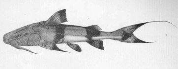 Giant devil catfish can attain a length of over 2.4 meters. @ Thomas Henry Sullivan The largest aquatic faunal species is the endangered marine mammal Indus River dolphin. There are a number of native high trophic level demersal (fish living on or near the bottom) fish species present in the Indus, including the mottled loach (Acanthocobitis botia), the 244 centimeter (cm) giant devil catfish (Bagarius yarrelli), silond catfish (Silonia silondia), the 180 cm Long-whiskered catfish (Sperata aor), the 150 cm giant river-catfish (Sperata seenghala) and the 150 cm near threatened clown knifefish (Chitala chitala), the last three of these species being very large fish, that often mature at over one meter in length; the measurements given are the species typical maximum length by each taxon in the Indus River.
Benthopelagic fish inhabit the water column niche immediately above the bottom, feeding on benthos and zooplankton. There are a number of moderate sized native benthopelagic fish taxa that are found in the Indus River system including: the 70 cm scaly osman (Diptychus maculatus), the 30 cm reba (Bangana ariza), the 30 cm Indus snowtrout (Ptychobarbus conirostris), the 30 cm Kunar snowtrout (Schizothorax labiatus), the 35 cm false osman (Schizopygopsis stoliczkai), the 47 cm Chirruh snowtrout (Schizothorax esocinus), and the 40 cm Sattar snowtrout (Schizopyge curvifrons).
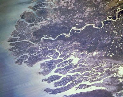 Braided channels of the Indus River delta, fringing on the Arabian Sea. @ NASA
Delta
The delta of the Indus River consists of an area of approximately 41,400 square kilometers, about one seventh of which is active as a sediment deposition zone. The climate of this area is quite arid, with typical annual precipitation averaging 250 to 500 millimeters. Correspondingly, this is one of the most arid mangrove ecosystems (Mangrove ) on Earth. The earliest recorded history of the Indus delta derives from Alexander the Great mooring the Macedonian fleet here circa 325 BC., with attendant tsunami damage to his fleet.
Since approximately 1970 the flow rate to the delta has diminished sharply, due to upriver diversions and dramatic population growth in the basin. As of 1994 the delta freshwater inflow was estimated at approximately 43,000,000,000 cubic meters, containing about 100,000,000 metric tons of silt.
Terrestrial ecosystems
|
The Idus basin includes a wide range of ecosystems between its headwaters in the Tibetan Plateau Himalayan Mountains and its delta on the Arabian Sea. 1.Indus River Delta-Arabian Sea mangroves |
|

Several of the ecoregions in the Indus watershed have their salient characteristics summarized in the following:
Central Tibetan Plateau alpine steppe
The Central Tibetan Plateau alpine steppe is the ecoregion near the headwaters of the Indus River. The Tibetan Plateau, treeless except in the southeastern river valleys, supports a gamut of alpine vegetation types that includes meadow, steppe, cold desert and sub-nival cushion plant communities at elevations ranging from 3500 to nearly 6000 meters. Dry, cold, and expansive, the Tibetan Plateau possesses an alpine landscape of complex zonation with a general trend from moist alpine scrub to steppe vegetation gradating to high, cold desert along a transect from southeast to northwest.
Dominant vegetation is a sparse steppe of purple feathergrass (Stipa purpurea), a hardy species for which this ecoregion is the center of distribution. Total plant cover seldom exceeds 20 percent. Some cushion plants and woolly alpine forbs like Leontopodium, Saussurea, Arenaria bryophylla, and Thylacospermum caespitosum also grow here and owe their distinctive morphology to the rigors of the alpine environment, including a short growing season, persistent winds, high potential evapotranspiration, and intense solar radiation (Sunlight). As the climate across the Changtang becomes colder and drier on a transect from southeast to northwest, dominant plant species change along a sequence of Kobresia pygmaea (a turf-forming sedge), Stipa purpurea, Carex moorcroftii (a sedge), and cushion forbs such as Ceratoides compacta.
Indus River Delta-Arabian Sea mangroves
 Avicennia marina, prevalent mangrove species of the Indus delta. This mangrove ecoregion occupies most of the delta of the Indus River at the discharge region to the Arabian Sea. High salinity levels are prevalent in the sloughs of the Indus River Delta-Arabian Sea mangroves because of the high evaporation rates and the salts that are washed down by the river, which flows through a highly saline area. Climatic conditions are extreme. Ambient temperatures range from near-freezing temperatures in the winter to higher than 50 degrees Celsius during the summer. All rainfall is associated with the July to September southwest monsoon, which brings a mere 100 to 500 millimeters (mm) of precipitation.
Mangroves in general are not diverse compared with most other terrestrial ecosystems, and undisturbed mangrove forests have a dense canopy with little stratification and an undergrowth made up of seedlings and saplings from the canopy trees. The Indus River mangroves are even less diverse, being comprised of nearly monospecific stands of Avicennia marina, a species that is highly resistant to high salinity levels and capable of surviving the region's extreme conditions. Other species that are sometimes associated with the Avicennia include Rhizophora apiculata and Acanthus ilicifolius, with occasional smaller patches of Rhizophora mucronata and Ceriops tagal scattered throughout. The former usually are found closer to braided creeks within the delta.
Thar Desert
 Thar Desert viewed from space. Source: NASA The Thar Desert, which lies along much of the southeastern boundary of the Indus River, displays habitat influenced by the extreme climate. The sparse [[plant]life] consists of xerophilious grasslands of Eragrostis spp. Aristida adscensionis, Cenchrus biflorus, Cympogon spp., Cyperus spp., Eleusine spp., Panicum spp., Lasiurus scindicus, Aeluropus lagopoides, and Sporobolus spp. Scrub vegetation consists of low trees such as Acacia nilotica, Prosopis cineraria, P. juliflora, Tamrix aphylla, Zizyphus mauritiana, Capparis decidua, and shrubs such as Calligonum polygonoides, Calotropis spp., Aerva spp., Crotalaria spp., and Haloxylon salicornicum. Haloxylon recurvum are also present.
In spite of the extremely hot climate, several species have evolved to survive the conditions of the Thar Desert. Among the mammalian fauna, the blackbuck (Antilope cervicapra), chinkara (Gazella bennettii), caracal (Felis caracal), and desert fox (Vulpes bengalensis) inhabit the open plains, grasslands, and saline depressions known as chappar or rann in the core area of the desert. The entire mammalian fauna consists of forty-one species, none of which are endemic to the ecoregion; however, the blackbuck is a threatened species whose populations take refuge in this harsh environment.
Among the 141 birds known in this ecoregion, the great Indian bustard (Chirotis nigricaps) is a globally threatened species whose populations in this ecoregion have rebounded in recent years. A migration flyway used by cranes (Grus grus, Anthropoides virgo) and flamingos (Phoenicopterus spp.) cross the Thar on their way to the Rann of Kutch further to the south.
Ancient history
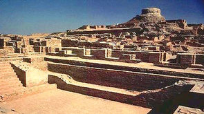 Ruins of the Bronze Age city Moheno-daro. The Indus River Valley boasts one of the earliest locales transitioning to sedentary agriculture, with evidence in the early Holocene of wheat, barley and sheep farming as early as 11,000 years ago. At Mohenjo-daro in the Indus basin circa 4600 years before present, a population of around 40,000 was present, whose works include the building of a platform under its citadel requiring an estimated 300 to 400 thousand man days of labor. These data imply vast discretionary time for humans generated by sedentary agriculture. (McIntosh.2008) Mohenjo-daro was thought to be the largest city in south Asia of its era. Total land area at Mohenjo-daro (including agricultural use) was approximately 150,000 acres, and the human population was about 40,000. Farther upriver at Harappa, another early Bronze Age culture emerged slightly later, evincing additional evidence that the Indus basin was one of the earliest world regions to establish advanced agriculture as well as urbanization.
References
- Peter D.Clift and Jerzy Blusztajn (December 15, 2005). Reorganization of the western Himalayan river system after five million years ago. Nature 438 (7070): 1001–1003
- A.H.Dani. 1992. Critical Assessment of Recent Evidence on Mohenjo-daro. Second International Symposium on Mohenjo-daro, February, 1992
- Avijit Gupta, ed. 2008. "The Geographic, Geological and Oceanographic setting of the Indus river". Large Rivers: Geomorphology and Management. John Wiley & Sons. ISBN 9780470723715.
- Kumar Jain, Pushpendra K. Agarwal, Vijay P. Singh. 2007. Hydrology and water resources of India. 1258 pages Google eBook
- M.Rajesh Kumar, A.S.Rajawat and T.N.Singh. 2005. Applications of remote sensing for educidate the Palaeochannels in an extended Thar desert, Western Rajasthan, 8th annual International conference, Map India 2005, New Delhi.
- J.M.Kenoyer. 1997. Trade and Technology of the Indus Valley: New insights from Harappa Pakistan, World Archaeology, 29(2), pp. 260-280, High definition archaeology
- J.MacKinnon. 1997. Protected areas systems review of the Indo-Malayan realm. Canterbury, UK: The Asian Bureau for Conservation (ABC) and The World Conservation Monitoring Center (WCMC)/ World Bank Publication.
- Jane McIntosh. 2008. The ancient Indus Valley: new perspectives. ABC-CLIO. 441 pages
- Monirul Qader Mirza and Qazi Kholiquzzaman Ahmad. 2005 Climate change and water resources in South Asia. 322 pages Google eBook
- Tim McNeese and Shane Mountjoy. 2004. The Indus River. books.google.com 110 pages
- National Aeronautics and Space Administration. 2009. Seasons of the Indus River. NASA Earth Observatory Program
- Plutarch of Chaeronea. 79 AD. Life of Alexander, 356-323 BC, translated by John Dryden.
- G.V.Skogerboe and D.J.Bandaragoda. Towards environmentally sustainable agriculture in the Indus Basin Irrigation System. Final report. IWMI