Heard Island and McDonald Islands
| Topics: |
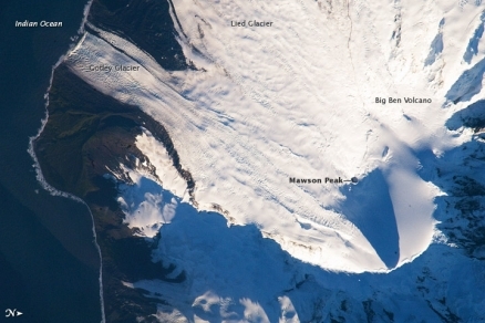
Mawson Peak on Big Ben volcano (2,745 m), Heard Island. Source: NASA
Heard Island and McDonald Islands are in the Indian Ocean, about two-thirds of the way from Madagascar to Antarctica, approximately 1,550 kilometers (963 miles) north of Antarctica. Heard Island and the McDonald Islands lie 40 km apart, the McDonald Islands to the west of Heard Island.

The largest island, Heard Island, is 80% ice-covered, bleak and mountainous, dominated by a large massif (Big Ben) and an active volcano (Mawson Peak). The McDonald Islands and small and rocky.
These uninhabited, barren, sub-Antarctic islands were transferred from the UK to Australia in 1947. It is administered from Canberra by the Department of Sustainability, Environment, Water, Population and Communities.
Populated by large numbers of seal and bird species, the islands have been designated a nature preserve.

|
|

Heard Island is a visible part of the Kerguelen Plateau, a submerged feature on the seafloor. The plateau was formed when large amounts of volcanic rock erupted over a geologically short time period. (When large amounts of volcanic rock erupt beneath the ocean from processes other than seafloor spreading, geologists refer to them as large igneous provinces.) Most of Heard Island is formed from volcanic rocks associated with the Big Ben stratovolcano. The northeastern slopes of the volcano are visible in shadow at the lower right of this detailed astronaut photograph.
Mawson Peak on Heard Island is the highest Australian mountain. At 2,745 meters, (9,006-foot), it is taller than Mt. Kosciuszko in Australia proper), and one of only two active volcanoes located in Australian territory, the other being McDonald Island.
Mawson Peak, sits within a breached caldera on the southwestern side of the Big Ben Volcano. Calderas form when a magma chamber beneath a volcano empties and collapses. The shadow cast by Mawson Peak points directly to the crescent-shaped caldera rim. Detailed geologic study of Big Ben Volcano is complicated by the presence of several glaciers, including Gotley and Lied Glaciers on the southwestern slopes.
The image above this article was taken during Southern Hemisphere summer, also reveals non-glaciated volcanic rock (light to dark brown) on either side of Gotley Glacier.
(Note: Astronaut photograph ISS018-E-38182 was acquired on February 28, 2009, and is provided by the ISS Crew Earth Observations experiment and the Image Science & Analysis Laboratory, Johnson Space Center.)
In 1992, McDonald Island broke its dormancy and began erupting; it has erupted several times since, the most recent being in 2005.
The is offshore anchorage only.
Heard Island and the McDonald Islands are a World Heritage Site.
Heard Island and the McDonald Islands are included within the Southern Indian Ocean Islands tundra ecoregion which also encompases Prince Edward, Crozet, and Kerguelen, Islands.
Location: islands in the Indian Ocean, about two-thirds of the way from Madagascar to Antarctica
Geographic Coordinates: 53 06 S, 72 31 E
Area: 412 sq km
Coastline: 101.9 km
Maritime Claims:
exclusive fishing zone: 200 n
Natural Hazards: Mawson Peak, an active volcano, is on Heard Island
Terrain: Heard Island - 80% ice-covered, bleak and mountainous, dominated by a large massif (Big Ben) and an active volcano (Mawson Peak); McDonald Islands - small and rocky. The highest point is Mawson Peak on Big Ben volcano (2,745 m).
Climate: antarctic
Natural Resources: Fish. The islands have no indigenous economic activity, but the Australian Government allows limited fishing in the surrounding waters.
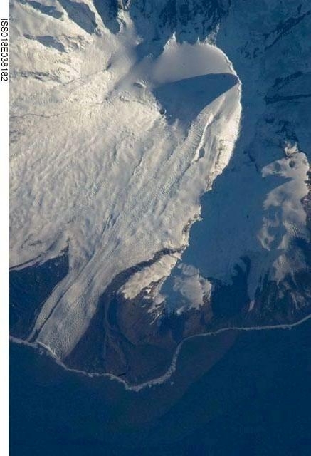
The northeastern slopes of Big Ben volcano on Heard Island are visible in shadow at the top right of this photo. Mawson Peak (small circle in the upper center of the image), sits within a breached caldera (collapsed and empty magma chamber beneath a volcano) on the southwestern side of the volcano - the shadow cast by Mawson Peak points directly to the crescent-shaped caldera rim. This image, taken during the Southern Hemisphere summer, also shows the dark brown volcanic rock that forms the island. The southwest-pointing tongue of ice is Gotley Glacier. Image credit: NASA.