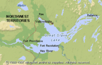
Great Slave Lake, Northwest Territories
| Topics: |
Physical Attributes
 (Source: Biodiversity Institute of Ontario)
 - Altitude: 156 m above sea level
- Surface Area: 27,200 sq. km
- Mean Depth: 41 m
- Maximum Depth: 614 m
- Volume: 1,580 cu. km
- Shoreline Length: 3057 km
- Drainage Basin: 971,000 sq. km
General Description
 (Source: Biodiversity Institute of Ontario)
 Great Slave Lake is an enormous, complex body of water. It is the fourth largest lake in Canada and was formed as a result of glacial scouring. The lake has a large, open western basin and a narrow eastern arm with many islands. Great Slave Lake is drained by the MacKenzie River and has many inflows, of which the Slave River from Lake Athabasca is the largest. Each day in the summer, the Slave River dumps 54,000 metric tons of dissolved minerals and 36,000 metric tons of silt into the southern part of the main lake basin, which has a mineral content of 160 ppm. The eastern arm and northern shore of the main basin have a lower dissolved mineral content (22-82 ppm) as a result of dilution by stream inflow off the Pre-Cambrian Shield. The large bays of the eastern arm are extremely deep (e.g. Christie Bay 614 m) and permafrost covers most of the north shore. This extremely oligotrophic lake has low standing planktonic crops, a limited benthic invertebrate community (six species), and sparse populations of fish. The short summer in this subarctic climate is reflected by the condensed two-week period of yearly growth in whitefish during August.
Watershed
Great Slave Lake receives much of its water from the Rocky Mountains via the Slave, Peace and Athabasca Rivers, as well as from the Taiga Plain.