Grassland (Agricultural & Resource Economics)
Grassland
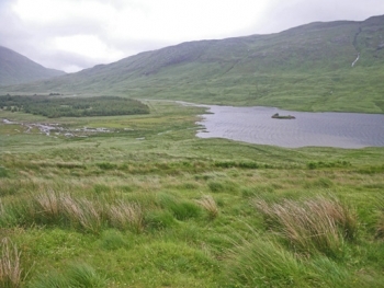
Grasslands are generally dominated by plants in the family Poaceae. While generally quite biologically diverse they can also contain members of the rush family as well as a large variety of wildflowers. Perennial grass root systems often have remarkable soil conservation properties, forming subsurface mats or sometimes having roots that extend downward by tens of metres. Typical average rainfall for grassland biomes is 500 to 1000 millimetres per annum. Grasslands are often some of the most important habitats for conservation, since they are inherently vulnerable to agricultural conversion and urbanisation. The image at the right illustrates a healthy grassland on the island of Mull, Scotland, displaying rush and sedge components as well as a gamut of forbs.
.jpg) Highveld grasslands (Grassland) Last Updated on 2015-07-07 21:46:02 WWF Terrestrial Ecoregions Collection Highveld grasslands ecoregion covers a large portion of west-central South Africa. Grasslands all over the world have experienced dramatic habitat destruction as a result of anthropogenic changes. The Highveld grasslands are no exception, with agriculture severely fragmenting this once-expansive region. This ecoregion now provides the last remaining stronghold of a number of grassland species that have suffered major reductions in abundance in the grassland biome, and which are consequently threatened with extinction (e.g. the Blue Crane (Anthropoides paradisea). There is a relatively biodiverse vertebrate fauna, with 608 taxa recorded. This ecoregion is part of the Montane Grasslands and Shrublands biome, within the Afrotropics Realm. The ecoregion draws its name from the high interior plateau known as... More »
Highveld grasslands (Grassland) Last Updated on 2015-07-07 21:46:02 WWF Terrestrial Ecoregions Collection Highveld grasslands ecoregion covers a large portion of west-central South Africa. Grasslands all over the world have experienced dramatic habitat destruction as a result of anthropogenic changes. The Highveld grasslands are no exception, with agriculture severely fragmenting this once-expansive region. This ecoregion now provides the last remaining stronghold of a number of grassland species that have suffered major reductions in abundance in the grassland biome, and which are consequently threatened with extinction (e.g. the Blue Crane (Anthropoides paradisea). There is a relatively biodiverse vertebrate fauna, with 608 taxa recorded. This ecoregion is part of the Montane Grasslands and Shrublands biome, within the Afrotropics Realm. The ecoregion draws its name from the high interior plateau known as... More » 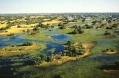 Zambezian flooded grasslands Last Updated on 2015-06-01 15:56:03 WWF Terrestrial Ecoregions Collection Located within the miombo and mopane woodlands of the Central African Plateau, Zambezian flooded grasslands are an anomaly of productivity and abundance in a landscape characterized by nutrient deficientsoil and associated vegetation. Unlike the surrounding woodlands that generally support animals only in rather low densities, the wetlands and floodplains of this ecoregion provide habitats to sizable faunal populations, since food and water are abundant throughout the majority of the year. Large populations of waterbirds gather during the rainy season, and numerous herd animals and carnivores frequent the landscape. However, in a climate of rapid population growth and increasing need for land and natural resources, this fragile ecoregion may face increasing threat. Several conservation measures... More »
  Montana valley and foothill grasslands Last Updated on 2014-06-17 00:36:34 WWF Terrestrial Ecoregions Collection The Montana valley and foothill grasslands ecoregion occupies high valleys and foothill regions in the central Rocky Mountains of Montana in the USA and Alberta, Canada. The ecoregion, part of the Nearctic realm, occupies the Rocky Mountain Front, the uppermost flatland reaches of the Missouri River drainage involving part of the Yellowstone River basin, and extends into the Clark Fork-Bitterroot drainage of the Columbia River system. The ecoregion, consisting of three chief disjunctive units, also extends marginally into a small portion of northern Wyoming. Having moderate vertebrate species richness, 321 different vertebrate taxa have been recorded in the Montana valley and foothill grasslands. The Montana valley and foothill grasslands is deemed an element of the Temperate Grasslands, Savannas, Shrublands... More »
  Palouse grasslands (Grassland) Last Updated on 2014-06-16 00:46:21 WWF Terrestrial Ecoregions Collection The Palouse grasslands ecoregion extends over eastern Washington, northwestern Idaho and northeastern Oregon. Grasslands and savannas once covered extensive areas of the inter-mountain west, from southwest Canada into western Montana in the USA. Today, areas like the great Palouse prairie of eastern are virtually eliminated as natural areas due to conversion to rangeland. The Palouse, formerly a vast expanse of native wheatgrasses (Agropyron spp), Idaho Fescue (Festuca idahoensis), and other grasses, has been plowed and converted to wheat fields or is covered by Drooping Brome (Bromus tectorum) and other alien plant species. The Palouse lies in the rain shadow of the Cascades and has a generally semiarid climate. This climate is similar to that of the annual grasslands of California, yet the Palouse... More »
 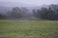 Table Mountains, California Last Updated on 2014-06-11 14:12:14 The Table Mountains of California lie at the eastern verge of the California Central Valley with the foothill slopes of the Sierra Nevada Mountains rising in successive ridges to their east. The Table Mountain Range is floristically noted as one of the few extant refugia for the once vast native grasslands of Central California. Unlike most of this original native grassland expanse, whose character was substantially altered beginning in the mid nineteenth century with waves of European settlers and gold prospectors, parts of the Table Mountain Range is substantially ecologically intact. This intact portion within the Table Mountains is often simply termed Table Mountain, designating the prominent northern mesa within Butte County; this landform element is the best known venue for the elaborate spring wildflower profusion that draws numerous visitors each year. Certain maps... More »