Fraser Island, Australia
Contents
- 1 Geographical Location
- 2 Date and History of Establishment
- 3 Area
- 4 Land Tenure
- 5 Altitude
- 6 Physical Features
- 7 Climate
- 8 Vegetation
- 9 Fauna
- 10 Cultural Heritage
- 11 Local Human Population
- 12 Visitors and Visitor Facilities
- 13 Scientific Research and Facilities
- 14 Conservation Value
- 15 Conservation Management
- 16 IUCN Management Category
- 17 Further Reading
Geographical Location
Fraser Island (24° 35'-26° 20'S, 152° 45'-153° 30'E) is a World Heritage Site that comprises the whole of Fraser Island, on the southeastern coast of Queensland. Boundaries of the region follow a line 500 metres (m) below high water mark. 24° 35'-26° 20'S, 152° 45'-153° 30'E
Date and History of Establishment
The first Aboriginal mission was established at White Cliffs in 1870. This mission was short lived, operating only until 1873. An Aboriginal Reserve was established at White Cliffs in 1897 and then moved to Bogimbah Creek in September of that year, where it continued to operate until 1904 in later years as a mission. Fraser Island (Great Sandy National Park) (74,900 hectares (ha)), was gazetted in 1971.
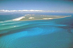
 A view of Fraser Island, Australia. (Source: Australian Government: Department of the Environment and Heritage)
 The remainder of Fraser Island consists predominantly of vacant Crown land of 78,404 hectares in public ownership, which has been proposed as a National Park extension subject to resolution of Aboriginal Land interests. Fraser Island was inscribed on the World Heritage List in 1992.
The Great Sandy Region Management Plan specifies that subject to the resolution of Aboriginal land interests, vacant Crown land on southern Fraser Island will be added to the existing national park. It is expected that any future declaration of an extended national park would be within the provisions of the Nature Conservation Act, 1992.
Area
Approximately 166,283 hectares.
Land Tenure
The state of Queensland, private tenure, and the government of Australia.
Altitude
Sea level to 240 metres.
Physical Features
The region largely reflects Quaternary geomorphological processes along a fluctuating [[coast]line], influenced by earlier geological history and the continental shelf. Fraser Island, 122 kilometres (km) long and 5-25 km wide is claimed to be the biggest sand island in the world. The sandmass is the major geological element, with the sand extending 30-60 m below present sea level. The area represents a complete sequence of sand dunes, extending from the Holocene period (less than 10,000 BP) to before the last Pleistocene interglacial period (120,000-140,000 BP). The sand derives from granites, sandstones and metamorphic rocks in river catchments to the south and from the seafloor. Fossiliferous Lower Cretaceous marine charts are exposed in the intertidal zone on the west of Fraser Island.
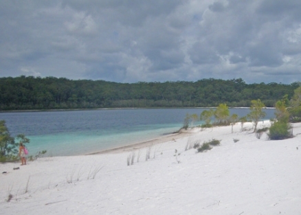
The hydrology of the sandmasses is of considerable interest and importance due to the unique strata and the almost unaltered catchments of the region. Notable features are the sandmass aquifers and the dune lakess The aquifers consist of an extensive regional freshwater 'lens' within each porous sandmass and perched aquifers associated with more or less impervious organically bound sands. Groundwater on Fraser Island is stored in massive reserves (estimated to be around 10 to 20 million megaliters (ML)) within the sandmass, of which almost six million ML is above sea level. A further 400,000 ML may be retained in the perched aquifers. Water may be stored for up to 70 to 100 years. The 40 perched, window and barrage dune lakes are unusual in the world, due to their number, size, elevation, depth and oligotrophic waters. The perched lakes on the island comprise more than half the known perched lakes in the world. Some of the perched lakes, formed in wind scoured depressions that later become impermeable due to collection of organic matter, are estimated to be up to 300,000 years old, and contain in their organic sediments a continuous record of changes to the island's hydrology and vegetation through Quaternary glacial and interglacial cycles. Window lakes form in low elevation dune depressions that intersect the Island's regional water table. Barrage lake are thought to originate from groundwater springs, dammed by a wall of landward migrating sand.
Climate
Conditions are maritime subtropical with mean annual temperatures ranging from 14.1 degrees Celsius (°C) minimum to 28.8° C maximum. Rainfall is high, reaching 1800 millimetres (mm) on the highest dunes in the center of Fraser Island.
Vegetation
Comprises seven main vegetation types: closed forest including rainforest and tall eucalypt forest dominated by satinay and brushwood; blackbutt forest; scribbly gum and wallum banksia communities; communities of wet sites often dominated by Melaleuca spp.; coastal communities; Callitris forest and woodlands; and mangrove and salt marsh. There is clear zonation and Succession of plant communities according to salinity, water table, age and nutrient status of dune sands, exposure and frequency of fires, creating a generally east-west sequence of vegetation.
The rain forest is characterized by upper strata species such as piccabeen palm Archontophoenix cunninghamiana, hoop pine, Araucaria cunninghamii, kauri pine, Agathis robusta, and carrol Backhousia myrtifolia. This community covers about 3,260 ha of the island with approximately 25% currently represented in the national park. The tall eucalypt forests, dominated by pure stands of blackbutt, Eucalyptus pilularis, occur mainly on the high dunes adjoining the rainforests. The low sclerophyll forest, behind the foredunes stretching back to the taller eucalypt forest, is dominated by scribbly gum, Eucalyptus signata.
The boundary of the region is given as 500 m below high water mark, in order to include important areas of beaches, wetlands and mangroves, and part of the extensive seagrass beds in the Great Sandy Strait, which extend to more than 12,500 ha. The region is particularly important for relict populations of fern species, with around 50 species (including varieties) found on Fraser Island. A species list is given in Twyford.
Internationally threatened species include stinking cryptocarya Cryptocarya foetida (V), Acacia baueri baueri (V), Archidendron lovelliae (V), Phaius tancervilleae (E), and Macrozamia pauli-guilielmi (E).
Fauna
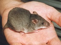
 Fraser Island is noted for the presence of the false water-rat Xeromys myoides. (Source: Environmental Protection Agency)
 The native plant communities support a significantly diverse fauna, due to the variety and specialization of a large number of habitats, although diversity within habitats is low. Few species are endemic to the sandy coastal heath area.
The island is noted for its low number and abundance of introduced species, presence of false water-rat Xeromys myoides (VU), and high genetic purity of dingo Canis lupus relative to other areas in eastern Australia. Over 300 bird species have been recorded including red goshawk Erythrotriochis radiatus (EN), black breasted button quail Turnix melanogaster(EN), beach stone curlew Esacus neglectus and ground parrot Pezoporus wallicus.
Fraser Island is rich in reptile fauna and harbors a large number of specialized sand dwelling reduced limb skinks including a possible new genus, tentatively known as the Fraser Island Skink. Populations of acid frogs such as Wallum froglet Crinia tinnula, Cooloola sedgefrog Litoria cooloolensis, Wallum rocketfrog L. freycineti and Wallum sedgefrog L.olongburensis occur, as do breeding colonies of loggerhead turtle Caretta Caretta (EN) and green turtle Chelonia mydas (EN). The island has nationally important populations of fish honey blue-eye Pseudomugil mellis (EN) and Oxleyan pygmy perch Nannoperca oxleyana (EN).
Cultural Heritage
Aboriginal people are thought to have first occupied the region about 40,000 years ago. The earliest date for the occupation of Fraser Island is currently 1,500-2,000 years, although it is possible that further archaeological work may reveal evidence of earlier occupation. Four main groups of Aborigines dominated the Great Sandy region before the arrival of Europeans. Visible remains of Aboriginal settlement include middens, canoe and gunyah trees, and a few other markings such as scars where bees nests have been removed. Although examination of the archaeological potential of the region has been restricted, a number of sites have been located, particularly adjacent to the eastern shore. Over 200 shell middens have been found on Fraser Island.
Local Human Population
Several towns, settlements and resorts, as well as camping areas, forestry camps, roads, jetties, and airstrips lie within the nominated area. Similar developments border the area to the south and west. There are additional development proposals both within and adjacent to the nominated area, several of which have already received approval.
Visitors and Visitor Facilities
Fraser Island is currently estimated to receive around 300,000 visitors a year, this number having increased rapidly since 1975. During 1993/1994, approximately 82,000 camper nights were recorded on the island.
Scientific Research and Facilities
The Great Sandy Region Scientific Advisory Committee was established in 1992 and has met periodically since this time. This committee, however, has no specific mandate for research. Previous research undertaken on Fraser Island can be identified from the bibliographies in the Commission of Inquiry reports (1990a, 1990b, 1990c) and DASETT (1991). A comprehensive bibliographic review for the island is available from the Department of Natural and Rural Systems Management, University of Queensland, Australia.
Conservation Value
Fraser Island is the largest sand island in the world. The combination of rain forests growing on tall sand dunes is believed to be a globally unique ecosystem. The array of dune lakes is exceptional in terms of number, diversity and age and the evidence they provide of dynamic development.
Conservation Management
Management of the World Heritage Area is undertaken by the Queensland Government principally through the provisions of the Nature Conservation Act 1994 and the Recreation Areas Management Act. Management is overseen by a separate Ministerial Council, comprising Federal and Queensland Government Ministers and a Management Committee consisting of the Chief Executive Officers of the Federal and State Environment Departments, the Queensland Department of Natural Resources, and the Office of National Tourism, and the Mayors of the two local authorities covering the area. Community and Scientific Advisory Committees have been established to advise the Management Committee. The Chairs of the two Advisory Committees are ex officio members of the Management Committee.
The Great Sandy Management Plan was prepared by the Queensland Government in 1994 to provide an integrated planning framework for the whole of the Great Sandy Region (of which Fraser Island is a part). Access to the island is subject to the provisions of the Recreation Areas Management Act, which provides for the collection of permit fees).
Under present legislative arrangements, Aboriginal land claims on Fraser Island may only proceed under the provisions of the Native Title Act 1993. Under the Aboriginal Land Act 1991 (Queensland), land designated as national park may be listed as claimable by the Government. Great Sandy National Park (Fraser Island Section) is not presently listed as claimable under the Act.
A network of roads and tracks exist, with approximately 1,000 km of unsealed sand tracks and 44 km of gravel roads, most of which are ungazetted and established originally for forestry purposes. There is a continuing and serious problem with the control of four-wheel-drive traffic on the island.
Management Constraints
Although there are relatively few introduced species present on Fraser Island in comparison to other mainland areas, there are extensive and widespread infestations of groundsel Baccharis halimolia and lantana Lantana camara, while species such as bitou bush Chrysanthemoides monilifera rotundata, sisal hemp Agave sisalana, and Easter cassia Senna pendula glabrata are significant localized problems. Cane toad Bufo marinus is widespread but other feral animals currently are found in low numbers. The impacts of recreational use and vehicular access are already under active management to ensure resource conservation.
The [[forest]s] of the region have been subject to logging for around 130 years. The mainland rain forests were largely cleared for timber and then agriculture, but the forests of the sand masses have fared considerably better. Many of the largest and oldest trees were removed, and the resource of scrub timber declined to unsustainable levels in some instances after less than 30 years of logging. Although there is no evidence that any species have been eliminated from the region due to logging, the forest structure, floristic composition and relative species abundance have been altered. All logging on Fraser Island had ceased by 1992, and logging has also ceased at Cooloola. The long term maintenance of the black butt forests following the cessation of forestry operations requires attention. There is evidence that in the absence of fire management theys are converting to closed forest communities.
Valuable heavy minerals occur in ore bodies throughout the sand masses of the region. To extract these, the original forest of a comparatively small (150 ha) area of land in the southeast of Fraser Island was removed, and the topography irreversibly simplified, as a result of mining which was permitted up until 1976.
There is growing concern over contamination of the freshwater lens beneath the island due to the spread of anthropogenic pathogens. Signs of eutrophication are appearing in Ocean Lake and Lake Wobby. Water quality monitoring (Environmental monitoring and assessment) is now being undertaken as part of a broader monitoring program. There has also been a major die back of seagrass beds in Hervey Beds due to flooding and siltation. Dugongs have become very scarce in area. Overfishing by commercial bottom trawlers has been indicated in the same area. Sewage and pesticide (Agricultural pesticide contamination) pollution (Water pollution) is a growing management problem in the Kingfisher Bay area.
Staff
Thirty-four staff employed by the Department of Environment and heritage presently work in Fraser Island. These staff undertake a diversity of roles including public contact, natural and cultural resource management, recreation management, infrastructure maintenance and development, enforcement, emergency response, waste removal, road management and administration. Field staff are supported by policy, planning and administrative staff located in Maryborough, Rockhampton and Brisbane.
IUCN Management Category
- II (National Park)
- Natural World Heritage Site - Criteria ii, iii
Further Reading
- DASET (1991). Nomination of Fraser Island and the Great Sandy Region by the Government of Australia for inclusion in the World Heritage List. Prepared by Department of the Arts, Sport, the Environment, Tourism and Territories. 70 pp.
- Foley, S. (1992). Aboriginal cultural heritage. Location of sites of significance to the Aboriginal community, Great Sandy Region, south-eastern Queensland. Report prepared for Queensland Department of Environment and Heritage, Maryborough.
- Free, S., Huys, S., Johnston, D. and Wickman, S. (1994). An archaeological survey of identified Badjala sites on Fraser Island. Report prepared for Thoorgine Educational and Culture Centre by Australian Archaeological Survey Consultants, Canberra.
- Hockings, M. (n.d.) Evaluating management of protected areas: integrating planning and evolution. Environmental management. In press (August 1997).
- Hockings, M. and Twyford, K.L. (1997) Assessment and management of beach camping impacts within Fraser Island World Heritage Area, Southeast Queensland. Australian Journal of Environmental Management. 4(1): 26-39.
- McNiven, I.J. (1993a). Corroboree Beach, Fraser Island: Archaeological survey and management recommendations. Queensland Department of Environment and Heritage, Maryborough (3 volumes).
- McNiven, I.J. (1993b). Corroboree Beach, Fraser Island: Archaeological survey and management plan. Queensland Department of Environment and Heritage, Maryborough.
- McNiven, I.J. (1994a). East coast, Fraser Island (Hook Point to Waddy Point): Archaeological survey and management recommendations. Queensland Department of Environment and Heritage, Maryborough (3 volumes).
- McNiven, I.J. (1994b). "Relis of a by-gone race?" Managing Aboriginal sites in the Great Sandy Region. Ngulaig Volume 12, Aboriginal and Torres Strait Islander Studies Unit, University of Queensland, St. Lucia.
- Queensland Government (1990a). Commission of Inquiry into the conservation, management and use of Fraser Island and the Great Sandy Region. Final Discussion Paper. Volume 1: Background. Queensland Government, Brisbane.
- Queensland Government (1990b). Commission of Inquiry into the conservation, management and use of Fraser Island and the Great Sandy Region. Final Discussion Paper. Volume 2: Issues. Queensland Government, Brisbane.
- Queensland Government (1990c). Commission of Inquiry into the conservation, management and use of Fraser Island and the Great Sandy Region. Final Discussion Paper. Volume 3: Issues. Queensland Government, Brisbane.
- Queensland Government (1991). Report of the Commission of Inquiry into the conservation, management and use of Fraser Island and the Great Sandy Region. Queensland Government, Brisbane.
- Queensland Government (1994). Great Sandy Region Management Plan. Fraser Implementation Unit, DEH, Brisbane.
- Sinclair, J. and Morrison, R. (1990). Fraser Island and Cooloola. Weldon Publishing, Sydney, Hong Kong, Chicago, London. 256 pp. ISBN: 0725408413.
- Twyford, K.L. (1995). Integrating Aboriginal interests into the management of Fraser Island: An appraisal of past strategies and future opportunities. Department of Tropical Environment Studies and Geography, James Cook University, Townsville.
- Twyford, K.L. (n.d.). Vascular flora of Fraser Island World Heritage Area. Central Coast Region, Department of Environment and Heritage. Unpublished report.
- Twyford, K.L. (1996). Vertebrate fauna of Fraser Island World Heritage Area. Central Coast Region, Department of Environment and Heritage. Unpublished report.
- Woodall, P.F., Pavlov, P. and Twyford, K.L. (in press). Dingoes in Queensland, Australia: skull dimensions and the identity of wild canids. Wildl. Res.
| Disclaimer: This article contains information that was originally published by the United Nations Environment Programme-World Conservation Monitoring Centre (UNEP-WCMC). Topic editors and authors for the Encyclopedia of Earth have edited its content and added new information. The use of information from the United Nations Environment Programme-World Conservation Monitoring Centre (UNEP-WCMC) should not be construed as support for or endorsement by that organization for any new information added by EoE personnel, or for any editing of the original content. |
