Environmental concerns of deepwater drilling in the Gulf of Mexico
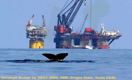
Sperm whale dives near deep-water industry platforms in Gulf of Mexico. Credit: BOEMRE
- EXCERPT FROM MMS REPORT, Deepwater Gulf of Mexico 2009: Interim Report of 2008 Highlights***
Contents
Deepwater Currents
Since 1999 the oil industry has reported significant currentsbelow the 3,000-ft (914-m) waterdepth level. This information led to a Safety Alert and subsequent studies of deep currents by the Minerals Management Service (MMS).
Concentrating on currents near the Sigsbee Escarpment, Louisiana State University deployed four full-water column moorings in the GOMin February 2000 and removed the last mooring in June 2004. These moorings were designed to measure current, along with temperature, salinity, and pressure at various depths throughout the water column. The first two moorings, Deployments 1 and 2, were located on top of the Sigsbee Escarpment in approximately 2,200 m (7,218 ft) of water. These two mooring were combined to form a single time series. The last two moorings, Deployments 3 and 4, were positioned at the base of the Sigsbee Escarpment in approximately 3,000 m (9,843 ft) of water. Strongest surface currents occurred when the Loop Current or Loop Current eddies (both anticyclonic and cyclonic) flowed near or over the mooring. Of the 24 events investigated in detail, four of the events showed surface to bottom coherence in flow, which corresponded with the intensification of a Loop Current frontal eddy cyclone in close proximity to the mooring. Relatively strong bottom currents to the northeast occurred when a large warm-core anticyclonic Loop Current eddy (ring) passed south of the mooring.
In May 2008, MMS announced the availability of a new study report, Deepwater Currents in the Eastern Gulf of Mexico: Observations at 25.5°N and 87°W. This report presents the analysis of current data collected at 87°W., 25.5°N. in water depths of approximately 3,600 m (11,811 ft), within a narrow channel connecting the eastern and central basins of the GOM. The mooring is an entire water-column array over a nearly flat bottom. The data suggest that the GOM can be viewed as a two-layer systemwith the interface at 700-800 m (2,297-2,625 ft) driven by the Loop Current and coinciding with the sill of the Florida Straits. The lower layer tends to have uniform currents in the vertical and speeds of 10-30 centimeters per second (0.3-1 feet per second). Short events of near uniform currentsfrom top to bottom were observed and coincided with a Loop Current extended to its maximum northward position shortly before shedding an eddy.
Focusing on the northwestern GOM, another study used 13 moored arrays, in water depths ranging from 500 to 3,200 m (1,640 to 10,499 ft) to document upper- and lower-layer current, temperature, and salinity fields in the area west of 93° W. longitude, north of the Exclusive Economic Zone, and south and east of the 200-m isobath. Moored data collection began in March 2004 and ended in June 2005. For the entire field measurement interval, satellite remote-sensing observations (altimetry, sea-surface temperature, and ocean color) were used to provide a context for the upper-layer field measurements and to characterize the associated circulationprocesses and patterns. The objectives of this study were (1) to collect current data to increase our deepwater database and knowledge of the deep circulation in the northwestern GOM; (2) to gather information to estimate oceanographic parameters needed to make experimental designs of full-scale, physical oceanography studies in deep water; and (3) to provide information to use in oilspill analyses, including the emerging deep spill analysis and other ongoing studies, to help evaluate exploration plans and to contribute to the preparation of NEPA documents.
The MMS awarded a $5.5 million contract to Science Applications International Corporation (SAIC) to conduct a 5-year study of the GOM Loop Current in the Eastern GOM. Nine moorings, or anchored lines, will be placed in Gulf waters for approximately 30 months. The instruments attached to the moorings will measure current strength, water temperature, and salinity levels. Scientists from the Atlantic Oceanographic and Meteorological Lab will join SAIC to study the thermal structure of the Loop Current and hope to use this data to more accurately forecast the intensification of hurricanesentering the GOM. In addition, scientists from Princeton University, the University of Rhode Island and the University of Colorado are part of the SAIC team to carry out the state-of-the-art modeling, deep ocean circulation field observations, and the remote-sensing observations for this study.
Sperm Whale Seismic Study
The MMS released the results of a 6-year, $9.3 million study on sperm whales, an endangered species living in the northern GOM. The report, Sperm Whale Seismic Study in the Gulf of Mexico: Synthesis Report, presents results from the Sperm Whale Seismic Study (SWSS) and gives recommendations for future study. The SWSS focused on the effects of seismic activities on sperm whales living in an area that is highly industrialized with oil and gas exploration and production activities. One finding supported by SWSS data is that northern GOMsperm whales are a distinct stock; that is, they show genetic differences from other 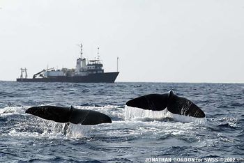 Two sperm whales "fluke-up" near the Texas A&M Research Vessel Gyre. Credit: BOEMRE sperm whales world-wide. Also, based on tag location data, the Gulf sperm whales showed no discernible seasonal migration. The study also did not find any horizontal avoidance of seismic sounds, meaning the whales did not alter their visible behavior on the surface when exposed to seismic sounds. Fifteen Federal and State agencies, universities, and organizations collaborated to meet the study’s objectives: (1) establish baseline information about the whales’ biology and behavior; (2) characterize the whales’ habitat and how the whales use their habitat; and (3) determine possible changes in the whales’ behavior when they experience human-made noise. Data gathered during SWSS provide insights into daily and seasonal movements, abundance, group structure, diving and other behaviors, habitat characteristics, and response to human-made noise of sperm whales in the northern GOM. This information will help MMS evaluate whether whales prefer some locations, what effects human activities (such as seismic surveys) may have on the whales and possible mitigation measures.
Chemosynthetic Communities
The study report, Investigations of Chemosynthetic Communities on the Lower Continental Slope of the Gulf of Mexico: Interim Report, represents the first report for a large multidisciplinary study to investigate chemosynthetic communities and deepwater, hard-bottom communities, including deepwater corals, below a depth of 1,000 m (3,281 ft) in the northern GOM. This project is a collaboration between MMS and the National Oceanic and Atmospheric Administration’s (NOAA) Office of Ocean Exploration and Research sponsored by the National Oceanographic Partnership Program. The report compiles detailed information regarding operational procedures, stations occupied, sampling activity, and preliminary results. The information in this report is a compilation of two cruises. A 2-week reconnaissance cruise was conducted from the vessel R/V Gyre from March 11-25, 2006, including drift camera work and trawling and box core sampling. A subsequent cruise was conducted on the Wood’s Hole Oceanographic Institute research vessel R/V Atlantis and the submersible Alvin from May 7 through June 2, 2006. Results reported were obtained by analysis of the sampling information and data during these cruises and immediately afterward. New chemosynthetic communities and deepwater coral communities were discovered at numerous sites. In February 2007, several study sites were mapped in great detail using the C&C Technologies Autonomous Underwater Vehicle in preparation for intensive sampling during the 2007 field season.
Deepwater Coral
450px A close-up of the scleractinian coral Lophelia pertusa from the Mississippi Canyon 751 site at approximately 450 m depth. This image was taken with the SeaEye Falcon DR ROV during the first cruise of this program in September 2008. Image courtesy of Lophelia II 2009: Deepwater Coral Expedition: Reefs, Rigs, and Wrecks. Credit: NOAA The study report, Lophelia Reef Megafaunal Community Structure, Biotopes,Genetics, Microbial Ecology, and Geology (2004-2006), represents results from a multidisciplinary project conducted by the USGS supporting the needs of MMS. Subject areas in the USGS report include demersal fish associated with Lophelia coral biotopes, deep-sea [[coral] ]biodiversity and molecular assessment, expressed genes in Lophelia, microbial ecology of Lophelia, deepwater antipatharian sclerochronology, and hard structure geological analysis of Lophelia substrate. Field sampling cruises were performed at a total of up to five locations in the northern GOMutilizing Harbor Branch Foundation vessels and one of the Johnson Sea Link submersibles in 2004 and 2005. The R/V Tommy Munro was used for an additional sampling cruise in 2005. Both samples and scientists were exchanged between the collaborating projects by CSA/MMS and USGS. Results include the first quantitative analysis of fishes associated with Lophelia reefs in the GOM, patterns of Lophelia genetic differentiation across 290 km (180 mi) of the northern GOM, discovery of new expressed genes in Lophelia, significant differences of bacterial molecular analysis between Lophelia sites and unexpected variations in substrate mineralogy between Lophelia sites. Results of this study will be utilized to develop additional studies of hard-bottom habitats in the deep GOM and will also enhance the ability of MMS to protect sensitive deepwater biological features.
On November 24, 2008, MMS announced a $3.7 million, 4-year study of deepwater corals in the GOM. The study contract focuses on deepwater coral communities that have formed both naturally and on oil and gas platforms and shipwrecks. The first round of the project, primarily dedicated to the exploration of shipwreck sites, took the researchers to a remarkable discovery of a copper-clad sailing schooner likely dating to the early 1800’s. Another wreck site visited, confirmed to be the Gulfoil, a tanker sunk by a German U-boat in 1942, was covered with dense thickets of the deepwater coral Lophelia. The study marks the first time coral community areas below 1,000 ft (305 m) will be investigated using remotely-operated vehicles. Study results will be used by MMS to create or modify existing regulatory policies and will help MMS protect these important habitats from the potential impacts of oil and gas exploration. The study includes 3 years of field work using research vessels and underwater vehicles provided by NOAA’s Office of Ocean Exploration and Research. During the second round of field work, dedicated to exploration and sampling of both known deepwater coral habitats and new unknown hard-bottom sites, scientists are collecting numerous samples of vibrant corals for analysis. Deepwater corals in the GOM have only recently been studied, and there is little information about how coral communities are distributed and how rare they may be. This study is designed to address that shortfall.
Deepwater Shipwreck
The study report, Viosca Knoll Wreck: Discovery and Investigation of an Early Nineteenth-Century Wooden Sailing Vessel in 2,000 Feet of Water, details the visual study of a wooden-hulled shipwreck discovered near the Petronius oil platform in the GOM. The study was performed by analyzing hours of video acquired using a remotely-operated vehicle. The identity and nationality of the vessel remains unknown, but the researchers concluded from the visual analysis of the hull remains that the ship was most likely a two-masted brig, brigantine, or schooner dating from the first quarter of the nineteenth century. The hull of the vessel is sheathed in copper or a cupreous alloy, which accounts for the wreck’s state of preservation. In addition to the hull, substantial remains of the standing rigging survive, lying along the starboard side. Few artifacts could be identified from the video alone, but one significant find included the discovery of a rare ship’s stove. The bow of the wreck is partly intact, but the stern is disarticulated. The site was found to have been impacted within the last decade, most likely by a large anchor cable, which is suggested by a ragged tear through the port side of the hull and a drag scar that crosses the wreck.
Subsea Processing in Deepwater Environments
The MMS study report, Effects of Subsea Processing on Deepwater Environments in the Gulf of Mexico, represents the compilation and synthesis of existing published and unpublished literature on the environmental effects of subsea operations on the deepwater environment. Subsea processing technologies that are currently being implemented in deep water include multiphase pumps (Type 1) and partial separation with pumping (Type 2). Technologies being developed for future application include combinations of separators, scrubbers, and pumps that allow complete separation of production stream at the seabed (Type 3). The most advanced systems (Type 4) are likely to include multistage separation and fluid treatment with the production of export quality oil and gas. The primary difference between surface and subsea technologies is the restricted ability to detect and respond to releases in the deepwater environment and the extreme temperatures and pressures on the seafloor. A key technological and
environmental issue involved in the implementation of subsea separation is the handling and disposal of produced waters and sands. Options include transport to the surface, reinjection into depleted formations, or discharge to the ambient environment. The potential impacts and major environmental concerns associated with subsea operations are similar to those observed with existing technologies. These include the release of drilling fluids and untreated drill cuttings during exploration and production; the catastrophic release of large volumes of hydrocarbons or utility fluids due to failures in piping, seals, andconnections; and the release of untreated produced water and sands. The difference between existing and subsea technologies is the restricted ability to detect and respond to these releases in the deepwater environment. The advent of subsea technologies also introduces new environmental issues. These include the existence of large temperature differences between operating equipment and ambient conditions, the use of new treatment chemicals, the creation of electromagnetic fields associated with the operation of pumps and other equipment on the seafloor, and noise. The potential toxic effects of new or significantly modified products for treating the production and processing flow streams on benthic and free-swimming organisms should be determined. The deeper water habitats also exhibit unique features that should be considered in regulating subsea processing. For example, the presence of methane hydrates in the seafloor sediments should be identified in advance of subsea development activities. New protocols for assessing the existence, distribution, and ecological significance of benthic communities in these habitats are required.