Water profile of Egypt
Contents
- 1 Geography, Climate and Population
- 2 Economy, Agriculture, and Food Security
- 3 Water Resources and Use
- 4 Irrigation and Drainage Development
- 5 Water management, Policies, and Legislation Related to Water Use in Agriculture
- 6 Environment and Health
- 7 Perspectives for Agricultural Water Management
- 8 Further Reading
Geography, Climate and Population
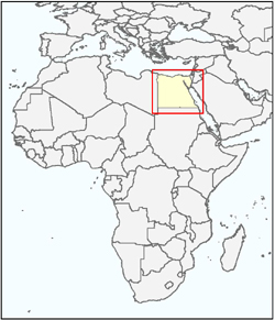 Map of Egypt. (Source: FAO-Forestry)
 Egypt lies in the northeastern corner of the African continent and has a total area of about 1 million square kilometers (km2). It is bordered in the north by the Mediterranean Sea, in the east by the Gaza Strip, Israel, and the Red Sea, in the south by Sudan and in the west by the Libyan Arab Jamahiriya. Its north-south extent is about 1 080 kilometers (km), and its maximum east-west extent about 1 100 km. The Egyptian terrain consists of a vast desert plateau interrupted by the Nile Valley and Delta which occupy about 4 percent of the total country area. The land surface rises on both sides of the valley reaching about 1,000 meters (m) above sea level in the east and about 800 m above sea level in the west. The highest point of the country, at Mount Catherine in Sinai, is 2 629 m above sea level and the lowest point, at the Qattara Depression in the northwest, is 133 m below mean sea level.
The majority of the country area is desert land. Most of the cultivated land is located close to the banks of the Nile River, its main branches and canals, and in the Nile Delta. Rangeland is restricted to a narrow strip, only a few kilometers wide, along the Mediterranean coast and its bearing capacity is quite low. There is no forest land. The total cultivated area (arable land plus permanent crops) is 3.4 million hectares (ha) (2002), or about 3% of the total area of the country. Arable land is about 2.9 million ha, or 85% of the total cultivated area, and permanent crops occupy the remaining 0.5 million ha (Table 1).
Hot dry summers and mild winters characterize Egypt’s climate. Rainfall is very low, irregular and unpredictable. Annual rainfall ranges between a maximum of about 200 mm in the northern [[coast]al] region to a minimum of nearly zero in the south, with an annual average of 51 mm. Summer temperatures are extremely high, reaching 38°C to 43°C with extremes of 49°C in the southern and western deserts. The northern areas on the Mediterranean coast are much cooler, with 32°C as a maximum.
Population is estimated at 73.4 million (2004) with an average annual growth rate of 1.8%. The rural population is 58% of the total population. Overall population density is 73 inhabitants/km2; however, with about 97% of all people living in the Nile Valley and Delta, population density reaches more than 1,165 inhabitants/km2 in these areas, while in the desert it drops to only 1.2 inhabitants/km2.
In 1997 it was estimated that 26.5% of the Egyptian population was living in poverty. The percentage was higher in rural than in urban areas and the incidence of poverty and "ultra poverty" was highest in Upper Egypt, while a larger absolute number of poor households was found in Lower Egypt because of the concentration of population there. In rural areas, about 29% of the population was living in poverty, compared to 23% of the urban inhabitants. Inadequate social services, landlessness, small farm size and inadequate off-farm income opportunities are the main causes of rural poverty.
In 2000, about 96% of the rural population and 99% of the urban population had access to improved drinking water sources, with an average of 97% of the total population. Almost 100% of the urban population and 96% of the rural population had access to improved sanitation, with an average of 98% of the total population.
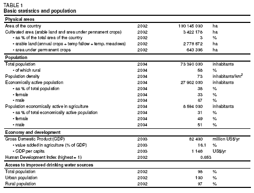 Table 1: Basic statistics and population. (Source: FAO-Forestry)
 Economy, Agriculture, and Food Security
In 2003, Egypt’s Gross Domestic Product (GDP) was estimated at US$82.4 billion with an annual growth rate of 3.2%. The agricultural sector accounted for 16.81% of GDP and employed about 31% of the labor force, of which 49% were female (Table 1).
Egypt is self-sufficient in almost all agricultural commodities with the exception of cereals, oils, and sugar; however, these exceptions make Egypt one of the world’s largest food importers. Agricultural imports in 2001 included 4.4 million tons of wheat and wheat flour, 4.7 million tons of yellow maize, 0.6 million tons of vegetable oils, and 0.4 million tons of sugar. On the other hand, the main export crops were, amongst others, 53,000 tons of cotton, 444,000 tons of rice, 176,000 tons of potatoes, and 37,000 tons of citrus.
In Egypt, 99.8% of cropland was irrigated in 1997. Even the small, more humid area along the Mediterranean coast requires supplementary irrigation to produce reasonable yields. Smallholdings characterize Egyptian agriculture; about 50% of holdings have an area less than 0.4 ha (1 feddan). Farmland urbanization represents a serious threat to agriculture in Egypt. It is prohibited by law to construct any buildings on farmland without a license from the Ministry of Agriculture and Land Reclamation, and violators are prosecuted and face serious penalties.
Water Resources and Use
Water Resources
The Egyptian territory comprises the following river basins:
- The Northern Interior Basin, covering 520,881 km2 or 52% of the total area of the country in the east and southeast of the country. A sub-basin of the Northern Interior Basin is the Qattara Depression.
- The Nile Basin, covering 326,751 km2 (33%) in the central part of the country in the form of a broad north-south strip.
- The Mediterranean Coast Basin, covering 65,568 km2 (6%).
- The Northeast Coast Basin, a narrow strip of 88,250 km2 along the coast of the Red Sea (8%).
The River Nile is the main source of water for Egypt, with an annual allocated flow of 55.5 cubic kilometers per year (km3/yr) under the Nile Waters Agreement of 1959. Internal surface water resources are estimated at 0.5 km3/yr. This brings total actual surface water resources to 56 km3/year. The Nubian Sandstone aquifer located under the Western Desert is considered an important groundwater source. The volume of groundwater entering the country from the Libyan Arab Jamahiriya is estimated at 1 km3/yr. Internal renewable groundwater resources are estimated at 1.3 km3/yr, bringing total renewable groundwater resources to 2.3 km3/yr. The main source of internal recharge is percolation from irrigation water in the Valley and the Delta. The total actual renewable water resources of the country is thus 58.3 km3/yr (Table 2).
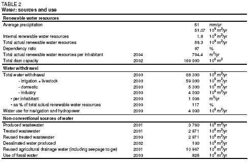 Table 2: Water: sources and use. (Source: FAO-Forestry)
 All drainage water in Upper Egypt, south of Cairo, flows back into the Nile and the irrigation canals; this amount is estimated at 4 km3/yr. Drainage water in the Nile Delta is estimated at 14 km3/yr. Treated domestic wastewater in 2001/02 was estimated at 2.97 km3/yr. There are several desalination plants on the [[coast]s] of the Red Sea and the Mediterranean to provide water for seaside resorts and hotels; total production in 2002 was estimated at 100 million m3. Estimates of the potential of non-renewable groundwater in the eastern and western deserts, mainly from the Nubian Sandstone aquifer, vary from 3.8 km3/yr to 0.6 km3/yr; the latter estimate is defined as an indicator of exploitability over a period of time, where the time is not given.
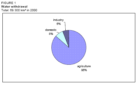 Figure 1: Water withdrawal. (Source: FAO-Forestry)
 Water Use
Total water withdrawal in 2000 was estimated at 68.3 cubic kilometers (km3). This included 59 km3 for agriculture (86 percent), 5.3 km3 for domestic use (8 percent) and 4.0 km3 for industry (6 percent) (Table 2 and Figure 1). Apart from that, 4.0 km3 were used for navigation and hydropower (Table 3).
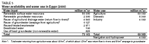 Table 3: Water availability and water use in Egypt (2000). (Source: FAO-Forestry)
 Groundwater extraction in 2000 was 7.043 km3 comprising:
- 6.127 km3 from the Nile Basin (seepage waters)
- 0.825 km3 from the eastern and western deserts, i.e. mainly the Nubian Sandstone aquifer
- 0.091 km3 from shallow wells in Sinai and on the northwestern coast
Reuse of agricultural drainage water, returned to the rivers, in irrigation amounted to 4.84 km3/yr in 2001/02. Of the 2.97 km3/yr of treated wastewater, 1.5 km3/yr is reused for irrigation, while the rest is pumped into main drains where it mixes with drainage water and is then used for irrigation. Treated wastewater is usually used for landscape irrigation of trees in urban areas and along roads.
International Water Issues
Under the 1959 Nile Waters Agreement between Egypt and Sudan, Egypt’s share of the Nile flow is 55.5 km3/yr. The agreement was based on the average flow of the Nile during the 1900-1959 period, which was 84 km3/yr at Aswan. Average annual evaporation and other losses from the Aswan High Dam and reservoir (Lake Nasser) were estimated at 10 km3/yr, leaving a net usable flow of 74 km3/yr, of which 18.5 km3/yr was allocated to Sudan and 55.5 km3/yr to Egypt.
In 1998, recognizing that cooperative development was the best way to bring mutual benefits to the region, all riparian countries (except Eritrea which had observer status only) joined in a dialogue to create a regional partnership to facilitate the common pursuit of sustainable development and management of Nile waters. The transitional mechanism, the Nile Basin Initiative (NBI), was officially launched in February 1999 in Dar es Salaam, the United Republic of Tanzania, by the Council of Ministers of Water Affairs of the Nile Basin States. The shared vision of the NBI is "to achieve sustainable socio-economic development through the equitable utilization of and benefit from the common Nile Basin water resources".
The first meeting of the International Consortium for Cooperation on the Nile (ICCON) took place in 2001 in Geneva, Switzerland to celebrate cooperation between the ten countries of the Nile Basin and to establish partnerships leading to sustainable development and management of the Nile River for the benefit of all. The ICCON’s first meeting was a major milestone for the NBI as it brought together, for the first time, ministers, and senior officials from Nile Basin countries with a broad range of bilateral and multilateral donors and other interested parties from civil society, professional organizations, the media, and NGOs.
If conditions permit the completion of the development projects on the Upper Nile, Egypt’s share in the Nile water will increase by 9 km3. This amount includes 1.9 km3 and 1.6 km3 respectively from the first and second phases of the Jonglei canal project in southern Sudan. Two other projects in the upstream swamps are expected to provide 5.5 km3.
The vast Nubian Sandstone aquifer is shared with the Libyan Arab Jamahiriya, Sudan, and Chad.
Irrigation and Drainage Development
Evolution of Irrigation Development
Irrigation potential is estimated at 4,420,000 ha. The total area equipped for irrigation was 3,422,178 ha in 2002; 85% of this area is in the Nile Valley and Delta. Rainwater harvesting is practiced in about 133,500 ha in Matruh and North Sinai. All irrigation is full or partial control irrigation (Table 4). Surface irrigation was practiced on 3,028,853 ha in 2000, while 171,910 ha were under sprinkler irrigation and 221,415 ha under localized irrigation (Figure 2). Surface water was the source for 83% of the irrigated area in 2000, while 11% (361,176 ha) of the area was irrigated with groundwater in the provinces of Matruh, Sinai, and New Valley. The remaining 6% (217,527 ha) was irrigated with mixed sources (Figure 3). The power irrigated area in 2000 was estimated at 2,937,939 ha.
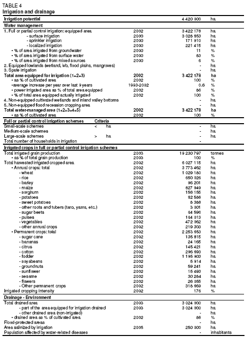 Table 4: Irrigation and drainage. (Source: FAO-Forestry)
 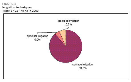 Figure 2: Irrigation techniques. (Source: FAO-Forestry)
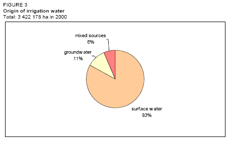 Figure 3: Origin of irrigation water. (Source: FAO-Forestry)
 The irrigation system in the old land of the Nile Valley is a combined gravity and water lifting system. Downstream of the High Aswan Dam, there are seven barrages (i.e., artificial obstructions in a watercourse to promote irrigation) to facilitate abstraction. The main canal system (first level) comprises 31,200 km of canals and takes its water from head regulators, located upstream of the Nile barrages. Water is distributed along branches (second level) where the flow is continuous. At the third level, distributaries receive water according to a rotation schedule. Water is pumped from the distributaries to irrigate fields (lift: about 0.5-1.5 m). The irrigation system in the new lands (reclaimed areas) is based on a cascade of pumping stations from the main canals to the fields, with a total lift of up to 50 m. Surface irrigation is banned by law in the new reclaimed areas, which are located at the end of the systems, and are more at risk of water shortage. Farmers have to use sprinkler or drip irrigation, which are more suitable for the mostly sandy soil of those areas. If used efficiently, sprinkler and drip irrigation need less water than surface irrigation.
In addition to the older developments in the oasis of the New Valley, which pump water from the Nubian Sandstone aquifer, new large irrigation schemes are under development in the southwestern part of the country at Al Oweinat; in 2003 about 4,200 ha were under cultivation and there are plans to extend the project to several times that area.
In the Fayoum Province, irrigation was practiced with gravity until recently, without any water lifting system. By the year 2000, however, gravity irrigation was practiced on only 1,900 ha, or less than 1.2% of the cultivated area in Fayoum. Drainage water in the province is directed by gravity into Wadi Rayan and the Qaroon Lake.
Water harvesting (Matruh and Northern Sinai) is possible thanks to the construction of cisterns and diversion dikes. The average rainfall in the areas is between 220 and 250 mm.
Role of Irrigation in Agricultural Production, the Economy, and Society
The cropped area was slightly more than 6 million ha in 2002, with an average cropping intensity of 176%. There are three growing seasons in Egypt: winter - from November to May; summer - from April/May to October; and "Nili" - from July/August to October.
Most crops are grown both in the Delta and the Valley, with the exception of rice (Delta mainly) and sugarcane (Valley). The main winter crops are wheat and clover or berseem (Trifolium alexandrinum). Berseem is grown either over 3 months with 2 cuts as a soil improver (short berseem), usually preceding cotton, or over 6-7 months, either with 4-5 cuts as a fodder crop or grazed by tethered cattle (long berseem). Minor winter crops are, amongst others, pulses, barley and sugar beet. The main summer crops are maize, rice, and cotton, the latter being the most important Egyptian export crop (Table 4 and Figure 4). In 2002, yields were 6.4 tons per hectare (t/ha) for wheat, 8.1 t/ha for maize, 9.4 t/ha for rice and 2.6 t/ha for cotton.
The average cost of irrigation development is about US$800/ha for localized irrigation of orchards and about US$1,200/ha for localized irrigation of vegetable or field crops. Mobile sprinkler irrigation costs about US$800/ha and stationary sprinkler irrigation costs about US$1,800/ha.
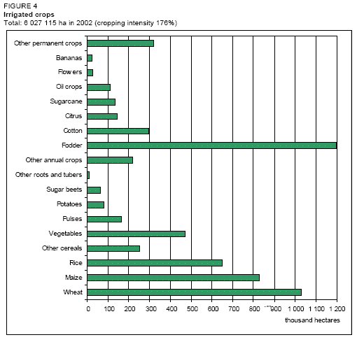 Figure 4: Irrigated crops. (Source: FAO-Forestry)
Status and Evolution of Drainage Systems
An extensive National Drainage Program has been carried out over the last four decades to control waterlogging and salinity. The drainage system consists of open drains, sub-surface drains, and pumping stations. In 2003, slightly over 3 million ha of the total irrigated area were drained, of which about 2.2 million ha with sub-surface drainage. The sub-surface drained area represents more than 65% of the total cultivated area. There are 99 pump stations devoted to the pumping of drainage effluent. The power-drained area was estimated at about 1.65 million ha in 2000. Drainage water from agricultural areas on both sides of the Nile Valley is returned to the River Nile or main irrigation canals in Upper Egypt and in the southern Delta. Drainage water in the Delta is either pumped back into irrigation canals for reuse or pumped into the northern lakes or the Mediterranean Sea.
Water management, Policies, and Legislation Related to Water Use in Agriculture
Institutions
The Ministry of Water Resources and Irrigation (MWRI) is in charge of water resources research, development and distribution, and undertakes the construction, operation, and maintenance of the irrigation and drainage networks. Specifications and permits for groundwater well drilling are also the responsibility of MWRI. Within MWRI, the following sectors and departments are of importance:
- The Planning Sector is responsible at central level for data collection, processing, and analysis for planning and monitoring investment projects.
- The Sector of Public Works and Water Resources coordinates water resources development works.
- The Nile Water Sector is in charge of cooperation with Sudan and other nilotic countries.
- The Irrigation Department provides technical guidance and monitoring of irrigation development, including dams.
- The Mechanical and Electrical Department is in charge of the construction and maintenance of pumping stations for irrigation and drainage.
Further to the above institutions, other public authorities are directly related to MWRI:
- The High Dam Authority is responsible for dam operation.
- The Drainage Authority is responsible for the construction and maintenance of tile and open drains.
- The National Water Research Center comprises 12 institutes and is the scientific body of MWRI for all aspects related to water resources management.
MWRI also represents Egypt in the meetings of the Nile basin countries on Nile water issues. There are several joint projects between those countries for the development of Nile water. These projects, if completed, would increase the water shares of member countries significantly. Egypt would gain an additional 9 km3 of Nile water.
The Ministry of Agriculture and Land Reclamation (MALR) is in charge of agricultural research and extension, land reclamation and agricultural, fisheries, and animal wealth development. The Agricultural Research Center comprises 16 institutes and 11 central laboratories and is the scientific body of MALR for all aspects related to agricultural development. The Land Development Authority is in charge of contracting and monitoring land development projects and manages land allocation to investors and individuals. The Agricultural Development and Credit Bank provides credit to farmers to finance various production requirements.
Water Management
The Government has indicated its intent to shift emphasis from its role as the central (or sole) actor in developing and managing water supply systems, towards promoting participatory approaches in which water users will play an active role in the management of irrigation systems and cost sharing. Important institutional and legislative measures have been taken recently to promote the establishment of sustainable participatory irrigation management (PIM) associations. However, despite these measures, the development of water users’ associations (WUAs) as effective partners in irrigation management remains at an early stage. In the new lands, the concept of PIM is not yet effectively operational for a variety of economic, financial, and institutional reasons.
While most settlers recognize the importance of WUAs in the equitable distribution of available water, uneven water availability, either due to design shortcomings or to lax enforcement of rules against excess abstraction by front-end water users, has acted as a disincentive to the successful operation of WUAs in many instances.
Finances
The government invests considerable resources in the land-reclamation program. Investment is primarily in irrigation and drainage infrastructure, settlement construction, and provision of potable water, electricity and roads. Very little is invested in social services (education and health), and no investment is made in the provision of agricultural services (technology, water management, and rural finance). Consequently, poor settlers face difficulties in settling and farming, and a considerable percentage move back to the old lands and abandon their new land farms.
Both MWRI and MALR activities are considered public services and their water and land development projects are budgeted in the national economic and social development plan.
Policies and Legislation
The main water and irrigation strategy is concerned with the development and conservation of water resources. This is done through adopting water rotation for irrigation canals, limiting the rice growing area, lining irrigation canals in sandy areas and prohibiting surface irrigation in the new developed areas outside the Nile basin.
Recent water resources policies include different structural and several non-structural measures. Structural measures include: irrigation structures rehabilitation; improvement of the irrigation system; installation of water level monitoring devices linked to the telemetry system; and expansion of the tile drainage system. Non-structural measures include: expansion of water user associations (WUAs) for irrigation ditches, establishment of water boards on branch canals, promotion of public awareness programs, and involvement of stakeholders.
The legal basis for irrigation and drainage is set in Law No. 12/1984 and its supplementary Law No. 213/1994 which define the use and management of public and private sector irrigation and drainage systems including main canals, feeders, and drains. The laws also provide legal directions for the operation and maintenance of public and private waterways and specify arrangements for cost recovery in irrigation and drainage networks.
The most recent water policy was drafted in 1993. It included several strategies to ensure satisfying the demands of all water users and expanding the existing agricultural area at that time of 7.8 million feddan (about 3.12 million ha) by an additional 1.4 million feddan (about 560,000 ha).
Environment and Health
Salinity and waterlogging are now under control in about 80% of the affected areas following the installation of drainage systems. This has led to a reduction in saline areas from about 1.2 million ha in 1972 to 250,000 ha at present. Seawater intrusion is a problem in the northern part of the Delta, where groundwater becomes brackish to saline. About half of the Delta contains brackish to saline groundwater, and no water is pumped in the northern Delta. Average salinity of groundwater in the Delta was between 680 and 1,170 milligrams per liter (mg/liter) in 2000/2001. It is said that the rice belt is a major defense factor to keep salinity under control in the northern areas of the Nile Delta, as well as to stop the invasion of sea water further inland in the Delta aquifer.
The salinity of agricultural drainage water is higher in winter, especially downstream because less water is used for irrigation. In the new Al Salam Canal, drainage water is mixed with Nile water at a ratio of 1:1, and the salinity of the mixed water is within safe levels.
The main challenge for the sustainability of water resources is the control of water pollution. The Ministry of the Environment is observing the enforcement of the new legislation regarding the treatment of industrial and domestic wastewater. MALR is also advocating organic farming and limiting the use of chemical fertilizers and pesticides to reduce crop, soil and water pollution. In addition, present policy is to minimize the use of herbicides and to depend mainly on the mechanized control of submerged weeds and water hyacinths.
Bilharzia, or Schistosomiasis, is still a common disease in rural areas in Egypt but its occurrence has greatly decreased with the provision of improved drinking water to most rural areas, periodic examination of school children, free medical treatment and extension programs to educate people on ways of protecting against the disease. The Ministry of Health and Population announced that Bilharzia cases in the examined samples of rural population in 2001 were only about 4%. Malaria is rare in Egypt.
Perspectives for Agricultural Water Management
In 1984 it was estimated that there were another 0.5 million ha with development potential, in addition to the approximately 2.5 million ha already equipped for irrigation.
The Al Salam irrigation canal has recently been inaugurated, delivering mixed water from the Nile and two main drains to the northeastern delta and northern Sinai. The area to be irrigated with canal water is about 268,800 ha. In the present five-year development plan ending in 2007, 463,000 ha are to be developed, all outside the Nile Basin. This area includes:
- 150,000 ha east of the Delta and in Sinai, as part of the Al Salam project
- 228,000 ha in Upper Egypt and New Valley at Toshky and Al Oweinat, to be inaugurated in the next few years
- 64,000 ha on the northwestern coast
- 11,000 ha in the western Delta
- 10,000 ha in middle Egypt
All new development areas have to use sprinkler or localized irrigation. Surface irrigation is not permitted outside the Nile Basin. The Al Salam project and the project at Toshky have been financed locally and with aid from Arab countries and international agencies. The long-term plan in Sinai is to develop 630,000 ha; the present five-year plan includes 107,520 ha in the region.
Further Reading
- Water Profile of Egypt, Food and Agriculture Organization.
- World Factbook: Egypt, Central Intelligence Agency.
- Attia, F.A.R. 1993. Environmentally sound management of Egyptian groundwater resources. In: Of the Seminar on techniques of groundwater management in the Arab Region. 20-23 December 1993.
- Central Agency for Public Mobilization and Statistics. 2003. The statistical yearbook 1995 - 2002. Cairo, Arab Republic of Egypt.
- Drainage Research Institute. 1989. Land Drainage in Egypt. Amer & de Ridder Editions.
- Euroconsult-Pacer. 1986. Land master plan, Final report.
- FAO. 2000. Water and agriculture in the Nile Basin. Nile Basin Initiative Report to ICCON. Background Paper prepared by FAO. Report prepared by Appelgren, B., Klohn. W. and Alam, U. Rome.
- Ground Water Research Institute. 2001. The groundwater sector plan, national level. National Water Research Center. Cairo, Egypt.
- International Food Policy Research Institute (IFPRI). 1998. A profile of poverty in Egypt: 1997. Report prepared by Datt, G., Joliffe, D., and Sharma, M. Washington, D.C. In: IFAD, 2002.
- International Fund for Agricultural Development (IFAD). 2002. Arab Republic of Egypt. Country Strategic Opportunities Paper (COSOP). Rome.
- Ministry of Agriculture and Land Reclamation. 1993. Agricultural statistics data, 1989/1990, Country total. General Administration of Agricultural Census, Sector of Economic Affairs. Arab Republic of Egypt.
- Ministry of Agriculture and Land Reclamation. 2002. Agricultural statistics, Volume 1, winter crops 2002. Sector of Economic Affairs. Arab Republic of Egypt.
- Ministry of Agriculture and Land Reclamation. 2003. Agricultural statistics, Volume 2, summer and Nili crops 2002. Sector of Economic Affairs. Arab Republic of Egypt.
- Ministry of Agriculture and Land Reclamation. 2003. Agricultural statistics data, 1999/2000. General Administration of Agricultural Census, Sector of Economic Affairs. Arab Republic of Egypt.
- Ministry of Planning. 2002. The fifth five-year plan for economic and social development 2002-2007. Cairo, Egypt.
- Ministry of Water Resources and Irrigation (ed.). 2002. Adopted measures to face major challenges in the Egyptian Water Sector. Published by the World Water Council.
- National Planning Institute. 2001. A new approach for optimum water use in Egypt with emphasis on irrigation water. Series of Planning and Development Issues No.139. Cairo, Egypt. In Arabic.
| Disclaimer: This article is taken wholly from, or contains information that was originally published by, the Food and Agriculture Organization. Topic editors and authors for the Encyclopedia of Earth may have edited its content or added new information. The use of information from the Food and Agriculture Organization should not be construed as support for or endorsement by that organization for any new information added by EoE personnel, or for any editing of the original content. |