Davis, William Morris
| Topics: |
Geology (main)
|
William Morris Davis (1850-1934) is perhaps the dominant figure in American academic geography in the late Nineteenth and the early Twentieth Centuries. He was instrumental in establishing geography as an independent scholarly discipline in the United States and his theories of landform development dominated geomorphology for more than half a century.
Contents
Biography
Davis was born into a Quaker family in 1850 in Philadelphia. His personality is often likened to his grandmother, Lucretia Coffin Mott, a smart, strong-willed and opinionated woman. During Davis’s childhood, Mott was an organizer for the ‘Underground Railroad’ for runaway slaves fleeing north and promoted women’s suffrage and trade unions as well. Unlike his grandmother, Davis was not involved much in politics and social issues, but he definitely was smart, strong-willed and opinionated. His businessman father was expelled from the pacifist Quaker faith for joining the Union Army in the Civil War and Davis never was an active member of the church.
Davis had one brother and one sister, but both were much older than him. As a child, he had few friends and spent much of his time studying nature and developing his drawing skills. He attended a private school and excelled at mineralogy, entomology and astronomy. At age sixteen, he entered Harvard College and studied geology more than other subjects. In 1869, Davis went on a summer excursion with Professor Josiah Whitney to determine the heights of a number of peaks in Colorado. That trip instigated a lifetime of fieldwork. His first job after college was not related to geology; he worked, rather, as assistant to astronomer Benjamin Gould setting up an observatory in Argentina. He worked there for two and a half years, while using his spare time to study the insects of the region. After returning from Argentina, he worked for three years as a bookkeeper for his father and brother but was not happy with the job.
In 1875, he attended a summer field camp of Harvard geology professor Nathaniel Shaler in Kentucky and Tennessee. When it ended, he became Shaler’s assistant, mostly teaching geology labs and assisting at field work. He took a year off in 1877 to accompany his cousin on a trip around the world, visiting the Western United States, Japan, China, India, Egypt and Western Europe. Upon their return, he became Instructor of Geology at Harvard, still mostly assisting Shaler, but also teaching his own course in physical geography and meteorology.
Davis married Ellen Warner in 1879 and they had three sons. Details of their home life are rather sketchy but it appears that he had a successful marriage and family life.
Harvard expected Davis to teach and do research and his first few years were difficult on both fronts. In 1882, he received a letter from the President saying that while his teaching was satisfactory, “chances for advancement for you are by no means good.” (Chorley et al., 1973, p. 131) This spurred him to increase his scholarly output and, while writing on a wide variety of topics, his theory on the “Cycle of Erosion” began to take shape. With experience, he became a masterful teacher. (More on the cycle of erosion below.)
By 1885, Davis was promoted to Assistant Professor of Physical Geography, within the Geology Department. While he is best know for the cycle of erosion, much of his early work was in meteorology, with about eighty articles on the topic in a decade starting in 1884 and the publication of a textbook in 1894. He wrote on such varied topics as weather forecasting, tornadoes and the heat budget of Earth. In 1896, he stopped teaching his meteorology course and devoted more of his energy to geomorphological topics. Most geologists of the time concentrated on stratigraphy and petrology, but Davis was more concerned with physiography, mainly on the roles of streams and glaciers in shaping the landscape.
In 1890, Davis became Chair of Physical Geography at Harvard. By this time he was considered a superb researcher and teacher and was well respected by scholars around the world. In 1884, John Wesley Powell offered him a job with the US Geological Survey, but Davis chose to stay at Harvard. In 1899, he was awarded the prestigious Sturgis-Hooper Professorship of Geology. Despite this new title, he continued to promote geography. Physical geography was, he felt, the science of the earth’s surface as it relates to living things, especially humans. Strangely, most of his own writings left humans out of the picture. He agreed with British geographer Halford Mackinder that “geology is the study of the past in light of the present, while geography is the study of the present in light of the past.” (Chorley et al., 1973, p. 259)
Davis worked closely with the American Geographical Society, founded in 1853, but he wanted a more academic organization for geographers in the United States. In the late 1800s, geographers met at meetings of the Geological Society of America and the American Association for the Advancement of Science (AAAS), but Davis wanted to start an organization that would raise the image of geography as its own discipline. In 1904, largely by the efforts of Davis, the Association of American Geographers was started. Davis served as president three times.
Davis had a profound effect on geographic education in the US, especially on how to teach physical geography. He wrote textbooks and taught summer classes for teachers. He also was influential in starting the Journal of Geography which is aimed at teachers.
In the early 1900s, he traveled the world extensively, including visiting professorships in Berlin in 1908-09 and Paris in 1911-12. About this time he developed desert and glacial versions of the cycle of erosion.
It is not clear why, but Davis resigned from Harvard in 1912 at age 62 while still very much a towering and productive researcher. Soon after retirement, his wife died unexpectedly and this loss devastated him. His sons were adults by this time, so he lost the home life he enjoyed for many years. After a few months he left for fieldwork in the Rocky Mountains and the next year he traveled to the Pacific Ocean to study coral reefs. Letters to his sons show that he remained depressed over his wife’s death and that he had trouble concentrating on his work. About eighteen months after Ellen died, Davis married Molly Wyman, an old acquaintance, and they were happy together in Cambridge until her death nine years later.
It took several years for Davis to recover after Molly died in 1923. Again he traveled, first to the West Indies mainly to continue his study of coral reefs. He left Cambridge and spent a few years as somewhat of an itinerant scholar—giving lectures, both public and academic, and serving short stints as a visiting professor at numerous universities.
In 1927 in Arizona, he met Lucy Tennant, a retired teacher and they were married in 1928. He was happy once again. The same year he published a book culminating his coral reef studies, reinforcing Charles Darwin’s theory that reefs occur on subsiding coasts. Davis continued to travel on lecture tours, but he and Lucy spent much of their time in Tucson, Arizona and Pasadena, California. He became more productive in terms of his scholarly research, concentrating on the geomorphology of arid regions, karst landscapes and coastal topics.
Davis traveled to Boston in December 1933 and gave a speech at the AAAS meeting there. This gave him the opportunity to visit with old friends at Harvard. Upon returning to Pasadena, he caught the flu and died a few weeks later at age 84.
Davis had a strong personality and antagonized many. At professional meetings he could be merciless in questioning a speaker about what he saw as weaknesses in a talk. Similarly, his courses at Harvard often had low enrollment because of his reputation for being hard on students. Most likely, he was not intentionally mean, instead he demanded excellence in himself and expected it in his peers and students. On the other hand, he often lavished praise on others when he was impressed with their work and plenty of his students felt that they were well trained by his high expectations in the classroom. T.S. Tower was a student and later said “William Morris Davis was a great and skilful teacher, an exacting taskmaster and a most helpful critic. His only measure of effort was excellence and his standards of performance was perfection. So far as was humanly possible he imposed those tasks on himself, as well as expecting them of others.” (Chorley et al., 1973, p. 431)
Davis could not, on principle, compromise. As one of his sons put it, “Davis played ‘solitaire’ but was no good at bridge on account of his lack of any ‘partner relationship’—the most unfortunate trait of his personality. In the name of ‘truth’ he would attack his scientific associates savagely and lost many friends on this account. He did not learn to get along with people…until late in life…” (Chorley et al., 1973, p. 252)
Over the course of his career, William Morris Davis published more than 500 substantial articles and books and many more short notes. And he was in his thirties before he published his first paper.
Approach to Research
Davis summarized his approach to understanding landscapes in three words: structure, process, stage. Structure is the geological setting, the rocks and their arrangements and their relation to base level. Process refers to the agents of weathering, erosion and deposition that wear away the land. He used ‘stage’ instead of ‘age’ because he knew that different landscapes proceeded through the cycle at different paces. Stage referred to the amount of work already done relative to the amount of work still to be done in order to bring the region to base level. Such an approach provided a genetic approach to the study of landscapes, replacing the descriptions of individual situations commonly done at the time with assessing how an individual situation fit into a general scheme.
When Davis did field work, he began by looking at maps of the region. Detailed topographic maps did not exist for most places until the 1920s, so he worked with whatever maps were available. Before going to the field, he would pour over available maps at all scales and sketch the landscape and then modify the sketch in the field based on his observations. He was a masterful illustrator, often drawing with both hands. He emphasized four themes in fieldwork: Go, See, Think, and Draw. Davis did not do careful and detailed measurements in the field because he wanted the big picture. His landscape drawings, often in the form of block diagrams, often served as theoretical models—he would simplify a scene to make his points about the development of the landscape. Photography, he felt, left in too much extraneous information that hindered the reader from seeing the essential points he was making.
His approach was deductive—laying out a general theory and then seeing how it applied to particular situations. Most geologists of the time were inductive, describing situations and without much theoretical basis for their conclusions. Davis did little measurement in the field, he mainly looked at the situation and described it qualitatively. He put little emphasis on the processes acting on the landscape. Streams, for example, accomplished much but how they did it was not very important to Davis.
The Cycle of Erosion
Geographer Carl Sauer noted that “[Davis] told me how he had been put on notice at Harvard to find a position elsewhere, how he had gone west to the Rockies in distress of mind, how he had read G.K. Gilbert, and the erosion cycle took form in his mind. It was in the nature of revelation, though he did not use the term, but I suspect a religious experience of cosmic order. He was raised a Quaker and some of this stayed with him” (Chorley et al., 1973, p. 134).
The cycle of erosion, also called the “geographical cycle,” grew out of the previous work of other scholars. In the late 1800s, Darwin’s theory of evolution was influencing many areas of scholarship and Davis sought patterns in the evolution of landscapes. Similarly, geologist T.C. Chamberlain used the analogy of stages of life for the development of landscapes. Grove Karl Gilbert, John Wesley Powell, Clarence Dutton and others involved in the “Western Surveys” had presented much insight into landscape change. Davis, over time, blended these ideas along with his own insights gained from fieldwork and the cycle of erosion was born.
The cycle concept developed over the course of the 1880s and 1890s. It started with work on the High Plains of Montana where he realized that the Plains surface was an erosional remnant worn down to near base level and that the incised streams were the result of recent minor uplift of the region, which lowered the base level. While work in Montana helped begin his thinking on the cycle, Davis applied the cycle to many regions. He most clearly used it to explain the history of the Appalachian Mountains. Notable papers developing the theory are “The Rivers and Valleys of Pennsylvania” in 1889 and “The Geographical Cycle” in 1899. Geographical Essays is a collection of his writings published in 1909 that serves as a general overview of the cycle concept. After his retirement in 1912, he expanded and refined his previous ideas on the theory.
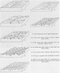 Illustrative Overview of The Cycle of Erosion. (Source: Arthur N., 1951, Physical Geography, Wiley, p. 167)
 In simplified form, the cycle of erosion theory involves periods of uplift, youth, maturity and old age, followed by more uplift. It applies mainly to humid landscapes in temperate regions where streams are the dominant agent of erosion. A peneplain is an almost flat surface near base level, sea level in most cases. A useful starting point in explaining the cycle of erosion is when a peneplain undergoes a period of rapid uplift. This is followed by youth, where streams become established and erode down toward base level. Much of the original flat surface remains and is not drained by the streams. Over time, the main streams have cut close to base level and a more extensive tributary network is established. In maturity, the stream valleys have widened so that the original flat surface has been eroded everywhere and streams drain the entire landscape. The streams become graded, meaning that there is a balance between erosion and deposition all along their lengths and valley floors become wider as the streams begin to meander. In addition, the hillsides slowly become less steep. Given enough time, the landscape will be denuded to old age, a low relief surface near base level with low hills where mountains used to stand. With the entire land surface close to base level, running water has little power to move sediment and deep soils develop. Given enough time, the old age stage merges into a peneplain and uplift occurs again.
This version of the cycle allowed Davis to introduce it as a simple and elegant scheme. As such, it could be understood by other researchers and by students in the classroom. He was fully aware that uplift does not have to be rapid and that it does not have to wait for the peneplain stage to have been achieved. Base level changes and climatic variations are other complicating factors. Much of his work for the rest of his life involved the cycle in more complicated situations and in describing cycles in other environments.
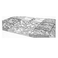 Evolution of a hypothetical landscape from younger (top) to older (bottom). (Source: W. M., 1924, Erklardende Beschreibung der Landformen 2nd ed., Verlag, p. 166)
 By 1900, the cycle of erosion was embraced by most geomorphologists and for the next fifty years, Davisian “denudation chronology” dominated geomorphology in most of the English speaking countries, especially the United States and England, and also in France. Davis’s many followers used the cycle concept to explain landscape change around the world. Geologist R. D. Salisbury of the University of Chicago was an influential critic, but most of the criticism came from a group of German physiographers, most notably the father and son Albrecht and Walther Penck. Davis and the Pencks were close friends, both personally and professionally, but differences in how they approached their research and the refusal of the Pencks to embrace the cycle of erosion wholeheartedly took its toll on their friendship over time. The First World War helped sour their relationship, as well.
Davis knew that the idealized cycle of erosion was too simple for most real world situations though his detractors did not always appreciate this fact. Neither did some of his followers.
Davis's Legacy
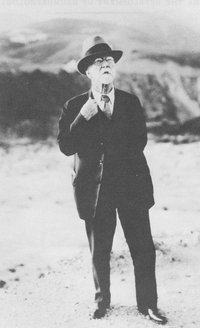 William Morris Davis studying marine terraces in Los Angeles, 1931. (Source: Chorley et al., 1973)
 Davis’s leadership in academic geography helped establish it as a distinct discipline in American universities. His personal research contributions have not, though, passed the test of time. The cycle of erosion has little influence on geomorphologists today. His disciples continued to use the theory after his death, but the next generation studied the landscape differently. During the Second World War few academics were doing traditional research for at least five years and that provided an opportunity for a change in the ‘mind-set’ of the discipline. After the War, geomorphologists put more emphasis on the processes acting on the landscape, seeking to understand how streams erode, transport and deposit sediment, for example. Much more quantitative work, especially statistical studies, were undertaken. In addition, the scale of study for most researchers shrunk from regions to localities. The development of plate tectonics theory and other geophysical advances greatly improved our understanding of uplift and other crustal changes that take place. Radiometric and other dating techniques allow vastly improved timelines of landscape change. The geomorphologists studying regional landscape change today find little in Davis’s cycle to guide their research. Their simulation models are far different from Davis’s descriptive one. Nevertheless, Davis played a profound role in the history of the discipline.
Further Reading
- Chorley, Richard J., Robert P. Beckinsale, and Antony J. Dunn. 1973. The History of the Study of Landforms or the Development of Geomorphology, Volume Two: The Life and Work of William Morris Davis. Methuen and Co., London, 874 p.
- Davis, William Morris. 1909. Geographical Essays. (Douglas Wilson Johnson, ed.) Dover Publications, 777 p.
- Orme, Antony. 2008. The Rise and Fall of the Davisian Cycle of Erosion: Prelude, Fugue, Coda, and Sequel. Physical Geography, v. 28, p. 474-506.