Cocos (Keeling) Islands
| Topics: |

Source; NASA
Countries and Regions of the World Collection  The Cocos Islands (or Keeling Islands) (Keeling) are a group of 27 coral islands in the Indian Ocean, southwest of Indonesia (1000 km southwest of western Java), about halfway between Australia and Sri Lanka (Sri Lanka).
The islands are home to about 600 people.
There are actually two separate island groups: 1.1 km2 North Keeling Island is about 25 km north of the main horseshoe-shaped atoll.
The islands are thickly covered with coconut palms and other vegetation.

Freshwater resources are limited to rainwater accumulations in natural underground reservoirs.
|
|

Captain William Keeling discovered the islands in 1609, but they remained uninhabited until the 19th century.
From the 1820s to 1978, members of the Clunie-Ross family controlled the islands and the copra produced from local coconuts. Annexed by the UK in 1857, the Cocos Islands were transferred to the Australian Government in 1955. The islands are non-self governing territory of Australia; administered from Canberra by the Department of Regional Australia, Regional Development and Local Government.
The islands were the site of a World War I naval battle in November 1914 between the Australian light cruiser HMAS Sydney and the German raider SMS Emden; after being heavily damaged in the engagement, the Emden was beached by her captain on North Keeling Island.
The population on the two inhabited islands generally is split between the ethnic Europeans on West Island and the ethnic Malays on Home Island.
Geography
Location: Southeastern Asia, group of islands in the Indian Ocean, southwest of Indonesia, about halfway between Australia and Sri Lanka
Geographic Coordinates: 12 30 S, 96 50 E
Area: 14 sq km (includes the two main islands of West Island and Home Island)
Coastline: 26 km
Maritime Claims:
territorial sea: 12 nm
exclusive fishing zone: 200 nm
Natural Hazards: cyclone season is October to April
Terrain: flat, low-lying coral atolls. The highest point is an unnamed location (5 m)
Climate: tropical with high humidity, moderated by the southeast trade winds for about nine months of the year
Legal System: common law based on the Australian model
Population: 596 (July 2010 est.)
Natural Resources: fish
Economy: Coconuts, grown throughout the islands, are the sole cash crop. Small local gardens and fishing contribute to the food supply, but additional food and most other necessities must be imported from Australia. There is a small tourist industry.
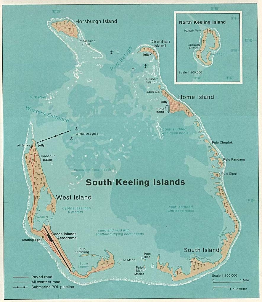
1976 Map of Cocos (Keeling) Islands in the Indian Ocean. Taken from Perry-Castañeda Library (PCL), originally from CIA Indian Ocean Atlas.
Each island group sits atop a volcanic seamount in the Vening Meinesz chain. As the seamounts have subsided downward, reef-building has maintained land near the sea surface such that the coral rock is built up 0.5-1.0 km thick over the igneous base. However, coral growth has not always kept pace with changes in sea level and all land in the islands was submerged as recently as 4000 BP. Currently, the highest point is atop a 9 m sand dune and soils are based mostly on coral, guano, and pumice washed ashore after volcanic eruptions nearby. The southern islands encircle a large lagoon that ranges in depth from 1 m in the southern end to 15 m in the north. The islands are tropical with mean daily temperatures ranging from 26-280 C. Southeast trade winds are fairly constant with an average rainfall of over 2100 mm falling predominantly between January and September when cyclones also occur.
Ecology and Biodiversity
While almost all natural forests in the Cocos southern atoll have been replaced with coconut plantation or other introduced species, the vegetation on North Keeling Island remains fairly intact and is probably representative of the flora that used to exist throughout the island group. Pisonia grandis forest up to 25 m tall dominates sheltered areas with low numbers of Laportea aestuans, Canavalia cathartica, and Erythrina variegata.
In more exposed areas strand forest is dominated by coconut (Cocos nucifera), Calophyllum inophyllum, Argusia argentea, Cordia subcordata and an endemic pandanus subspecies (Pandanus tectorius cocosensis), with Scaevola taccada, Suriana maritime, and Hibiscus tiliaceus present as shrubs. Herbfields dominated by Stenotaphrum micranthum, Lepturus repens, and Ipomoea pes-capreae are present at the tops of numerous ocean beaches. Most plant species in the Cocos Islands are widespread species from Indian and Pacific Ocean strand communities.
Although the Cocos Islands are the most isolated tropical islands in the Indian Ocean their isolation has not resulted in high levels of endemism. This is probably the result of the submergence of all land in the islands within the last 4000 years and frequent catastrophic cyclones that inundate much of the land. They support 121 vascular plant species, including 57 introduced species, and at least 14 seabird species. The only two forest birds are an endemic subspecies of the buff-banded rail (Rallus phillippensis andrewsi) and the Christmas Island white-eye (Zosterops natalis) which was introduced between 1885-1900. The Cocos Islands support at least 9 species of terrestrial crab including the coconut crab (Birgus latro) and the Christmas Island red crab (Gecarcoidea natalis), introduced earlier this century. Terrestrial crabs only occur in significant numbers on North Keeling Island where they quickly consume fruit, seeds, seedlings, and leaf litter keeping the forest floor open.
See: Christmas and Cocos Islands tropical forests