Dry Climates - B Climate Type
Contents
Introduction
The most obvious feature of this category of the Köppen Climate Classification System, the Dry Climates - B Climate Type, is that potential evapotranspiration exceeds precipitation. These Köppen climate types extend from 20 to 35° North and South of the equator and in large continental regions of the mid-latitudes often surrounded by mountains.
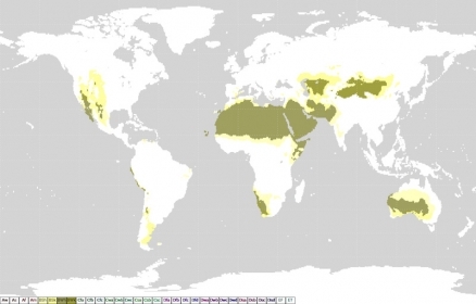
See link for high reslution Köppen Climate Map to see the spatial distribution of the B climate type.
Four minor types of this climate occur:
BW - Dry Arid (Desert)
BW is a true desert climate. It covers 12% of the Earth's land surface and is dominated by xerophytic vegetation. The additional letters h and k are used generally to distinguish whether the dry arid climate is found in the subtropics or in the mid-latitudes, respectively.
BWh – Dry Arid Low Latitudes
BWh is a dry arid climate found in low latitude deserts. The most distinguishing aspect of this climate is that precipitation is less than 50% of potential evapotranspiration. Annual average temperature is over 18°C (64°F). Daily minimum temperatures infrequently go below 0°C (32°F) during the winter season.
Locations: Northern Mexico, southwestern United States, northern Africa Saudi Arabia, Iran, western India, central and western Australia, and southern and western Africa.
BWk – Dry Arid Mid-Latitudes
BWk is a dry arid climate found in middle latitude deserts. Like BWh, precipitation is less than half of potential evapotranspiration. Annual average temperature is below 18°C (64°F). Daily minimum temperatures can frequently go below 0°C (32°F) during the winter season.
Locations: From the Caspian Sea eastward to northern China, Mongolia, and parts of southern South America.
Controlling Weather Factors (both BWh and BWk): Dominance of the Subtropical High Pressure Zone during most of the year. Locations are often far inland (continentality) and influenced by rainshadow effect.
Climate Characteristics (both BWh and BWk): Climate is very arid and air has low relative humidity. Rainfall is very irregular and unreliable. Annual rainfall totals less than 250 mm (10 in.). BWh/k has the highest percentage of sunshine of all climate types. Diurnal (day to night) temperature ranges are the greatest of all climate types. Daily maximum temperatures are very high. Generally, windy conditions persist during the day.
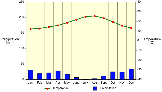
Example:
 Figure 1. BWh - Almeria, Spain 37° N , Elevation: 7 m (23 ft). (image Copyright: Michael Pidwirny).
BS - Dry Semiarid (Steppe)
This is a grassland climate that covers 14% of the Earth's land surface. It receives more precipitation than the BW either from short incursions of the Intertropical Convergence Zone or from occasional mid-latitude cyclones. Once again, the additional letters h and k are used generally to distinguish whether the dry semiarid climate is found in the subtropics or in the mid-latitudes, respectively.
BSh – Semiarid Low Latitudes
BSh is a semiarid climate found in the low latitudes. Potential evapotranspiration exceeds precipitation on average but the difference between these two measures is less than what is found in a BWh climate. Annual average temperature is over 18°C (64°F). Annual precipitation totals greater than BWh climate.
Locations: About 13 to 15° North latitude in Africa, about 20° South latitude southern Africa, border areas around Australian desert, parts of southern South America, parts of India, and areas marginal to BWh climates of northwestern Africa, Saudi Arabia, and western India.
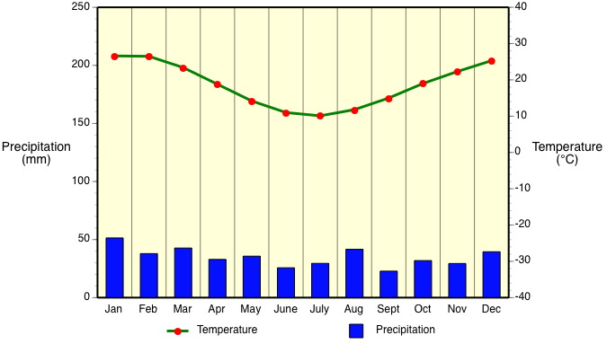
Example:
 Figure 2. BSh - Cobar, Australia 31° N , Elevation: 264 m (866 ft). (image Copyright: Michael Pidwirny).
BSk – Semiarid Mid-Latitudes
BSk is a semiarid climate usually found in the middle latitudes. Potential evapotranspiration exceeds precipitation on average but the difference between these two measures is less than what is found in a BWk climate. Annual average temperature is below 18°C (64°F).
Locations: Western plains of the United States, south-central Canada, and borders BWh climate areas from the Caspian Sea eastward to China and Mongolia.
Controlling Weather Factors (both BSh and BSk): Weather is transitional between deserts and humid climates. Dominance of the Subtropical High Pressure Zone occurs during most of the year. Precipitation comes from brief incursions of the Intertropical Convergence Zone or from sporadic mid-latitude cyclones. Locations are often far inland (continentality) and influenced by rain shadow effect.
Climate Characteristics (both BSh and BSk): Climate is arid and air has low relative humidity. Rainfall is sporadic. Annual rainfall totals between 250 and 500 mm (10 and 20 in.). Air temperatures vary greatly because of the effects of latitude, elevation, and continentality.
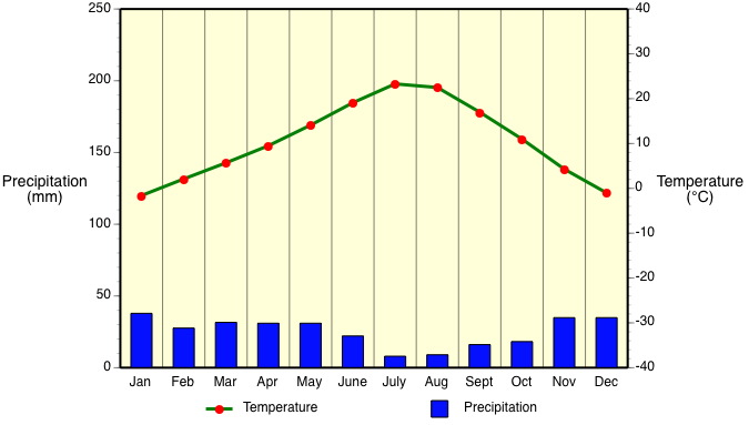
Example:
 Figure 3. BSk - Boise, Idaho, USA 44° N , Elevation: 865 m (2838 ft). (image Copyright: Michael Pidwirny).
Online Köppen Maps
References
- Aguado, E. and James E. Burt. 2010. Understanding Weather and Climate. Fifth Edition. Prentice Hall, Upper Saddle River, New Jersey.
- Ahrens, C. D. 2006. Meteorology Today. An Introduction to Weather, Climate, and the Environment. Eighth Edition. Thompson, Brooks/Cole. USA.
- Lutgens, F.K. and E.J. Tarbuck. 2004. The Atmosphere: An Introduction to Meteorology. NinthEdition. Prentice Hall, Upper Saddle River, New Jersey.
- Lydolph, P.E. 1985. The Climate of the Earth. Rowman and Allanheld Publishers, Totowa, New Jersey.
- Oliver, J.E. and J.J. Hidore. 2002. Climatology: An Atmospheric Science. Second Edition. Prentice Hall, Upper Saddle River, New Jersey.
- Peel, Murray C. 2011. Updated Köppen-Geiger Climate Map of the World. http://people.eng.unimelb.edu.au/mpeel/koppen.html
