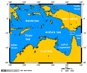
Arafura Sea

The Arafura Sea is part of the southeastern Australasian Mediterranean Sea centered at about 10oS and 137o E. It is bounded by Irian Jaya and Papua/New Guinea to the north and northeast, the Timor Sea to the west, and Australia and the Gulf of Carpenteria to the south and the southeast. It is mostly a large shelf (covering about 650,000 km2) ranging from 50 to 80 meters (m) deep, although it can get as deep as 3650 m to the northwest in the Aru Basin.
| This article is written at a definitional level only. Authors wishing to expand this entry are inivited to expand the present treatment, which additions will be peer reviewed prior to publication of any expansion. |
There is a steady westward flow along the southern side of the Sunda Islands that is part of the larger pattern of throughflow through the Australasian Mediterranean from the Pacific to the Indian Ocean. South of this the circulation varies with the monsoon and trade winds that drive it. The deep water is renewed from the northwest via the Timor Trough.
Sea surface temperatures range from a maximum of 28.4oin Dec.-Feb. to a minimum of 26.1o in Jun.-Aug., while salinities annually range from 34.2-34.8 in the deeper parts to the north to 34.2 to 35.0 on the Arafura Shelf.
Further Reading:
- Physical Oceanography Index
- Seas of the world
- Rhodes W. Fairbridge, editor. The Encyclopedia of Oceanography. Van Nostrand Reinhold Co., 1966.
- Matthias Tomczak and J. Stuart Godfrey. Regional Oceanography: An Introduction. Pergamon, 1994.