Vanuatu
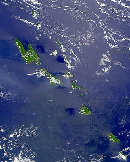
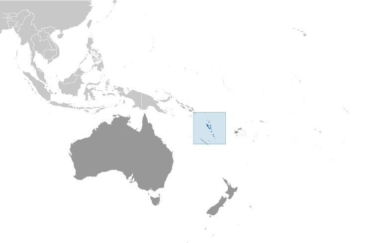
Countries and Regions of the World Collection  Vanuatu (formerly New Hebrides), is a nation of under a quarter million people composed of group of more than 80 islands, about 65 of which are inhabited, in the South Pacific Ocean, north of New Caledonia about three-quarters of the way from Hawaii to Australia.
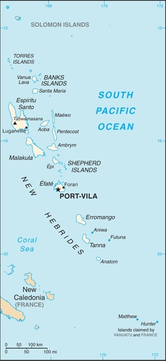
Geographically, Vanuatu is a Y-shaped chain of four main islands and 80 smaller islands; several of the islands have active volcanoes.
Its major environmental issues include:most of the population does not have access to a reliable supply of potable water;and, deforestation
Multiple waves of colonizers, each speaking a distinct language, migrated to the New Hebrides in the millennia preceding European exploration in the 18th century. This settlement pattern accounts for the complex linguistic diversity found on the archipelago to this day.
The British and French, who settled the New Hebrides in the 19th century, agreed in 1906 to an Anglo-French Condominium, which administered the islands until independence in 1980, when the new name of Vanuatu was adopted.
Matthew and Hunter Islands east of New Caledonia claimed by Vanuatu and France.
Contents
Geography
Location: Oceania, group of islands in the South Pacific Ocean, about three-quarters of the way from Hawaii to Australia
Geographic Coordinates: 16 00 S, 167 00 E
Area: 12,189 sq km Note: includes more than 80 islands, about 65 of which are inhabited
Coastline: 2,528 km
Maritime Claims:
measured from claimed archipelagic baselines
territorial sea: 12 nm
contiguous zone: 24 nm
exclusive economic zone: 200 nm
continental shelf: 200 nm or to the edge of the continental margin
Natural Hazards: tropical cyclones or typhoons (January to April); volcanic eruption on Aoba (Ambae) island began on 27 November 2005, volcanism also causes minor earthquakes; tsunamis
Volcanism: Vanuatu is the result of the subduction of the northward-moving Australian tectonic plate beneath the Pacific plate, and the islands are a very active tectonic area. Most of the surface geology of the islands consists of Pliocene-Pleistocene volcanic rocks and uplifted coral. Vanuatu experiences significant volcanic activity, with many volcanoes erupting in recent years; Yasur (elev. 361 m), one of the world's most active volcanoes, has experienced continuous activity in recent centuries; other historically active volcanoes include, Aoba, Ambrym, Epi, Gaua, Kuwae, Lopevi, Suretamatai, and Traitor's Head
Terrain: mostly mountainous islands of volcanic origin; narrow coastal plains. The highest point is Tabwemasana (1,877 m).
Climate: tropical; moderated by southeast trade winds from May to October; moderate rainfall from November to April; may be affected by cyclones from December to April
Ecology and Biodiversity
Ecologically, Vanuatu is included within the Vanuatu rain forests ecoregion which consists of tropical lowland and montane forests in the island nation of Vanuatu, with the addition of the Santa Cruz Group, or Temotu Province of the Solomon Islands.. The islands contain fifteen bird species and several mammal species found nowhere else in the world. Although it is faced with population pressures and regular visits by destructive cyclones, with few exceptions Vanuatu's natural heritage is nearly intact.
Ninety percent of the population is engaged in subsistence farming in rural areas, and 41 percent of the nation of Vanuatu is considered to have average or better agricultural suitability. This fertile land is not spread evenly among the islands, however. There is a growing emphasis on cash crops (cocoa, copra), and clearing for plantations and cattle has occurred. Commercial logging has intensively focused on two species: kauri (Agathis macrophylla) and sandalwood (Santalum austrocaledonicum). Sandalwood was almost eliminated by the end of the nineteenth century.
Severe cyclones, volcanic eruptions, and earthquakes are regular events in Vanuatu, and although these are natural events, their effects can be exacerbated by human disturbance of watersheds and remaining forest areas.
There are no protected areas in Vanuatu. Establishing protected areas is problematic because of customary land rights: 99 percent of the land is owned by village people.
See also: Biological diversity in the East Melanesian Islands
People and Society
Population: 227,574 (July 2012 est.)
Ethnic Groups: Ni-Vanuatu 98.5%, other 1.5% (1999 Census)
Age Structure:
0-14 years: 29.6% (male 33,968/female 32,550)
15-64 years: 66.1% (male 75,559/female 72,919)
65 years and over: 4.3% (male 4,862/female 4,706) (2011 est.)
Population Growth Rate: 1.321% (2012 est.)
Birthrate: 20.6 births/1,000 population (2012 est.)
Death Rate: 7.39 deaths/1,000 population (July 2012 est.)
Net Migration Rate: 0 migrant(s)/1,000 population (2012 est.)
Life Expectancy at Birth: 65.06 years
male: 63.38 years
female: 66.83 years (2012 est.)
Total Fertility Rate: 2.35 children born/woman (2012 est.)
Languages: local languages (more than 100) 72.6%, pidgin (known as Bislama or Bichelama) 23.1%, English (official) 1.9%, French (official) 1.4%, other 0.3%, unspecified 0.7% (1999 Census)
Literacy (age 15 and over can read and write): 74% (1999 census)
Urbanization: 26% of total population (2010) growing at an annual rate of change 4.2% (2010-15 est.)
Access to improved sources of drinking water: 83% of population
Access to improved sanitation facilities: 52% of population
Government
Government Type: parliamentary republic
Capital: Port-Vila (on Efate)
Administrative divisions: 6 provinces; Malampa, Penama, Sanma, Shefa, Tafea, Torba
Independence Date: 30 July 1980 (from France and the UK)
Legal System: mixed legal system of English common law, French law, and customary law. Vanuatu has not submitted an International Court of Justice (ICJ) jurisdiction declaration; and is a non-party state to the International criminal court (ICCt).
International Environmental Agreements
Vanuatu is party to international agreements on: Antarctic-Marine Living Resources, Biodiversity, Climate Change, Climate Change-Kyoto Protocol, Desertification, Endangered Species, Law of the Sea, Marine Dumping, Ozone Layer Protection, Ship Pollution, and Tropical Timber 94.
Resources
Natural Resources: manganese, hardwood forests, fish
Land Use:
arable land: 1.64%
permanent crops: 6.97%
other: 91.39% (2005)
Economy
This South Pacific island economy is based primarily on small-scale agriculture, which provides a living for about two-thirds of the population.
Fishing, offshore financial services, and tourism, with nearly 197,000 visitors in 2008, are other mainstays of the economy.
Mineral deposits are negligible; the country has no known petroleum deposits.
A small light industry sector caters to the local market.
Tax revenues come mainly from import duties.
Economic development is hindered by dependence on relatively few commodity exports, vulnerability to natural disasters, and long distances from main markets and between constituent islands.
In response to foreign concerns, the government has promised to tighten regulation of its offshore financial center.
In mid-2002, the government stepped up efforts to boost tourism through improved air connections, resort development, and cruise ship facilities.
Agriculture, especially livestock farming, is a second target for growth. Australia and New Zealand are the main suppliers of tourists and foreign aid.
GDP: (Purchasing Power Parity): $1.224 billion (2011 est.)
GDP: (Official Exchange Rate): $800 million (2011 est.)
GDP- per capita (PPP): $4,900 (2011 est.)
GDP- composition by sector:
agriculture: 21.2%
industry: 10.4%
services: 68.4% (2011 est.)
Agricultural products: copra, coconuts, cocoa, coffee, taro, yams, fruits, vegetables; beef; fish
Industries: food and fish freezing, wood processing, meat canning
Currency: Vatu (VUV)


