Subduction (Environmental & Earth Science)
Contents
Subduction
| Topics: |
Geology (main)
|
Source: NASA
Introduction
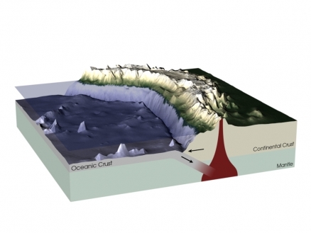
Subduction is a term used in earth science to describe the process where of the oceanic lithosphere (the outer solid part of the Earth, including the crust and uppermost mantle, about 100 km thick) collides with and descends beneath the part of the lithosphere. In terms of tectonics, subduction is the result of two tectonic plates converging, and one plate sliding (subducting) under another plate. The term "subduction zone" is used to describe the region where subduction occurs and the characteristics associated with subduction are observed.
The gliding of one plate under the other is not smooth but jerky producing seismic waves. Thus, subduction is associated with earthquakes. Subduction results in the creation of molten magma that gives rises to volcanism, particularly a line of volcanoes known as "arc volcanoes" or a series of volcanic islands. Most volcanoes on land occur parallel to and inland from the boundary between the two plates.
Structure of the Earth
The Earth is composed of a number of different layers as determined by deep drilling and seismic evidence (Figure 1). These layers are:
- The core which is approximately 7000 kilometers in diameter (3500 kilometers in radius) and is located at the Earth's center.
- The mantle which surrounds the core and has a thickness of 2900 kilometers.
- The crust floats on top of the mantle and is composed of basalt rich oceanic crust and granitic rich continental crust.
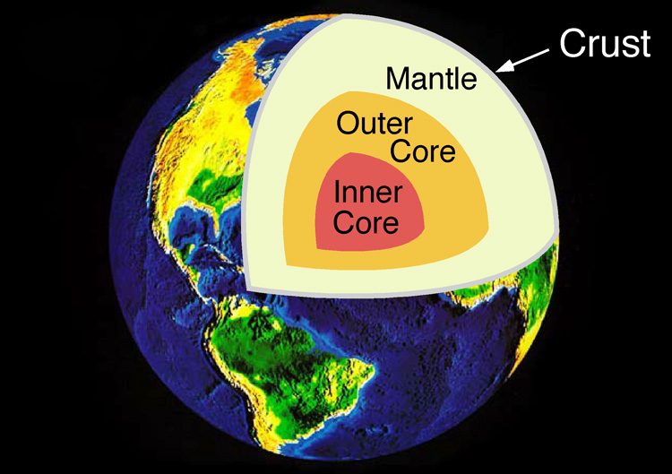 Figure 1: Layers beneath the Earth's surface. (Image Copyright: Michael Pidwirny.)
The core is a layer rich in iron and nickel that is composed of two layers: the inner and outer cores. The inner core is theorized to be solid with a density of about 13 grams per cubic centimeter and a radius of about 1220 kilometers. The outer core is liquid and has a density of about 11 grams per cubic centimeter. It surrounds the inner core and has an average thickness of about 2250 kilometers.
The mantle is almost 2900 kilometers thick and comprises about 83% of the Earth's volume. It is composed of several different layers. The upper mantle exists from the base of the crust downward to a depth of about 670 kilometers. This region of the Earth's interior is thought to be composed of peridotite, an ultramafic rock made up of the minerals olivine and pyroxene. The top layer of the upper mantle, 100 to 200 kilometers below surface, is called the asthenosphere. Scientific studies suggest that this layer has physical properties that are different from the rest of the upper mantle. The rocks in this upper portion of the mantle are more rigid and brittle because of cooler temperatures and lower pressures. Below the upper mantle is the lower mantle that extends from 670 to 2900 kilometers below the Earth's surface. This layer is hot and plastic. The higher pressure in this layer causes the formation of minerals that are different from those of the upper mantle.
The lithosphere is a layer that includes the crust and the upper most portion of the asthenosphere (Figure 2). This layer is about 100 kilometers thick and has the ability to glide over the rest of the upper mantle. Because of increasing temperature and pressure, deeper portions of the lithosphere are capable of plastic flow over geologic time. The lithosphere is also the zone of earthquakes, mountain building, volcanoes, and continental drift.
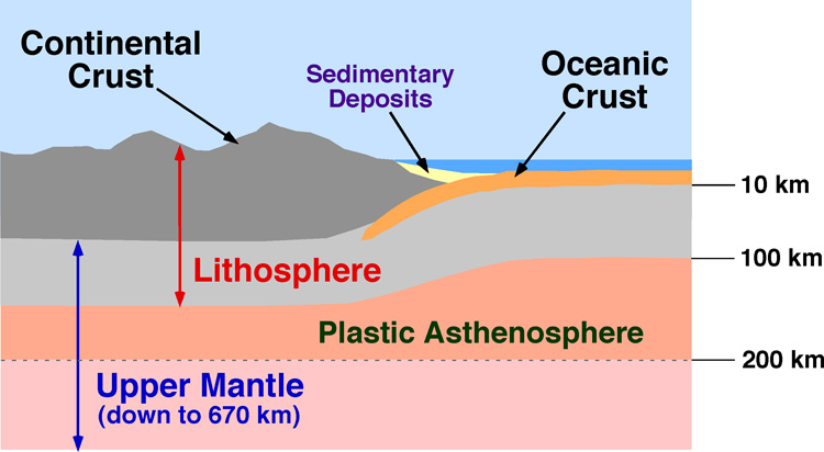 Figure 2: Structure of the Earth's crust and top most layer of the upper mantle. The lithosphere consists of the oceanic crust, continental crust, and uppermost mantle. Beneath the lithosphere is the asthenosphere. This layer, which is also part of the upper mantle, extends to a depth of about 200 kilometers. Sedimentary deposits are commonly found at the boundaries between the continental and oceanic crust. (Image Copyright: Michael Pidwirny.)
The topmost part of the lithosphere consists of crust. This material is cool, rigid, and brittle. Two types of crust can be identified: oceanic crust and continental crust (Figure 2). Both of these types of crust are less dense than the rock found in the underlying upper mantle layer. Ocean crust is thin and measures between 5 to 10 kilometers thick. It is also composed of basalt and has a density of about 3.0 grams per cubic centimeter.
The continental crust is 20 to 70 kilometers thick and composed mainly of lighter granite (Figure 2). The density of continental crust is about 2.7 grams per cubic centimeter. It is thinnest in areas like the Rift Valleys of East Africa and in an area known as the Basin and Range Province in the western United States (centered in Nevada this area is about 1500 kilometers wide and runs about 4000 kilometers North/South). Continental crust is thickest beneath mountain ranges and extends into the mantle. Both of these crust types are composed of numerous tectonic plates that float on top of the mantle. Convection currents within the mantle cause these plates to move slowly across the asthenosphere
Subduction Process
Subduction occurs because of differences in density of continental and ocean plates. Density differences occur because the lithosphere becomes thicker and denser as it ages. As a result, the lighter crustal plates subduct into the asthenosphere and, when plates converge, the plate with the older lithosphere subducts under the plate with the denser lithosphere. Because oceanic lithosphre is lighter than continental lithosphere, oceanic plates subduct under continental plates when they converge (middle diagram to the right).
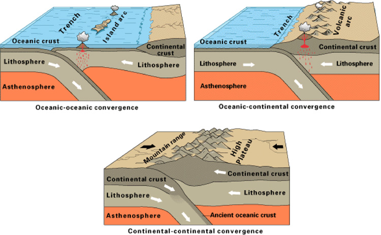 Figure 3: Three types of plate convergance resulting in subduction. (Image Source. US Gelogical Survey.)
A typical speed for a subducted plate is about 7 cm/year.
As the subducted plate moves deeper, it releases water which rises up and moves into the overlying plate where magma (more specifically, peridotite) begins to melt ("wet" peridotite melts as a temperatures up to 400°C lower that "dry" peridotite.) This molten magma drives the arc volcanoes characteristic of subduction zones.
Geologic Features Associated With Subduction
Some characteristics of subduction and subduction zones are:
- A zone of earthquakes (Wadati-Benioff Zones) where the depth of the earthquake hypocenters vary in accordance to the geometry of a subducted plate;
- Deep sea trenches like the the Marianas trench in the Pacific Ocean which is created by the collision of the fast-moving Pacific Plate against the slower moving Philippine Plate;
- Chains of volcanoes called "arc volcanoes" which can be islands or near the coast.
Trenches and arc volcanoes often occur along a parallel line, marking the location of the subduction zone.
The Cascadia Subduction Zone
|
|
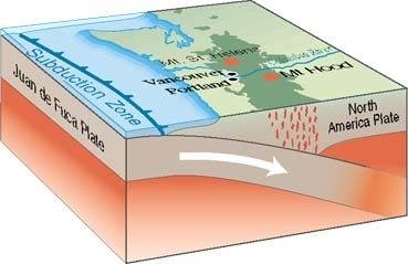
The Cascadia Subduction Zone illustrated right is caused by the subduction of the Juan de Fuca plate beneath North America. It extends over a region 600 miles long that includes northern California, Oregon, Washington, and southern British Columbia. The nature of the subduction changes markedly along the length of the subduction zone, notably in the angle of subduction, distribution of earthquakes, volcanism, geologic and seismic structure of the upper plate, and regional horizontal stress. Research by the US Geological Survey reveals that downgoing slab of the Cascadia subduction zone dips significantly steeper beneath Oregon than beneath Vancouver Island, lending support to the idea that the Juan de Fuca plate is segmented from north to south.
The Cascadia Subduction Zone was the site of the largest known earthquake to have occurred in the "lower 48" United States. The earthquake set off a tsunami that not only struck Cascadia's Pacific coast, but also crossed the Pacific Ocean to Japan, where it damaged coastal villages. Written records of the damage in Japan pinpoint the earthquake to the evening of January 26, 1700.
Natural Resources Canada reports that:
"The undersea Cascadia thrust fault ruptured along a 1000 km length, from mid Vancouver Island to northern California in a great earthquake, producing tremendous shaking and a huge tsunami that swept across the Pacific.
The earthquake shaking collapsed houses of the Cowichan people on Vancouver Island and caused numerous landslides. The shaking was so violent that people could not stand and so prolonged that it made them sick. On the west coast of Vancouver Island, the tsunami completely destroyed the winter village of the Pachena Bay people with no survivors. These events are recorded in the oral traditions of the First Nations people on Vancouver Island. The tsunami swept across the Pacific also causing destruction along the Pacific coast of Japan. It is the accurate descriptions of the tsunami and the accurate time keeping by the Japanese that allows us to confidently know the size and exact time of this great earthquake.

The earthquake also left unmistakeable signatures in the geological record as the outer coastal regions subsided and drowned coastal marshlands and forests that were subsequently covered with younger sediments. The recognition of definitive signatures in the geological record tells us the January 26, 1700 event was not a unique event, but has repeated many times at irregular intervals of hundreds of years. Geological evidence indicates that 13 great earthquakes have occurred in the last 6000 years.
We now know that a similar offshore event will happen sometime in the future and that it represents a considerable hazard to those who live in southwest British Columbia. However, because the fault is offshore, it is not the greatest earthquake hazard faced by major west coast cities. In the interval between great earthquakes, the tectonic plates become stuck together, yet continue to move towards each other. This causes tremendous strain and deformation of the Earth's crust in the coastal region and causes ongoing earthquake activity. This is the situation that we are in now. Some onshore earthquakes can be quite large (there have been four magnitude 7+ earthquakes in the past 130 years in southwest British Columbia and northern Washington State). Because these inland earthquakes can be much closer to our urban areas and occur more frequently, they represent the greatest earthquake hazard. An inland magnitude 6.9 earthquake in 1995 in a similar geological setting beneath Kobe, Japan caused in excess of $200 billion damage."
March 11, 2011 Earthquake East of Japan
A major earthquake (preliminary magnitude 8.9) near the east coast of Honshu, Japan, occurred on March 11, 2011, as a result of thrust faulting on or near the subduction zone interface plate boundary between the Pacific and North America plates. At the latitude of this earthquake, the Pacific plate moves approximately westwards with respect to the North America plate at a velocity of 83 mm/yr. The Pacific plate thrusts underneath Japan at the Japan Trench, and dips to the west beneath Eurasia. The location, depth, and focal mechanism of the March 11 earthquake are consistent with the event having occurred as thrust faulting associated with subduction along this plate boundary. Note that some authors divide this region into several microplates that together define the relative motions between the larger Pacific, North America and Eurasia plates; these include the Okhotsk and Amur microplates that are respectively part of North America and Eurasia.
The March 11 earthquake was preceded by a series of large foreshocks over the previous two days, beginning on March 9th with an Magnitude (M) 7.2 event approximately 40 km from the March 11 earthquake, and continuing with a further 3 earthquakes greater than M 6 on the same day.
The Japan Trench subduction zone has hosted 9 events of magnitude 7 or greater since 1973. The largest of these was an M 7.8 earthquake approximately 260 km to the north of the March 11 event, in December 1994, which caused 3 fatalities and almost 700 injuries. In June of 1978, an M 7.7 earthquake 35 km to the southwest caused 22 fatalities and over 400 injuries.
Further Reading
- Natural Resources Canada, The M9 Cascadia Megathrust Earthquake of January 26, 1700, .
- PhysicalGeography.net
- Stern, R. J. "A Subduction Primer for Instructors of Introductory Geology Courses and Authors of Introductory Geology Textbooks." J. Geoscience Education, 46, 221-228.
- Tatsumi, Y. (2005). "The Subduction Factory: How it operates on Earth". GSA Today 15 (7): 4–10. doi:10.1130/1052-5173(2005)015[4:TSFHIO]2.0.CO;2.
- US Geological Survey, Cascadia Subduction Zone: Two Contrasting Models of Lithospheric Structure.
- US Geological Survey, Earthquake Glossary - Subduction Zone.
- US Geological Survey, Historic Earthquakes: Cascadia Subduction Zone.
- US Geological Survey, Magnitude 8.9 - Near the East Coast of Honshu, Japan.
 Public Domain Image