Songhua River
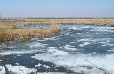
Icy early spring floodplain, Songhua Basin, northeast of Harbin. @ C.Michael Hogan
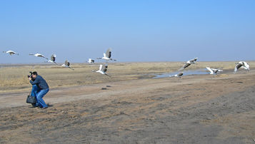 Red-crowned Cranes in Songhua Basin, northeast of Harbin. @ C. Michael Hogan The Songhua River, draining a sizable area of northeastern China, is the chief tributary of the Amur River, and is the 65th largest river in the world. The Songhua runs a total length of 1927 kilometres, when its longest tributary, the Nenjiang River, is included; the Nenjiang drains the North Manchurian Plain and the Nenjiang River grasslandecoregion. The lowland floodplain area of the Songhua Basin is a vast level expanse that has invited meandering of the river channels and also invited agricultural exploitation.
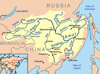 Songhua River in context with the larger Amur Basin. cc-3.0 The size of the catchment of the Songhua River is approximately 1,444,000 square kilometres. The Songhua Basin is a significant habitat area for the migrating Red-crowned Crane, as well as other rare crane species. There have been prior episodes of contamination of the Songhua River, most notably a large scale benzene spill; moreover, river water quality has been degraded by widespread runoff of nitrates, phosphates, pesticides and herbicides associated with agricultural intensification in the basin.
Hydrological and coupled basin meteorology models for the Songhua Basin developed by Wang et al. evince good agreement with historical data; in a search for future basin outcomes a number of future climate scenarios were run, in order to understand likely basin outcomes for river flow and agricultural supply. Most of the scenarios included aggressive assumptions for future global and regional temperature rise scenarios, and model predictions generally show increases in river discharge and expanded water quantities for agricultural use; the model runs predicted increases in precipitation, which more than overcome evapotranspiration increases. The results, however, imply that the Chinese will need to capitalise on this potential benefit of water resource expansion by proper crop selection and avoidance of crop flooding on the low lying areas.
Contents
Nenjiang River tributary
The Nenjiang River rises in the Daxingan Mountains; the terrestrial basin of the Nenjiang River (also termed the Nen River) is chiefly characterised by the [[Nenjiang River grassland]ecoregion], an expansive low lying grassland. The basin's rich soils have inticed intensive agricultural exploitation, and the ecoregion also suffers from overfishing. The Nenjiang Basin is circumscribed by low mountains, the Large Hinggan to the west and the Little Hinggan to the north. Higher mountain landforms that define the northern extent of the Korean Peninsula demarcate the southern margin of the Nenjiang Plain.
The Nenjiang River is the longest influent element for the Songhua River. Its [catchment] is a breeding habitat for a number of rare and endangered cranes including the Critically Endangered Siberian Crane (Grus leucogeranus), the Endangered Red-crowned Crane (Grus japonensis), the Vulnerable White-naped Crane (Grus vipio); the Demoiselle Crane (Grus virgo) is also found in the Nenjiang Basin.
Other notable bird species breeding in the Nenjiang Basin are White Stork (Ciconia ciconia), Black Stork (C. nigra), Oriental White Ibis (Threskiornis aethiopicus melanocephalus), Great Bustard (Otis tarda, VU), Mandarin Duck (Aix galericulata), and Eurasian Spoonbill (Platalea leucorodia).
Notable mammals in the Nenjiang Basin include the Dhole (Cuon alpinus, EN), the Corsac Fox (Vulpes corsac), the Siberian Large-toothed Shrew (Sorex daphaenodon), the Manchurian Hare (Lepus mandshuricus) and a variety of other carnivores and herbivores. This basin is quite depauperate with respect to reptiles.
Typical vegetation in the lowlands of the Nenjiang River Basin consists of a distinctive coniferous swamp forest interspersed among meadows dominated by grasses and sedges. Forests are dominated by the Daurian Larch (Larix gmelini ssp. olgensis) which may penetrate a lower story of Japanese White Birch (Betula platyphylla subsp. mandshurica). Meadows are dominated by grasses such as Chee Reed Grass (Calamagrostis epigeios) and another boreal reedgrass, C. purpurea, that are adapted to grow in flooded soils. Such ground cover often manifests as dense tussocks that emerge from the flooded areas. Lakes are frequently filled or lined at the margin by the salt-tolerant reed, Phragmites australis.
Upper mainstem
The upper mainstem of the Songhua River is often termed the Second Songhua River (or sometimes the Ersong River); it can also be viewed as the major south fork river element joined by the Nenjiang River to form the lower reach of the Songhua. The river rises in the Changbai Mountain Range, and the chief ecoregion spanning the upper mainstem [catchment] of the Songhua is the Northeast China Plain deciduous forests. Tributaries of the Second Songhua include the First Dao, Second Dao, Huifa, Lafa, Yinma and Yitong Rivers. There are several major dams across the upper mainstem: notably the Baishan, Fengman and Hongshi Reservoirs.
Amphibians found in the upper Songhua mainstem include the Siberian Salamander (Salamandrella keyserlingii); the Long-tailed Clawed Salamander (Onychodactylus fischeri); Gensan Salamander (Hynobius leechii); and the Korean Water Toad (Bufo stejnegeri).
Some of the notable mammals found in the Second Songhua River Basin include Brandt's Vole (Lasiopodomys brandtii); the ungulate Chinese Goral (Naemorhedus caudatus, VU); the fossorial Roborovski's Desert Hamster (Phodopus roborovskii); the mouse-eared bat Far Eastern Myotis (Myotis bombinus, NT)
Reptiles found in the upper mainstem include the Amur Grass Lizard (Takydromus amurensis) and the Taiwan Beauty Snake (Orthriophis taeniurus).
Lower mainstem
The lower mainstem of the Songhua can be considered as the river below the confluence with the Nenjiang River. The initial portion of this reach flows through the Northeast China Plain deciduous forests, while the final portion (up to discharge to the Amur River) flows through the Amur Meadow Steppe. Thus flora and fauna of the initial portion of the lower mainstem are similar to those discussed above under the upper mainstem. The following discussion will focus upon the biota found in the Amur meadow steppe (i.e. the portion of the Songhua River within about 300 kilometres of the confluence with the Amur River).
Notable mammals found in the lower mainstem terrestrial environment include the Amur Hedgehog (Erinaceus amurensis); the Flat-skulled Shrew (Sorex roboratus); the broadly distributed Parti-coloured Bat (Vespertilio murinus), whose eastern range limit is the Songhua Basin.
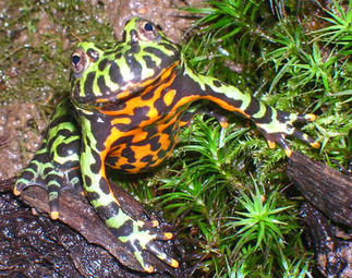 Oriental Fire-bellied Toad. Source: H.Yan/EoL Amphibian and reptilian species diversity in the lower Songhua Basin is relativley low. Amphibians occurring in the lower Songhua Basin include: Dybowski's Frog (Rana dybowskii); Oriental Fire-bellied Toad (Bombina orientalis); Mongolian Toad (Pseudepidalea raddei), whose range extends from western China and eastern Siberia to Korea and to the northeast as far as the Amur Basin.
Notable reptiles in the Amur meadow steppe in the lower Songhua Basin are: the Steppe Rat Snake (Elaphe dione) and the Ussuri Pitviper (Gloydius ussuriensis).
Water quality
The Songhua River has experienced notable episodic water pollution events, particularly in the year 2005. Particular contaminants of concern include benzene, benzopyrene, nitrobenzene, anthracene and pyrene. The 2005 incident occurred as a massive pollutant release in the Songhua River, with ensuing major health risk impacts to the downriver Russian city of Khabarovsk.
In addition to the episodic water pollution events, the Songhua Basin has experienced ongoing effluent impacts of heavy metals as well as nitrate and nitrite loading. These nitrogen loadings include effluent from industrial and municipal wastewater, as well as agricultural runoff from poorly managed application of fertiliser. Much of the municipal wastewater impact results from cities in the watershed that have inadequate sewage treatment facilities, generating considerable amounts of wastewater that is untreated or partially treated (i.e. less than secondary treatment).
Conservation
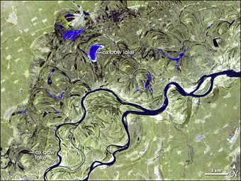 Satellite view of braided channels of the Songhua River. @ NASA Within the Nenjiang Basin, the two largest protected areas are the Zhalong Nature Reserve in Heilongjiang Province, and the Momoge Nature Reserve in Jilin Province; each of these sites consists of expansive flooded grassland.
Yiwulu Shan is a hilly area near the Northeast China Plain where a nature reserve (114 square kilometres) protects forested area resembling the prehistoric vegetation of the plain. Here, a mixture of deciduous broadleaf species and Pinus tabulaeformis is found. Forests likely represent the most intact stands in the western part of Laioning Province, and may be the closest to a surviving refugia example of the broadleaf forests that once covered the plains.
References
- Asian Development Bank. 2005. People’s Republic of China: Songhua River Basin Water Quality and Pollution Control Management: Strategic Planning Report.
- Chinese Vegetation Map Compilation Committee (CVMCC). 1979. Vegetation map of China. Map (1:10,000,000). Science Press, Beijing. ISBN: 7030089561
- Michael D.Glascocka, Yaroslav V.Kuzminb, Andrei V.Grebennikovc, Vladimir K.Popovc, Vitaly E.Medvedevd, Igor Y.Shewkomude, Nikolai N.Zaitsevf. 2011. Obsidian provenance for prehistoric complexes in the Amur River basin (Russian Far East). Journal of Archaeological Science Volume 38, Issue 8, pages 1832–1841
- Jingshuang Liu and Junbao Yu. 1999. Dynamic variation of nitrogen content in the Second Songhua River. Chinese Geographical Science. vol.9, no 4, pp 368-372
- J. MacKinnon and K. Phillipps. 2000. A Field Guide to the Birds of China. Oxford University Press, New York. ISBN: 0198549407
- X. Wang, Z. Zhou, Y. Jia, P. Hu, & Z. Cao. 2010. Study on impacts of climate change on water resources in Songhua River Basin. China Institute of Water Resources and Hydropower Research. A956
- World Wildlife Fund. 2008. Nenjiang River grassland. Topic eds. M. McGinley & C.M. Hogan. Encyclopedia of Earth. National Council for Science and the Environment. Washington DC