Marshall Islands
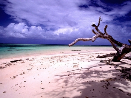
Laura Beach, the Marshall Islands. Source: Stefan Lins/Wikimedia Commons
The Marshall Islands two archipelagic island chains of 29 atolls, each made up of many small islets, and five single islands in the North Pacific Ocean, about half way between Hawaii and Australia. Just over 68,000 people live on the Marshall Islands.

The two archipelagic island chains are western Ralik, or "sunset" chain (from Eniwetok to Ebon), and the eastern Ratak, or "sunrise" chain (Taongi and Rongelap to Mili). The Marshall Islands are all low coral limestone atolls and carbonate sand islands, with a maximum elevation of 10 meters (m) on the island of Likiep. Although the archipelago consists of 30 atolls and more than 1,000 islands, and extends for roughly 1,300 km from east to west and 1,150 km north to south,
The Marshall Islands include the atolls of Bikini, Enewetak, Kwajalein, Majuro, Rongelap, and Utirik.


Source: Holger Behr/Wikimedia Commons
After almost four decades under US administration as the easternmost part of the UN Trust Territory of the Pacific Islands, the Marshall Islands attained independence in 1986 under a Compact of Free Association.
Compensation claims continue as a result of US nuclear testing on some of the atolls between 1947 and 1962.
The Marshall Islands hosts the US Army Kwajalein Atoll (USAKA) Reagan Missile Test Site, a key installation in the US missile defense network.
The environmental issues of the Marshall Islands include inadequate supplies of potable water and pollution of Majuro lagoon from household waste and discharges from fishing vessels.
The islands of Bikini and Enewetak are former US nuclear test sites.
Kwajalein atoll, famous as a World War II battleground, surrounds the world's largest lagoon and is used as a US missile test range.
The island city of Ebeye is the second largest settlement in the Marshall Islands, after the capital of Majuro, and one of the most densely populated locations in the Pacific
The Marshall Islands Claim the claim US territory of Wake Island.
Contents
Geography
Location: Oceania, two archipelagic island chains of 29 atolls, each made up of many small islets, and five single islands in the North Pacific Ocean, about half way between Hawaii and Australia
Geographic Coordinates: 9 00 N, 168 00 E
Area: 181 sq km. Note: the archipelago includes 11,673 sq km of lagoon waters and includes the atolls of Bikini, Enewetak, Kwajalein, Majuro, Rongelap, and Utirik
Coastline: 370.4 km
Maritime Claims:
territorial sea: 12 nm
contiguous zone: 24 nm
exclusive economic zone: 200 nm
Natural Hazards: infrequent typhoons
Terrain: low coral limestone and sand islands. The highest point is an unnamed location on Likiep (10 m).
Climate: tropical; hot and humid; wet season May to November; islands border typhoon belt.

Source:NASA. Credit: Provided by the SeaWiFS Project, NASA/Goddard Space Flight Center, and ORBIMAGE
Ecology and Biodiversity
ecologically, the Marshall Islands are within the Eastern Micronesia tropical moist forests ecoregion which comprises Wake Island, the Marshall Islands as well as the Gilbert Islands group and Nauru. The influence of centuries of human habitation, coconut planting, and violence associated with WWII on the existing vegetation should not be underestimated.
The Marshall Islands border the typhoon belt, and have a wet season from May through November. There is also a north-south climatic gradient, and the climate ranges from semi-arid in the north to very humid in the south. This climatic variation is reflected in the vegetation of the islands. With the exception of the two northernmost islands, Taongi (also known as Pokak) and Bikar, the vegetation of the islands is very similar. Taongi contains the least disturbed vegetation in the Marshalls, and includes only 9 species of vascular plants.
Often surviving as a windbreak, mixed broadleaf forest is the most common vegetation type in undisturbed areas of the Marshall Islands. Of low to medium stature with a closed canopy, this forest type contains only a small number of tree species, such as Tournefortia argentea, Guettarda speciosa, Pisonia grandis, Pandanus tectorius, Allophylus timoriensis, Cordia subcordata, Hernandia nymphaeifolia, and Thespesia populnea. There are also a few shrubs, and an herb layer with low species diversity that may include Lepturus repens, Thuarea involuta, Fimbristylis cymosa, and Polypodium scolopendria. A few species of epiphytes are also found in the wetter southern areas.
In the interior parts of the islands where forest still exists, there are remnants of almost pure stands of tall, clear-trunked Neisosperma oppositifolium, which possibly constitute a final successional stage. The dense canopy of N. oppositifolium creates a heavy shade, where few other species can survive. Today, these forest remnants are found only in the relatively moist northern atolls.
Another monodominant community in the Marshalls is the Pisonia grandis forest, which was formerly very common and widespread throughout the Indo-Pacific. Up to 30 meters (m) tall, with trunks more than 2 m in diameter, P. grandis has a smooth pale trunk, and a soft, brittle wood. There is little or no understory or herb layer in the Pisonia forest, and the ground is covered with a thick brown spongy humus layer of semi-decomposed leaf litter. The trees are a favored roosting and nesting site for several species of seabirds, and the droppings from these birds causes a phosphate hardpan layer to develop under the humus in some of these areas. Other monodominant communities of Tournefortia argentea, Suriana maritma, and Pemphis acidula also occur in the Marshalls.
There are no native mammals in this ecoregion.
The atolls of the Marshall Islands, especially Taongi and Bikar, are extremely important as rookeries for seabirds such as great frigatebirds (Fregata minor), brown boobies (Sula leucogaster), red-footed boobies (Sula sula), wedge-tailed shearwaters (Puffinus pacificus), red-tailed tropic birds (Phaethon rubricauda), sooty terns (Sterna fuscata), white terns (Gygis alba), and brown noddies (Anous stolidis).
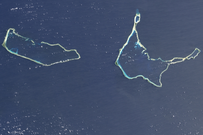
NASA’s Landsat 7 satellite acquired this image of Majuro and Arno Atolls on May 16, 2000. Both atolls appear as meandering lines of delicate white against a darker ocean background. Areas of shallow water near the shore appear iridescent blue, especially in the southwest portion of each atoll and off the northwest tip of Arno Atoll. Overhead, tiny white clouds dot the sky. Majuro Atoll is 40 kilometers (25 miles) in circumference, and it partially encloses a lagoon of nearly 300 square kilometers (115 square miles). The lagoon is far bigger than the atoll itself, whose land area is less than 10 square kilometers (4 square miles); walking from the lagoon side to the ocean side of the atoll takes only minutes. Neighboring Arno Atoll encloses three lagoons: two “pinched lagoons” in the northeast and northwest, and a main lagoon of nearly 340 square kilometers (130 square miles). Arno’s total land area is just 13 square kilometers (5 square miles). NASA image created by Jesse Allen, using Landsat data provided by the University of Maryland’s Global Land Cover Facility.
People and Society
Population: 68,480 (July 2012 est.)
Over two-thirds of the nation's population lives in Majuro and Ebeye. The outer islands are sparsely populated due to lack of employment opportunities and economic development.
The Marshallese are of Micronesian origin, which is traced to a combination of people who emigrated from Southeast Asia in the remote past. The matrilineal Marshallese culture revolves around a complex system of clans and lineages tied to land ownership.
Virtually all Marshallese are Christian, most of them Protestant.
Marshallese is the official language. English is spoken to some extent by most of the adult urban population. However, both the Nitijela (parliament) and national radio use Marshallese.
Ethnic Groups: Marshallese 92.1%, mixed Marshallese 5.9%, other 2% (2006)
Age Structure:
0-14 years: 38.2% (male 13,062/female 12,576)
15-64 years: 58.8% (male 20,171/female 19,340)
65 years and over: 3% (male 988/female 1,045) (2011 est.)
Population Growth Rate: 1.874% (2012 est.)
Birthrate: 28.14 births/1,000 population (2012 est.)
Death Rate: 4.31 deaths/1,000 population (July 2012 est.)
Net Migration Rate: -5.1 migrant(s)/1,000 population (2012 est.)
Life Expectancy at Birth: 72.03 years
male: 69.92 years
female: 74.25 years (2012 est.)
Total Fertility Rate: 3.37 children born/woman (2012 est.)
Languages: Marshallese (official) 98.2%, other languages 1.8% (1999 census). Note: English (official), widely spoken as a second language.
Literacy (age 15 and over can read and write): 93.7% (1999)
Education: The public school system provides education through grade 12, although admission to secondary school is selective. The elementary program employs a bilingual/bicultural curriculum. English is introduced in the fourth grade. Many Marshallese and American observers have lamented the poor state of the public education system as a major stumbling block to economic development. The Marshall Islands' largest secondary institution--the 2-year College of the Marshall Islands--experienced U.S. accreditation problems between 2003 and 2008. However, thanks to an increase in funding, it has shown steady improvement and has now achieved full accreditation. The University of the South Pacific offers courses at a small campus on Majuro. Specialties taught on campus are marine resources and nursing as well as basic undergraduate education courses.
Urbanization: 72% of total population (2010) growing at an annual rate of change of 2.3% (2010-15 est.)
History
Little is clearly understood about the prehistory of the Marshall Islands. Researchers agree on little more than that successive waves of migratory people from Southeast Asia spread across the Western Pacific about 3,000 years ago and that some of them landed on and remained on these islands. The Spanish explorer de Saavedra landed there in 1529. They were named for Englishexplorer John Marshall, who visited them in 1799. The Marshall Islands were claimed by Spain in 1874.
Germany established a protectorate in 1885 and set up trading stations on the islands of Jaluit and Ebon to carry out the flourishing copra (dried coconut meat) trade. Marshallese iroij (high chiefs) continued to rule under indirect colonial German administration.
At the beginning of World War I, Japan assumed control of the Marshall Islands. Their headquarters remained at the German center of administration, Jaluit. U.S. Marines and Army troops took control from the Japanese in early 1944, following intense fighting on Kwajalein and Enewetak atolls. In 1947, the United States, as the occupying power, entered into an agreement with the UN Security Council to administer Micronesia, including the Marshall Islands, as the Trust Territory of the Pacific Islands.
On May 1, 1979, in recognition of the evolving political status of the Marshall Islands, the United States recognized the constitution of the Marshall Islands and the establishment of the Government of the Republic of the Marshall Islands. The constitution incorporates both American and British constitutional concepts.
The Republic of the Marshall Islands is a sovereign nation in "free association" with the United States. After more than a decade of negotiation, the Marshall Islands and the United States signed the Compact of Free Association on June 25, 1983. The people of the Marshall Islands approved the Compact in a UN-observed plebiscite on September 7, 1983. The U.S. Congress subsequently approved the Compact, adding several amendments which were accepted by the Government of the Marshall Islands, and the Compact entered into force on October 21, 1986. From 1999-2003, the two nations negotiated an Amended Compact that entered into force on May 1, 2004. Under the Amended Compact, the U.S. will provide the Marshall Islands at least $57 million every year until 2023, including contributions to a jointly managed trust fund. Marshallese will continue to have access to many U.S. programs and services. A Joint Economic Management and Financial Accountability Committee (JEMFAC) comprised of representatives of both governments will ensure that Compact assistance funds are spent effectively.
Under the Compact, the United States has full authority and responsibility for security and defense of the Marshall Islands, and the Government of the Marshall Islands is obligated to refrain from taking actions that would be incompatible with these security and defense responsibilities.
The Department of Defense, under a subsidiary government-to-government agreement of the Compact, has use of the lagoon and several islands on Kwajalein Atoll. The atoll consists of approximately 90 islets around the largest lagoon in the world. The agreement allows the United States continued use of the U.S. Army Kwajalein Atoll (USAKA) missile test range until 2066 with an option until 2086. Another major subsidiary agreement of the original Compact provides for settlement of all claims arising from the U.S. nuclear tests conducted at Bikini and Enewetak Atolls from 1946 to 1958. Under the terms of free association, more than 40 U.S. Government agencies such as the Federal Aviation Administration, the U.S. Postal Service, the Small Business Administration, the U.S. Agency for International Development (USAID), the Department of Energy, the Department of Agriculture, and the Department of the Interior operate programs or render assistance to the Marshall Islands.
Citizens of the Marshall Islands live with a relatively new democratic political system combined with a hierarchical traditional culture. Five of the country’s six presidents have been chiefs. Former President Kessai Note is the only commoner to serve as president. Current President Christopher Loeak is a traditional chief.
There have been a number of local and national elections since the Republic of the Marshall Islands was founded, and, in general, democracy has functioned well. The United Democratic Party, running on a reform platform, won the 1999 parliamentary election, taking control of the presidency and cabinet. Elections on November 19, 2007 elected a new Nitijela that took office in January 2008, giving control of the government to the opposition, while the September 2009 vote of no confidence replaced both parties with a coalition no longer following any party lines. The Aelon Kein Ad (AKA) party won the November 2011 parliamentary elections, upsetting the governing coalition.
Government
Government Type: constitutional government in free association with the US; the Compact of Free Association entered into force on 21 October 1986 and the Amended Compact entered into force in May 2004
The legislative branch of the government consists of the Nitijela (parliament) with an advisory council of high chiefs. The Nitijela has 33 members from 24 districts elected for concurrent 4-year terms. Members are called senators. The president is elected by the Nitijela from among its members. Presidents pick cabinet members from among the members of the Nitijela. Amata Kabua was elected as the first president of the republic in 1979. Subsequently, he was re-elected to 4-year terms in 1983, 1987, 1991, and 1996. After Amata Kabua's death in office, his first cousin, Imata Kabua, won a special election in 1997. The third president, Kessai Note, served two 4-year terms from 2000 to 2008. Litokwa Tomeing was elected president in January 2008 and was removed from office in a vote of no confidence in September 2009. Jurelang Zedkaia was elected president in October 2009. Following November 2011 parliamentary elections, Christopher Loeak was elected as the sixth president of the republic.
Capital: Majuro - 30,000 (2009)
Administrative divisions: 33 municipalities; Ailinginae, Ailinglaplap, Ailuk, Arno, Aur, Bikar, Bikini, Bokak, Ebon, Enewetak, Erikub, Jabat, Jaluit, Jemo, Kili, Kwajalein, Lae, Lib, Likiep, Majuro, Maloelap, Mejit, Mili, Namorik, Namu, Rongelap, Rongrik, Toke, Ujae, Ujelang, Utirik, Wotho, Wotje
Independence Date: 21 October 1986 (from the US-administered UN trusteeship)
Legal System: mixed legal system of US and English common law, customary law, and local statutes. The Marshall Islands has not submitted an International Court of Justice (ICJ) jurisdiction declaration; but accepts International criminal court (ICCt) jurisdiction.
The Republic of the Marshall Islands has four court systems: The Supreme Court, the high court, the district and community courts, and the traditional rights court. Trial is by jury or judge. Jurisdiction of the traditional rights court is limited to cases involving titles or land rights or other disputes arising from customary law and traditional practice.
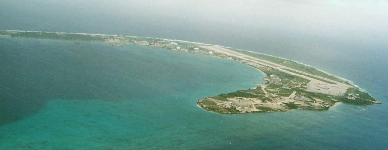
Kwajalein Atoll. Image Credit: Dirk HR Spennemann, Digital Micronesia
International Environmental Agreements
The Marshall Islands is party to international agreements on: Biodiversity, Climate Change, Climate Change-Kyoto Protocol, Desertification, Hazardous Wastes, Law of the Sea, Ozone Layer Protection, Ship Pollution, Wetlands, and Whaling.
Resources
Natural Resources: coconut products, marine products, deep seabed minerals
Land Use:
Economy
The government is the largest employer, employing approximately 46% of the salaried work force. GDP is derived mainly from payments made by the United States under the terms of the Compact of Free Association. Direct U.S. aid accounted for 62.2% of the Marshall Islands' $132.2 million budget for FY 2011.
The economy combines a small subsistence sector and a modern urban sector. Fishing and breadfruit, banana, and pandanus cultivation constitute the subsistence sector. On the outer islands, production of copra and handicrafts provides some cash income. The modern service-oriented economy is located in Majuro and Ebeye. It is sustained by government expenditures and the U.S. Army installation at Kwajalein Atoll. The airfield there also serves as a second hub for international flights.
The modern sector consists of wholesale and retail trade; restaurants; banking and insurance; construction, repair, and professional services; fisheries; and copra processing. Fish products are by far the nation's largest exports, with frozen fish being exported on large freezer ships to Asia and fresh-caught fish by air to Japan and Hawaii. A tuna loining plant that employs 600 workers--starting at $1.50 per hour--reopened in early 2008. Copra production, previously the single most important commercial activity for the past 100 years, now depends on government subsidies. The subsidies, more a social policy than an economic strategy, are intended to help reduce migration from outer atolls to densely populated Majuro and Ebeye. Migration from the outer islands is estimated at 8% annually.
Marine resources, including fishing, aquaculture, tourism development, and agriculture, are government development priorities. The Marshall Islands sells fishing rights to other nations as a source of income. Since 1990, the Marshall Islands has offered ship registrations under the Marshall Islands flag. It now registers about 2,500 vessels, the third-largest fleet in the world, and receives an income of $4 million annually. As a small nation, the Marshall Islands must import a wide variety of goods, including foodstuffs, consumer goods, machinery, and petroleum products.
The tourist industry, now a small source of foreign exchange employing less than 10% of the labor force, remains the best hope for future added income.
The islands have few natural resources, and imports far exceed exports.
Under the terms of the Amended Compact of Free Association, the US will provide millions of dollars per year to the Marshall Islands (RMI) through 2023, at which time a Trust Fund made up of US and RMI contributions will begin perpetual annual payouts.
Government downsizing, drought, a drop in construction, the decline in tourism, and less income from the renewal of fishing vessel licenses have held GDP growth to an average of 1% over the past decade.
GDP: (Purchasing Power Parity): $133.5 million (2008 est.)
GDP: (Official Exchange Rate): $161.7 million (2008 est.)
GDP- per capita (PPP): $2,500 (2008 est.)
GDP- composition by sector:
agriculture: 31.7%
industry: 14.9%
services: 53.4% (2004 est.)
Agricultural products: coconuts, tomatoes, melons, taro, breadfruit, fruits; pigs, chickens
Industries: copra, tuna processing, tourism, craft items (from seashells, wood, and pearls)
Currency: US dollar