Northwestern Forested Mountains ecoregion (CEC)
| Topics: |
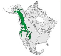
This ecological region extends from Alaska south through southern Yukon, interior British Columbia and the Alberta foothills, through northern California and over into Nevada. It contains the highest mountains of North America and some of the continent’s most diverse mosaics of ecosystem types, ranging from alpine tundra to dense conifer forests to dry sagebrush and grasslands. There are major river systems, including the headwaters to both the Fraser and Columbia rivers. The basis for aggregating all this diversity into one ecological region is topographic— the chains of mountains that traverse its whole length. This region of 800,000 people is a major tourist area for skiing, hiking and other outdoor recreational pursuits. Substantial forestry and mining activity occur throughout.
Physical Setting
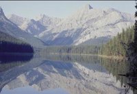
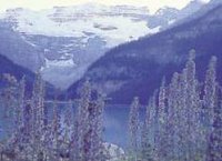
This ecological region consists of extensive mountains and plateaus separated by wide valleys and lowlands. Most of these plains and valleys are covered by moraine and, to some degree, fluvial and lacustrine deposits, whereas the mountains consist largely of colluvium and rock outcrops. Numerous glacial lakes occur at higher elevations. Soils are variable, encompassing shallow soils of alpine sites and nutrient-poor forest soils of the mountain slopes, as well as soils suitable for agriculture and those rich in calcium that support natural dry grasslands.

The climate is sub-arid to arid and mild in southern lower valleys, humid and cold at higher elevations within the central reaches, and cold and sub-arid in the north. Moist Pacific air (Air masses and frontal transitional zones) and the effect of orographic rainfall control the precipitation pattern such that both rain shadows and wet belts are generated, often in close geographic proximity to each other. The rain shadow cast by the massive coast mountains results in a relatively dry climate. The Rocky Mountains also impede the westward flow of cold, continental Arctic [[air (Air masses and frontal transitional zones)] masses]. Mean annual temperatures range between –6°C in the north to 7°C to 10°C in south. Mean summer temperatures range from 10°C to 21°C, whereas mean winter temperatures range from –23°C to 0°C. Annual precipitation varies with elevation, from 2,600 millimeters (mm) in the Cascade mountains to the north, to 400 mm in other mountainous areas, to between 250–500 mm in the valleys.
Biological Setting
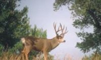
Vegetative cover is extremely diverse: alpine environments contain various herb, lichen and shrub associations; whereas the subalpine environment has tree species such as lodgepole pine, subalpine fir, silver fir, grand fir, and Engelmann spruce. With decreasing elevation, the vegetation of the mountainous slopes and rolling plains turns into forests characterized by ponderosa pine; interior Douglas fir; lodgepole pine and trembling aspen in much of the southeast and central portions; and western hemlock, western red cedar, Douglas fir and western white pine in the west and southwest. White and black spruce dominate the plateaus of the north. Shrub vegetation found in the dry southern interior includes big sagebrush, rabbit brush and antelope brush. Most of the natural grasslands that existed in the dry south have vanished, replaced by urban settlement and agriculture. Characteristic mammals include mule deer, elk, moose, mountain goat, California bighorn sheep, coyote, black and grizzly bear, hoary marmot and Columbian ground squirrel. Typical bird species include blue grouse, Steller’s jay and black-billed magpie.
Human Activities
Commercial forest operations have been established in many parts, particularly in the northern interior sections. Mining, oil and gas production, and tourism are the other significant activities. In the eastern Rocky and Columbia mountains, however, national and provincial parks have been established for recreational use or as reserves for wildlife habitat. It is mainly in the valleys that areas have been improved for range or are farmed. The southern valleys are important for their orchards and vineyards. More than half of the region’s 800,000 people live in cities and towns. The larger cities include Whitehorse, Prince George, Kamloops, Banff, Thedford, South Lake Tahoe, LaGrande, Kalispell, Steamboat Springs and Jackson.
| Disclaimer: This article is taken wholly from, or contains information that was originally published by, the Commission for Environmental Cooperation. Topic editors and authors for the Encyclopedia of Earth may have edited its content or added new information. The use of information from the Commission for Environmental Cooperation should not be construed as support for or endorsement by that organization for any new information added by EoE personnel, or for any editing of the original content. |