Natural Resource Damage Assessment: evolution, current practice, and preliminary findings related to the Deepwater Horizon oil spill

Administrator Lubchenco, Chair Sutley, Secretary Salazar, and Administrator Jackson visit the Delta National Wildlife Refuge in Louisiana August 18, 2010. Credit: Tami Heilemann/WhiteHouse.gov
Editor's Note: This article is excerpted directly from National Commission on the BP Deepwater Horizon Oil Spill and Offshore Drilling, "Natural Resource Damage Assessment: Evolution, Current Practice, and Preliminary Findings Related to the Deepwater Horizon Oil Spill," Staff Working Paper No. 17. It has been edited only to conform to the Encyclopedia's style guidelines.
Six months after the oil has stopped flowing from BP’s damaged Macondo well, the amount of environmental harm caused by the spill is uncertain, as is the adequacy of existing legal, regulatory, and policy mechanisms to ensure that restoration needed to redress the damage will be fully implemented by government and paid for by responsible parties. This background paper describes the process that was established under the Oil Pollution Act of 1990 for assessing natural resource damages caused by the spill and restoring damaged resources to their pre-spill condition. Known as Natural Resource Damage Assessment (NRDA), this process is still in the early phases of being applied to the BP spill and conclusions about its efficacy or success in this instance will be impossible to draw for a number of years, possibly decades. This background paper describes the history and purpose of the NRDA, reviews the main steps in the NRDA process, and reports on the status of current damage assessment efforts in the Gulf.
Contents
Natural Resource Damage Assessment: History and Purpose
 Credit: RestoretheGulf.gov Credit: RestoretheGulf.gov
|
In the wake of the Exxon Valdez disaster in 1989, Congress passed legislation specifically aimed at responding to and addressing environmental and economic damages from oil spills. As part of the Oil Pollution Act of 1990 (OPA), 33 U.S.C. §§ 2701 et seq., “responsible parties”1 were made liable for the removal costs and damages resulting from discharges of oil from vessels or facilities. Among other things, this liability extends to:
Damages for injury to, destruction of, loss of, or loss of use of, natural resources, including the reasonable costs of assessing the damage, which shall be recoverable by a United States trustee, a State trustee, an Indian tribe trustee, or a foreign trustee.2
The measure of damages under OPA is:
(A) The cost of restoring, rehabilitating, replacing or acquiring the equivalent of, the damaged natural resources;
(B) The diminution in value of those natural resources pending restoration; plus
(C) The reasonable cost of assessing those damages.3
Under OPA, responsibility for promulgating regulations to guide the assessment of natural resource damages fell to the National Atmospheric and Oceanic Administration (NOAA).4 NOAA completed this task in 1996 and NRDA regulations became effective on February 5, 1996.5
Prior to 1990, natural resource damage assessments and the associated cost recovery for oil spills were governed by the Comprehensive Environmental Response, Compensation and Liability Act of 1980, or CERCLA, which imposes liability for damages resulting from releases of “hazardous substances” as defined by the statute.6 CERCLA regulations provided the model for the natural resource damage assessment authority set forth in OPA and continued to govern damage assessments for oil spills between 1990 and 1996, when NOAA (National Oceanic and Atmospheric Administration (NOAA), United States) was developing new regulations under OPA.
In its OPA regulations, NOAA seeks to promote cooperation between the trustees and the responsible party in carrying out the natural resource damage assessment. This process, referred to as a cooperative assessment, is being used in the Deepwater Horizon case, where BP (a “responsible party”7) is working with government agencies (i.e., the “trustees”) to identify and quantify damages.8 NOAA guidance documents set forth the specifics of the cooperative process, including level of participation, dispute resolution, agreement on scientific methods, sharing of equipment and experts, and funding.9 As the guidance suggests, these issues are generally laid out in a memorandum of agreement between the trustees and the responsible party.10 While past attempts to use the cooperative assessment process did not measurably shorten the time or administrative costs incurred between the event and final settlement, trustees are quick to point out that the cooperative assessment process provides other advantages.11 In particular, states that do not have dedicated natural resource damage assessment programs12 maintain that they would not have the budget or resources to carry out damage assessments if not for the cooperative agreement that allows for periodic funding and the sharing of equipment and experts. Further, one trustee also pointed out that the more recent emphasis on data collection – as opposed to making assumptions based on past spills or existing scientific knowledge – to quantify damages and reach settlement has lengthened the time to settlement but strengthened the process and its outcome.
Natural Resource Damage Assessment versus Civil and Criminal Penalties
 An oiled shoreline in Barataria Bay, Louisiana. Credit: NOAA An oiled shoreline in Barataria Bay, Louisiana. Credit: NOAA
|
It is important to highlight the distinction between legal action to recover costs for damages to natural resources, and enforcement actions aimed at imposing civil or criminal penalties on the responsible party under an environmental statute. Both actions may be pursued, under separate authority, by states and the federal government in response to an event such as an oil spill. In bringing an enforcement action for civil or criminal penalties, the Department of Justice – on behalf of EPA, the Coast Guard, or another agency – acts in the role of prosecutor. By contrast, when the Department of Justice sues to recover natural resource damages, it is acting on behalf of the trustees with jurisdiction over the injured resources and the action is in many ways similar to a tort action.13 As a general rule, funds recovered as a result of civil or criminal enforcement actions under federal environmental statutes are deposited in the federal treasury and may not be used to redress the harms caused by the pollution event or incident.14 The authority to recover costs for damages to natural resources, conversely, is unique in that the funds recovered from responsible parties must be used to restore the specific resources injured by the event.15
Understanding the NRDA Process
NRDA is the regulatory process used by designated natural resource trustees to identify, assess and restore damages to: (1) public natural resources, (2) the ecosystem services they provide (e.g. oysters provide water filtration) and (3) the public’s lost use of those resources. Based on the damage assessment, the trustees either bring a lawsuit against the responsible party to recover the damages (which may be settled), or enter into a settlement with the responsible party without filing a lawsuit.
When an oil spill occurs, the trustees must work through three phases to determine the appropriate type and amount of restoration required to compensate the public:
- Preliminary Assessment (also referred to as pre-assessment). In the aftermath of the release, the trustees collect time-sensitive data and observations and conduct research to determine if damage to a particular resource has occurred or is likely to occur. Did damage likely occur? If so, the trustees move to the next phase.
- Restoration Planning (including injury assessment). In this phase, the trustees conduct scientific and economic studies to quantify damages and use local knowledge and expertise to identify potential restoration projects. A draft restoration plan describing potential compensatory restoration projects and recommending preferred projects based on applicable regulatory criteria is made available to the public for review and comment. The National Environmental Policy Act requires that any potentially significant environmental impacts of the proposed restoration activities be considering during the process of reviewing the draft plan.16
- Restoration Implementation. At this point, the restoration plan as proposed by the trustees and reviewed by the public is implemented and monitored to ensure its success.
Though the logic of this progression is straightforward, its implementation is anything but. Identifying and quantifying damages, particularly where complex ecosystems are involved, presents enormous challenges. Developing sound sampling protocols that cover adequate time scales, teasing out other environmental disturbances, and scaling the damages to the appropriate restoration project often takes considerable time; in fact, a typical damage assessment can take years. Two sets of determinations – one concerning the baseline conditions against which damages will be assessed and the second concerning the quantification of those damages – are particularly difficult and consequential in terms of the overall assessment results.
Determining Baseline Conditions
 NRDA team checks for oil in the marsh. Credit: NOAA NRDA team checks for oil in the marsh. Credit: NOAA
|
Natural resource damages must be measured against baseline conditions. The Oil Pollution Act defines the baseline against which damages are to be measured as “. . . the condition of the natural resources and services that would have existed had the incident not occurred.”17 Making this determination, however, is inherently difficult and often highly contentious. Baseline conditions may be estimated, according to the OPA regulations, “using historical data, reference data, control data, or data on incremental changes (e.g., number of dead animals), alone or in combination, as appropriate.”18 Without a well-established and agreed-upon definition of baseline conditions, there can be no agreement about a subsequent assessment of damages or quantification of required restoration. Given that the ecological baseline can vary seasonally, annually, and over much longer time scales, it can be difficult for all parties to agree upon the exact condition of an ecosystem prior a spill. Since long-term historical data sets are often non-existent or discontinuous in many areas of the country, natural resource trustees are likely to be disadvantaged by a lack of sufficient data to fully characterize the condition and trends of relevant ecosystems prior to the incident in question.
Quantifying Damages
Once baseline conditions have been established, an effort is made to quantify damages. Notwithstanding its inherent difficulty, quantification is needed to determine the appropriate amount of restoration required to compensate for the natural resource damages that have been incurred. Scientists use various methods to measure a reduction in ecological resources and the services they provide, as well as, the public’s reduced enjoyment of the resources. These methods are highly dependent on the resource being assessed and on the proxies available for measuring the ecological function. For example, one study may use measured reductions in nutrient filtration to determine relative impact on a wetland while another may use decreased fish populations in future years to determine the relative impact the spill may have had on juvenile fish or larvae. To measure the public’s reduced enjoyment of a resource, say recreational boating, a survey might to conducted to determine if the spill forced boaters to change plans, travel further, or forego trips altogether.
Typically, there is a fluctuating ecological baseline at the time of the spill (Oil spill). Once the spill occurs there is some decrease in the function of the resources (e.g., decrease in nutrient filtration, decline in an animal population, or loss of boating opportunities). If the ecosystem is left to recover naturally, it may eventually return to baseline conditions.19 However, restoration efforts must be implemented to compensate for the damages that occur (relative to baseline) during this period of natural recovery.
There are three types of restoration options: emergency restoration, primary restoration and compensatory restoration.
- Emergency Restoration. Emergency restoration is invoked when time is of the essence to curtail a threat or reverse the damage to a particularly sensitive resource. For instance, emergency restoration would include the immediate planting of seagrass before the planting season ends for the purpose of mending damage left by response vessels. Time would be of the essence in that circumstance because the damage may worsen while waiting for the next planting season.
- Primary Restoration. Primary restoration is intended to return a damaged natural resource to baseline after an oil spill. For instance, if a spill is killing marsh grasses along a wetland edge and exacerbating marsh erosion, the trustees may opt to plant new vegetation at the site of impact to curtail or reverse the inevitable land loss.
- Compensatory Restoration. Once emergency and/or primary restoration (if implemented) and cleanup activities are completed, the trustees then quantify the remaining, or interim, natural resource damage when compared to baseline. In the end, the amount of compensatory restoration required should equal the full amount of interim natural resource damages incurred. For example, if 5000 adults birds were killed due to the spill, the responsible party must not only implement restoration to replace 5000 adult birds (e.g., buying prairie pothole land in the Midwest to dedicate to nesting habitat), it must also provide for the “production foregone,” or the impact on future generations due to the loss of the adults (which would ultimately increase the number of animals required to be restored). With compensatory restoration, there is also a matter of compensating for the period of time for which the public has lost the resource. For simplicity, assume that 500 acres of marsh is lost in 2010 due to the spill. If restoration to restore the 500 acres is not completed until 2015, then the responsible party must pay interest, in the form of additional marsh acres, on the five years that the public did not have those 500 acres. The traditional interest rate in natural resource damage assessment is three percent.
Applying the NRDA Process to the Deepwater Horizon Oil Spill
Initial Response and Organization of Damage Assessment Activities
 Natural Resource Damage Assessment crew surveying Mississippi beach for oil and dead birds. Credit USFWS Natural Resource Damage Assessment crew surveying Mississippi beach for oil and dead birds. Credit USFWS
|
When the [[Deepwater Horizon] explosion] occurred on April 20, 2010, NOAA (National Oceanic and Atmospheric Administration (NOAA), United States)’s Assessment and Restoration Division was already extremely busy conducting a number of oil spill and waste damage assessments and training activities. Ironically, the Division had just participated in a drill aimed at testing preparations for a “spill of national significance” (the drill took place in Portland, Maine in late March 2010). While such a spill had never been declared before, the Division was focused on evaluating and developing lessons learned from the drill, in coordination with its sister division, the NOAA (National Oceanic and Atmospheric Administration (NOAA), United States) Emergency Response Division, participating co-trustees, and the acting responsible party and sponsor for the drill, Shell Oil Company.
The Assessment and Restoration Division was first notified of the [[Deepwater Horizon] explosion] via a hotline report generated by NOAA’s Chief Scientific Support Coordinator, Charlie Henry, in early morning hours of April 21, 2010. The initial report indicated that there were fatalities, there was oil on board the rig, and the rig was burning. At this point, the standard procedure for the Division is to stand by and initiate contact with other federal and potentially affected state and tribal trustees. By April 25, the Assessment and Restoration Division was on-scene in Houma, Louisiana and ready to begin collecting time-sensitive data that would help establish the toxicity of the oil and the baseline condition of potentially affected resources. By late April, the trustees were holding daily conference calls to provide situational updates and to construct and adapt future field sampling plans. By Saturday, May 1, experienced environmental and contaminant scientists from Florida, Alabama, and Mississippi, along with various academic institutions, began collecting coastal baseline data in anticipation of the oil reaching their respective coastlines. In Houma, NOAA, the State of Louisiana, and the Department of the Interior began organizing technical working groups and collecting baseline data along the Louisiana coast. Texas, with an experienced damage assessment program in place, was also engaged and was monitoring the movement of oil from the spill. The delay between the day of the explosion and the day the oil finally reached the coastline allowed the trustees to organize and collect vital baseline data over a large portion of the Gulf coastline and intermediate waters. Figure 1 lists the trustee agencies currently involved in the Deepwater Horizon damage assessment.
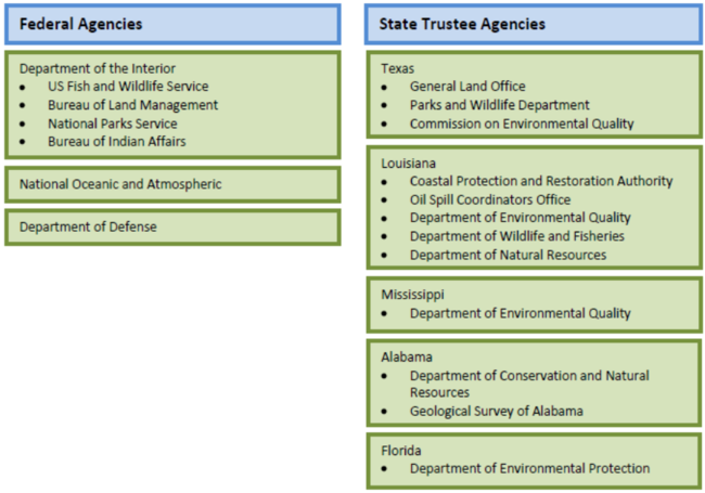 Figure 1: With two federal and 12 state agencies participating in the Deepwater Horizon NRDA process, coordinating schedules, reviewing documents, and communicating effectively across so many trustee agencies is complicated. Figure 1: With two federal and 12 state agencies participating in the Deepwater Horizon NRDA process, coordinating schedules, reviewing documents, and communicating effectively across so many trustee agencies is complicated.
|
In the days following the [[Deepwater Horizon] explosion], it became clear to NOAA’s Assessment and Restoration Division that this was a generational spill that would require the majority of Division staff and resources to conduct a comprehensive damage assessment. State agencies with ad hoc natural resource damage assessment programs scrambled to provide staff that would be dedicated to the spill long-term. Two week rotational staffing assignments were quickly put in place and emergency contracts for technical support staff were activated. Charlie Henry, NOAA’s Chief Scientific Support Coordinator for the spill warned that the response and impact assessment of this release would not be a sprint; it would be a marathon.
 Contaminants biologist looking at oil spill boom. Credit: USFWS Contaminants biologist looking at oil spill boom. Credit: USFWS
|
By early May, BP and the trustees agreed to work under the cooperative assessment framework to assess potential damages from the spill. Whether this process will work as intended under the OPA guidance remains uncertain at this time. In September, the trustees requested that BP fund several emergency and/or primary restoration projects to curtail impacts to migratory birds, submerged aquatic vegetation and [[wetland]s]. BP agreed to fund these projects and a migratory bird emergency restoration project has begun in Mississippi.20
At present, damage assessment activities being carried out across the Gulf are being managed from a central “war room” at the Incident Command Center in Houma, Louisiana. Needless to say, the scale of the undertaking represents new challenges for everyone involved – not only in terms of the geographic scale of the area being studied (both horizontally and vertically), but also in terms of the sophistication of the oceanographic equipment and the breadth of expertise being tapped to conduct the assessment. Scientists are observing oiled shorelines, tracking marine mammals, assessing fisheries impacts, and collecting water, oil, and sediment samples. BP and the trustees also have a handful of dedicated research vessels collecting data throughout the water column at various intervals.
Status and Early Results of the Damage Assessment Effort
As the language of the OPA regulations indicate, “baseline” for purposes of damage assessment in the NRDA context is generally considered to be the condition of the resource just prior to the spill. The precise application of this definition has particular importance in the [[Gulf] of Mexico] context, where many coastal habitats have been substantially degraded over decades – even centuries – under the pressure of ever-expanding industrial, commercial, and residential development. The NRDA regulations, as generally applied, require that BP restore [[Gulf] resources] to their functioning level as of April 19, 2010. However, the [[Gulf] ecosystem] in April 2010 was already weakened. Every year in the Gulf, for example, nutrient runoff from farms throughout the Mississippi River watershed creates a “dead zone” of extremely low oxygen levels in which few water organisms can survive. In some years, the area affected by this dead zone is as large as New Jersey. Throughout the region, erosion and destabilization of wetlands has been accelerated by the patchwork of canals carved out by the oil and gas industry. Cut off from natural deposits of sediment from the Mississippi River, delta wetlands have been unable to keep pace with rising sea levels and are sinking into the Gulf. These are only a few of the factors contributing to an imbalanced and already degraded [[Gulf] ecosystem]. In this context, effective long-term restoration will require the stabilization and eventual reversal of a number of long-standing, damaging trends.
As a first step in assessing damages from the [[Deepwater Horizon] spill], state and federal trustees identified numerous categories of resources that might be at risk of adverse impacts, and began developing and carrying out preliminary assessment plans. Table 1 lists the specific resources being studied by the trustees and BP through their technical representative, Entrix, as part of the damage assessment process.
|
|
 Table 1: The trustees are currently assessing potential damages to the following resource. If there is a determination that an injury occurred the magnitude of the injury will be quantified as part of the restoration planning phase. Table 1: The trustees are currently assessing potential damages to the following resource. If there is a determination that an injury occurred the magnitude of the injury will be quantified as part of the restoration planning phase.
|

On September 29, the Trustees announced that they had found sufficient evidence of natural resource damage to file a Notice of Intent to Conduct Restoration Planning. This legal document signals a move from pre-assessment activities to “identify and document impacts to the [[Gulf]’s natural resources], and the public’s loss of use and enjoyment of these resources, as the first stage under the regulations for developing a restoration strategy.”21
As of mid-January 2011 over 28,000 water, sediment, tissue and tar ball samples have been collected and over 52,000 analyses completed.22 These samples were collected during 89 off-shore research cruises and along approximately 4,215 linear miles of coastal shoreline.23
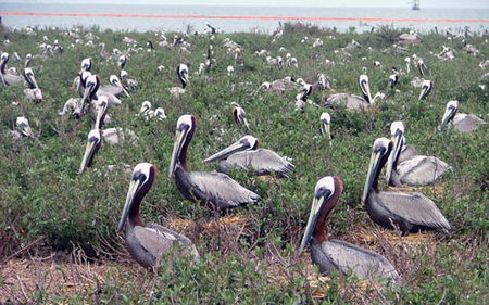
As of November 1, 2010 wildlife responders had collected 8,183 birds, 1,144 sea turtles and 109 marine mammals, alive and dead; oiled and unoiled. These numbers may have increased since then, but presumably, because the oil stopped flowing several months ago, the numbers will soon plateau if they have not already done so. Given that collection efforts are bound to miss some number of affected animals, many of which will never be found because of the effects of hiding, scavenging, sinking, decomposition, or the sheer size of the search area, the trustees will have to make assumptions to quantify impacts on wildlife. A common practice is to assign a multiplier to the final observed number of affected animals. The multiplier will vary depending on the species, its behavior, and its habitat. The multiplier is then used to estimate the total number of animals impacted.
Results of the assessment effort to date indicate that more than 650 miles of Gulf coastal habitats—salt marsh, mudflat, mangroves (Mangrove ecology), and sand beaches—were oiled; more than 130 miles have been designated as moderately to heavily oiled. Oiled birds and beaches are often the most visually disturbing and widely disseminated images associated with a major oil spill, however, public and scientific concern in the Deepwater Horizon case has for some time focused on the impacts of an invisible sub-surface “plume” or “cloud” of oil. As part of the response and damage assessment effort being coordinated by BP and the trustees, 23 research vessels have been working to collect thousands of data points over 5000 feet of water column to assess potential impacts on subsurface biota, both from the oil and from the use of dispersants.
While the biological impacts are not fully yet understood, the National Incident Command’s Joint Analysis Group, an inter-agency workgroup that was set up to analyze sub-surface data collected by scientists from federal, private, and academic institutions, released a report that described the chemical behavior of the subsurface oil.24 The report summarizes 419 data points collected from 9 different vessels between May 8, 2010 and August 9, 2010. According to these data, depressed oxygen levels have been detected more than 80 km from the wellhead. The report concludes that while oxygen levels are depressed in the subsurface plume as a result of biodegradation (referred to in the report as biochemical oxygen demand), oxygen levels that would be detrimental to water column organisms have not been found and are not expected.
The Contribution from Non-Governmental Scientists
 Credit: RestoretheGulf.gov Credit: RestoretheGulf.gov
|
Three peer-reviewed studies have been published to date in Science related to the behavior of oil from the [[Deepwater Horizon] spill] in the deep sea environment. Another publication focuses on the potential toxicity of oil in the deep sea. Camilli et al. discovered, tracked and sampled a deepwater plume of dispersed hydrocarbons measuring at least 35 km long by 2 km wide and 200 m high at a depth of about 1100 m below the ocean surface from June 19 to June 28, 2010.25 Interested, in part, as to whether microbial degradation of the plume would result in lethal depletion of oxygen in the water column26 – or a “hypoxic zone” – the research team found no significant drawdown of oxygen inside the plume. However, they do note that a hypoxic zone could ultimately develop over a period of time, as the microbes continue to degrade the oil therein: “[I]f the hydrocarbons are indeed susceptible to biodegradation, then it may require many months before microbes significantly attenuate the hydrocarbon plume to the point that oxygen minimum zones develop that are intense enough to threaten [[Gulf] fisheries (Gulf of Mexico)].”27
Hazen et al. measured physical, chemical and microbiological properties of water samples taken from the same research area as Camilli, et al. from May 25 to June 2, 2010.28 They report similar findings of only slight oxygen drawdown, and contend that the rate of biodegradation inside the plume is much faster than reported by Camilli et al.
Valentine et al. investigated dissolved hydrocarbon gases (methane, ethane, and propane) in the [[Gulf] of Mexico] water column from June 11 to 21, 2010.29 This study again confirms the presence of the southwest plume at an average depth of 1100 m and identifies additional plumes, defined by elevated levels of methane, to the north and east of the well head, which probably were formed earlier when currents flowed in a different direction. The study suggests that the microbes in the plume have a preference for the lighter petroleum constituents (ethane and propane). They conclude, therefore, that the aging plume, once devoid of the lighter constituents, have bacterial populations that are primed for degradation of other hydrocarbons, but at a slower rate.
As of mid-January, one scientific study on the potential toxicity of this deep sea plume has been published.30 Water samples collected from the discovered plume (discussed above) in mid-May contained levels of polycyclic aromatic hydrocarbon (Health effects of Polycyclic aromatic hydrocarbons) (PAH) that are high enough to be acutely toxic for some marine organisms. The PAH levels decreased with distance from the wellhead and persisted as far as 13 km from the source.
Taken together, these studies show the presence of deepwater plumes of highly dispersed oil droplets and dissolved gases between at 1000 and 1300 meters deep. Bacterial decomposition begins quickly for the light hydrocarbon gases propane and ethane but more slowly for the heavier hydrocarbons typically present in a liquid form and for the predominant gas, methane. The degradation rates are sufficient to reduce the dissolved oxygen concentrations, but not to harmfully low levels associated with “dead zones.” Subsequent dilution with well-oxygenated, uncontaminated waters is sufficient to prevent any further drawn down of dissolved oxygen in the aging plumes. While oxygen levels do not appear to be lethal and the plume will dissipate with time, the PAH levels that accumulated in the deep sea plume likely had adverse and potentially acute effects on marine organisms that need to be further assessed and quantified.
Historical Comparison
| Oil reaching the wetlands on the coast of Louisiana in May, 2010. Credit: AP |
Human nature cannot resist the temptation for disaster comparison. Hence, the question is often asked, how does this spill compare to a previous oil spill volume record holder, the Exxon Valdez oil spill? At this point, because data are still being collected on water column and fisheries impacts, it is too soon to tell whether the immediate effects of the [[Deepwater Horizon] oil spill] on coastal areas and wildlife will turn out to be smaller in scale than those associated with the Exxon Valdez oil spill. Based on current information on marine life fatalities, that remains a possibility. In the aftermath of the Exxon Valdez, for example, more than 35,000 dead birds and 1,000 dead sea otters were recovered. Additionally, that spill oiled 1500 miles of Alaska coastline, of which 350 miles were heavily oiled. Those Exxon Valdez numbers are higher than currently known numbers for the [[Deepwater Horizon] spill]. At the end of their assessment, the Exxon Valdez Trustee Council estimated the final wildlife death toll to be “250,000 seabirds, 2,800 sea otters, 300 harbor seals, 250 bald eagles, up to 22 killer whales, and billions of salmon and herring eggs.”31 Because, however, the [[Deepwater Horizon] spill] has not been fully assessed and was of a very different character, most notably occurring in the subsea, a focus on readily discernible surface expressions of harm measured by known marine life impacts may not ultimately prove to be a fair basis for comparison.
Next Steps in the Damage Assessment and Restoration Process
The data collected as part of the damage assessment process will at some point be evaluated by resource specialists for both the trustees and BP. Given that there is no way to exactly quantify the extent of shoreline oiling or the number of birds or other wildlife impacted, the final damage assessment will inevitably consist of estimates developed on the basis of careful examination of the field data (including on-going studies), comparisons to existing baseline data, reviews of the relevant literature, and much debate among the parties involved. Best professional judgment will be needed where data gaps or uncertainty exist.
When the trustees reach a conclusion as to the extent and nature of the damages that occurred and the appropriate amount of restoration required to compensate for the damages, then the matter may proceed to litigation, and be resolved by either court order or settlement. Or, in the spirit of cooperative assessment, the parties may reach a settlement without any litigation. Once a settlement is reached, depending on the terms of the settlement, the responsible party may have two choices. It can opt to implement the required amount of restoration with trustee oversight, or it can pay the trustees to implement the required restoration. Either way, the terms of the agreement are memorialized through a consent decree which must be approved by the Department of Justice.
Finally, with numerous studies ongoing, both under the auspices of the formal damage assessment process and outside it, the published literature regarding environmental impacts from the [[Deepwater Horizon] spill] can be expected to grow substantially in the months and years ahead.
Sources of additional information on the NRDA process:
- NOAA’s Damage Assessment Remediation and Restoration Program: http://www.gulfspillrestoration.noaa.gov/
- NOAA’s Office of Response and Restoration: www.deepwaterhorizon.noaa.gov
- US Fish and Wildlife Service: http://www.fws.gov/home/dhoilspill/restoration.html
- Online tool that provides you with near-real time information about the response effort. Developed by NOAA with the Environmental Protection Agency, U.S. Coast Guard, and the Department of the Interior, the site offers you a “one-stop shop” for spill response information: www.geoplatform.gov
- Data from the Department of Energy, the Environmental Protection Agency, the National Oceanic and Atmospheric Administration, the Department of the Interior, and the states of Florida and Louisiana related to the spill, its effects, and the cleanup effort: www.data.gov/restorethegulf
End Notes
1 In the case of offshore facilities, “responsible party” is defined as the “lessee or permittee of the area in which the facility is located or the holder of the right of use and easement granted under applicable State law or the Outer Continental Shelf Lands Act for the area in which the facility is located (if the holder is a different person than the lessee or permittee) . . .”). 33 U.S.C. § 2701(32).
2 33 U.S.C. § 2702(b)(2)(A). Trustees act “on behalf of the public” as trustees for natural resources. Federal trustees are designated by the President. State trustees are designated by their Governors. Affected Tribal and foreign nations can also claim trustee authority. 33 U.S.C. § 2706(b).
3 33 U.S.C. § 2706 (d)(1).
4 Ibid. at § 2706(d).
5 15 C.F.R. part 990.
6 42 U.S.C. §§ 9601 et seq. CERCLA, in turn, built on provisions in the Clean Water Act Amendments of 1977, which first codified federal authority to recover damages for natural resources. Specifically, CERCLA provided additional direction concerning the measure of damages, the use and effect of natural resource damage assessments, and the designation of trustees.
7 BP is a responsible party, but other companies involved may be named also once liability issues are established. For the time being, BP has entered into a funding agreement with the Natural Resource Damage Trustees, and is currently reimbursing their costs. If, ultimately, other responsible parties are named, the Trustees must find them jointly and severally liable under the law.
8 Under CERCLA, by contrast, damage assessments were carried out, for the most part, in a non-cooperative and adversarial manner. Since the trustees could essentially dictate how damages would be determined, responsible parties typically opted to conduct their own assessment in preparation for a court defense should the case end up in litigation. CERCLA regulations (and OPA itself) impose a “rebuttable presumption” in favor of the trustee’s damage assessment: If the responsible party disagrees with the trustee’s assessment, it bears the burden of proving that the assessment was wrong. This regulatory arrangement often set the stage for parallel and dueling assessments, as emerged in the aftermath of the Exxon Valdez incident.
9 NOAA, Preassessment Phase: Guidance Document for Natural Resource Damage Assessment Under the Oil Pollution Act of 1990 (August 1996).
10 Ibid.
11 Confidential Commission staff interviews with state and federal trustees.
12 With the exception of a few coastal states, damage assessment training, resources, and staff are often gathered on-the-fly when a spill occurs. Expertise is pulled from within state agencies.
13 The same distinction applies in the case of actions brought by state attorneys general on behalf of state agencies.
14 There are some exceptions to this general rule. A description of the sources and uses of penalties and fines resulting from oil spills is provided in the Oil Spill Commission’s Staff Working Paper 14: “Unlawful Discharges of Oil: Legal Authorities for Civil and Criminal Enforcement and Damage Recovery.”
15 In the Exxon Valdez case, of the $900 million recovered from Exxon in a civil settlement, roughly one-fourth ($213.1 million) was used to reimburse the federal government and the State of Alaska for costs incurred in damage assessment and spill response. The remaining $686.9 million was spent in Alaska on efforts to restore resources that were directly harmed by the spill (e.g., sea birds, sea otters, whales and their habitat, etc.). If the State and federal government had brought suit solely under criminal fine or civil penalty authority, only a small portion of the funds recovered from Exxon could have been used to restore resources damaged by the spill.
16 42 U.S.C. §§ 4321-4347.
17 15 C.F.R. § 990.30 (emphasis added).
18 Ibid.
19 There are times when an ecosystem experiences a total loss in services and cannot recover naturally. In this case, the services are considered to be lost in perpetuity and compensatory restoration is calculated accordingly.
20 Email from Cynthia Dohner, U.S. Fish and Wildlife Service, January 20, 2011; “First project to restore waterfowl habitat since oil spill is underway,” WLBT-TV MS, January 21, 2011
21 Notice of Intent to Conduct Restoration Planning (pursuant to 15 C.F.R. Section 990.44) -DISCHARGE OF OIL FROM THE DEEPWATER HORIZON MOBILE OFFSHORE DRILLING UNIT AND THE SUBSEA MACONDO WELL INTO THE GULF OF MEXICO, APRIL 20, 2010.
22 Once validated, the data are being made public at www.geoplatform.gov and www.data.gov.
23 NOAA, Deepwater BP Oil Spill, Natural Resource Damage Assessment: NRDA By the Numbers, January 2011.
24 National Incident Command Joint Analysis Group, Review of Preliminary Data to Examine Oxygen Levels In the Vicinity of MC252#1: May 8 to August 9, 2010 (August 16, 2010).
25 Richard Camilli et al., “Tracking Hydrocarbon Plume Transport and Biodegradation at Deepwater Horizon,” Science 330, no. 6001 (2010): 201–204.
26 Microbes give off carbon dioxide as part of the biodegradation process which, in turn, depletes oxygen in the water column.
27 Ibid.
28 Terry Hazen et al., “Deep-Sea Oil Plume Enriches Indigenous Oil-Degrading Bacteria”, Science 330, no. 6001 (2010): 208–211.
29 David Valentine et al., “Propane Respiration Jump-Starts Microbial Response to a Deep Oil Spill,” Science 330, no. 6001 (2010): 204–208.
30 Arne-R. Diercks et al., “Characterization of Subsurface Polycyclic Aromatic Hydrocarbons at the Deepwater Horizon Site,” Geophysical Research Letters 37 (2010).
31 Exxon Valdez Oil Spill Trustee Council, Exxon Valdez Oil Spill Restoration Plan: Update on Injured Resources and Services, September 1996.