Lesotho
Source: Tjeerd Wiersma/Flickr.
Countries and Regions of the World Collection  Lesotho is a landlocked nation of nearly two million people in southern-Africa, completely surrounded by the nation of South Africa.
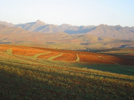
Lesotho is mostly highland with plateaus, hills, and mountains; more than 80% of the country is 1800 meters above sea level.
Lesotho's major environmental issues include: 
- population pressure forcing settlement in marginal areas results in overgrazing, severe soil erosion, and soil exhaustion;
- desertification; and,
- the Highlands Water Project which controls, stores, and redirects water to South Africa.
Basutoland was renamed the Kingdom of Lesotho upon independence from the UK in 1966. The Basuto National Party ruled for the first two decades.
King Moshoeshoe was exiled in 1990, but returned to Lesotho in 1992 and was reinstated in 1995 and subsequently succeeded by his son, King Letsie III, in 1996. Constitutional government was restored in 1993 after seven years of military rule.
In 1998, violent protests and a military mutiny following a contentious election prompted a brief but bloody intervention by South African and Botswanan military forces under the aegis of the Southern African Development Community.
Subsequent constitutional reforms restored relative political stability. Peaceful parliamentary elections were held in 2002, but the National Assembly elections of February 2007 were hotly contested and aggrieved parties continue to dispute how the electoral law was applied to award proportional seats in the Assembly.
Contents
Geography
Location: Southern Africa, an enclave of South Africa
Geographic Coordinates: 29 30 S, 28 30 E
Area: 30,355 km2 (30,355 km2 land and 0 km2 water)
Arable land: 10.87%
Permanent crops: 0.13%
Pther: 89% (2005)
Land Boundaries: 909 km. Border countries: South Africa 909 km
Natural Hazards: periodic droughts
Terrain: Mostly highland with plateaus, hills, and mountains. Its lowest point is the junction of the Orange and Makhaleng Rivers (1,400 metres) and its highest point is Thabana Ntlenyana (3,482 metres).
Climate: Because of its high altitude, the climate is temperate; with cool to cold, dry winters and with hot, wet summers.
|
Topography of Lesotho. Source: Wikimedia Commons |
Satellite view of Lesotho. Source: The Map Library |


Ecology
Map source: World Wildlife Fund |
|

People and Society
Population: 1,930,493 (July 2012 est.)
More than 99% of Lesotho's population is ethnically Basotho; other ethnic groups include Europeans, Asians, and Xhosa. The country's population is 90% Christian, the majority of whom are Roman Catholic. Other religions are Islam, Hindu, and indigenous beliefs. Sesotho and English are official languages, and other languages spoken include Xhosa.
Ethnic groups: Sotho 99.7%, Europeans, Asians, and other 0.3%,
Age Structure:
0-14 years: 33.5% (male 323,934/female 321,727)
15-64 years: 61.1% (male 573,773/female 602,443)
65 years and over: 5.4% (male 50,956/female 52,053) (2011 est.)
Population Growth Rate: 0.332% (2012 est.)
Birth Rate: 26.65 births/1,000 population (2012 est.)
Death Rate: 15.18 deaths/1,000 population (July 2012 est.)
Net Migration Rate: -8.15 migrant(s)/1,000 population (2012 est.)
Life Expectancy at Birth: 51.86 years
male: 51.77 years
female: 51.95 years (2012 est.)
Total Fertility Rate: 2.89 children born/woman (2012 est.)
Languages: Sesotho (southern Sotho), English (official), Zulu, Xhosa
Literacy (2003 est.): 84.8% (male: 74.5% - female: 94.5%)
History
Lesotho gained independence from Britain on October 4, 1966. In January 1970 the ruling Basotho National Party (BNP) appeared set to lose the first post-independence general elections when Prime Minister Leabua Jonathan annulled the election. He refused to cede power to the Basotho Congress Party (BCP) and imprisoned its leadership.
The BNP ruled by decree until January 1986 when a military coup forced the BNP government out of office. The Military Council that came into power granted executive powers to King Moshoeshoe II, who was until then a ceremonial monarch. In 1990, however, the King was forced into exile after a falling out with the army. His son was installed as King Letsie III.
The chairman of the military junta, Major General Metsing Lekhanya, was ousted in 1991 and then replaced by Major General Phisoane Ramaema, who handed over power to a democratically elected government of the BCP in 1993. Moshoeshoe II returned from exile in 1992 as an ordinary citizen. After the return to democratic government, King Letsie III tried unsuccessfully to persuade the BCP government to reinstate his father (Moshoeshoe II) as head of state. In August 1994, Letsie III staged a coup which was backed by the military and deposed the BCP government. The new government did not receive full international recognition. Member states of the Southern African Development Community (SADC) engaged in negotiations aimed at the reinstatement of the BCP government. One of the conditions put forward by the King for the return of the BCP government was that his father should be re-installed as head of state. After protracted negotiations, the BCP government was reinstated and the King abdicated in favor of his father in 1995, but Moshoeshoe II died in a car accident in 1996 and was again succeeded by his son, Letsie III. The ruling BCP split over leadership disputes in 1997.
Prime Minister Ntsu Mokhehle formed a new party, the Lesotho Congress for Democracy (LCD), and was followed by a majority of members of parliament (MPs), which enabled him to form a new government. The LCD won the general elections in 1998 under the leadership of Pakalitha Mosisili, who had succeeded Mokhehle as party leader. Despite the elections being pronounced free and fair by local and international observers and a subsequent special commission appointed by SADC, the opposition political parties rejected the results.
Opposition protests in the country intensified, culminating in a violent demonstration outside the royal palace in August 1998. When junior members of the armed services mutinied in September, the government requested a SADC task force to intervene to prevent a coup and restore stability. A military group of South African and Botswana troops entered the country in September, put down the mutiny, and withdrew in May 1999. Looting, casualties, and widespread destruction of property followed.
An Interim Political Authority (IPA), charged with reviewing the electoral structure in the country, was created in December 1998. The IPA devised a proportional electoral system to ensure that there would be opposition in the National Assembly. The new system retained the existing 80 elected Assembly seats, but added 40 seats to be filled on a proportional basis. Elections were held under this new system in May 2002, and the LCD won again. However, for the first time, due to the inclusion of proportional seats, opposition political parties won significant numbers of seats. The February 2007 elections resulted in another LCD victory. While acknowledging the LCD victory, opposition parties continued to assert that some of the proportional seats were allocated incorrectly. Nine parties held all 40 of the proportional seats. The National Independent Party (NIP) formed an “informal alliance” with the LCD, leading to its share of 21, the largest of any minority party.
The 2007 elections remained an active point of contention for years. Opposition parties called for the reallocation of seats, revision of the electoral law, and formal designation of a leader of opposition. The Christian Council of Lesotho (CCL) began mediating the conflict in 2009. Little progress was made until early 2011. In a major breakthrough, the CCL, with the assistance of an expert facilitated by the UN Development Program (UNDP), held a meeting in which all parties agreed on the amendments to be made to the proposed electoral bill. All parties also agreed to use a single-ballot system in future elections, eliminating the possibility of the contentious informal alliances of 2007.
On April 22, 2009, a failed assassination attempt was made on Prime Minister Mosisili at his residence. Two suspects were arrested in Lesotho, and seven suspects were arrested in South Africa. Those seven were handed over to Lesotho authorities on April 19, 2011, following a prolonged extradition process. The suspected mastermind and financier of the attempted coup is in South Africa awaiting his extradition process. The eight suspects (one died of natural causes in custody) are on trial, facing charges of murder, attempted murder, robbery, kidnapping, illegal possession of firearms, contravention of the Internal Security Act of Lesotho, and conspiracy to kill the Prime Minister.
After a year of internal LCD fighting, Prime Minister Mosisili fired the Communications Minister and the Minister to the Prime Minister’s Office in late January 2012. In February 2012, the Prime Minister and 44 supporters abandoned the LCD but remain in power with a new party, the Democratic Congress (DC). Of the 80 constituency-based seats, the DC now controls 45, the LCD 21, and the All Basotho Convention (ABC) 11. On February 29, parliament passed a symbolic motion of confidence in the Prime Minister as the opposition parties walked out in protest. Parliament’s term ends on March 15, and national elections must follow within 90 days.
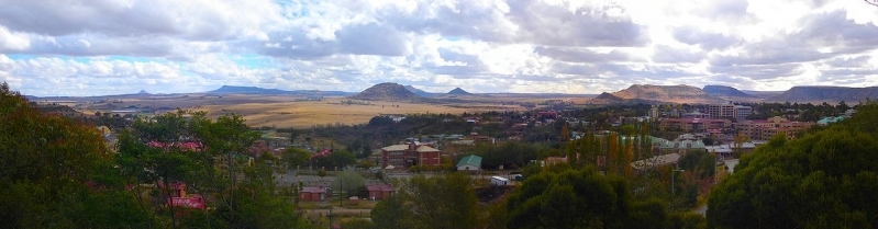
Panorama view of Maseru, looking towards its border with South Africa. Downtown Maseru is to the right of the image. Source: Wikimedia Commons.
Government
Government Type: Parliamentary constitutional monarchy
The Lesotho Government is a constitutional monarchy. The Prime Minister is head of government and has executive authority. The King serves a largely ceremonial function; he does not actively participate in political initiatives.
The newly-formed Democratic Congress controls a majority in the National Assembly (the lower house of parliament), with the Lesotho Congress for Democracy, the All Basotho Convention, the National Independent Party, and the Lesotho Workers Party among the 11 opposition parties represented. Parliamentary elections are due to take place in May 2012. The upper house of parliament, called the Senate, is composed of 22 principal chiefs, whose membership is hereditary, and 11 other members appointed by the ruling party.
The constitution provides for an independent judicial system. The judiciary is made up of the Court of Appeal, the High Court, Magistrate's Courts, and traditional courts that exist predominately in rural areas. All but one of the Justices on the Court of Appeal are South African jurists. There is no trial by jury; rather, judges make rulings alone, or, in the case of criminal trials, with two other judges as observers. The constitution also protects basic civil liberties, including freedom of speech, association, and the press; freedom of peaceful assembly; and freedom of religion.
Lesotho held its first post-independence local government elections in 2005 using a quota system that reserved one-third of electoral divisions for women candidates. In these elections, 53% of the victorious candidates were women. Locally-elected officials attended post-election training while the National Assembly created regulations for local governance and the Ministry of Local Government built supporting infrastructure. The most recent local government elections took place in October 2011, when the then-ruling party, Lesotho Congress for Democracy, won 69 of the 77 contested councils.
|
Capital: Maseru - 220,000 (2009) Administrative Divisions: For administrative purposes, Lesotho is divided into 10 districts, each headed by a district administrator:
Independence Date: 4 October 1966 (from UK) |
Source: Johan van der Heyden/Wikimedia Commons |

Legal System: based on English common law and Roman-Dutch law; judicial review of legislative acts in High Court and Court of Appeal; accepts compulsory International Court of Justice jurisdiction with reservations
Suffrage: 18 years of age; universal
International Environmental Agreements
Lesotho is party to international agreements on: Biodiversity, Climate Change, Climate Change-Kyoto Protocol, Desertification, Endangered Species, Hazardous Wastes, Law of the Sea, Marine Life Conservation, Ozone Layer Protection, and Wetlands.
Water
Total Renewable Water Resources: 5.2 cu km (1987)
Freshwater Withdrawal: Total: 0.05 cu km/yr (40% domestic, 40% industrial, 20% agricultural). Per capita: 28 cu m/yr (2000)
Agriculture
Agricultural Products: corn, wheat, pulses, sorghum, barley; livestock
Irrigated Land: 30 sq km (2003)
Resources
Natural Resources: water, agricultural and grazing land, diamonds, sand, clay, building stone.
Energy
| Energy in Lesotho | |||||
| Production | Consumption | Exports | Imports | Reserves | |
| Electricity | 200 million kWh (2008 est.) |
236 million kWh (2008 est.) |
0 kWh (2009 est.) |
107 million kWh* (2009 est.) |
|
| Oil |
0 bbl/day |
2,000 bbl/day (2010 est.) |
0 bbl/day (2009 est.) |
1,690 bbl/day (2009 est.) |
0 bbl (1 January 2011 est.) |
| Natural Gas | 0 cu m (2009 est.) |
0 cu m (2009 est.) |
0 cu m (2009 est.) |
0 cu m (2009 est.) |
0 cu m (1 January 2011 est.) |
| Source: CIA Factbook | |||||
- note - electricity supplied by South Africa
Health
According to recent estimates, the HIV/AIDS prevalence rate in Lesotho is 23%, the third-highest in the world. In 1999, the government finalized its National Strategic Plan on HIV/AIDS, a diagram for addressing the education, prevention, counseling, and treatment needs of the populace. In 2000, Lesotho declared a national emergency as a result of the HIV/AIDS crisis. In 2003 the Government of Lesotho hosted a SADC Extraordinary Summit on HIV/AIDS. In 2005 legislation was passed to create the National AIDS Commission to coordinate society-wide anti-AIDS activities, which was followed by the launching of a national "Know Your Status" campaign aimed at achieving 100% testing and counseling of all Basotho. A partnership framework that is aligned with the National Strategic Plan was signed in August 2009 by the U.S. President's Emergency Plan for AIDS Relief (PEPFAR) and the Government of Lesotho.
The donor community is collaborating with the Government of Lesotho in a massive effort to address the HIV epidemic. Key international stakeholders include PEPFAR, UN agencies, Irish AID, other international donors, and dozens of non-governmental organizations.
Economy
Lesotho's economy is based on water and electricity sold to South Africa, manufacturing, receipts from the Southern African Customs Union (SACU), agriculture, livestock, and to some extent, earnings of laborers employed in South Africa. Lesotho also exports diamonds, wool, and mohair. Lesotho is geographically surrounded by and economically integrated with South Africa. The western lowlands form the main agricultural zone. The majority of households subsist on farming or migrant labor, and approximately 86% of the population relies, at least in part, on crop cultivation or animal husbandry. In 2011, agriculture accounted for an estimated 8.0% of GDP.
Water is Lesotho's most significant natural resource. It is being exploited through the 30-year, multi-billion-dollar Lesotho Highlands Water Project (LHWP), which was initiated in 1986. The LHWP is designed to capture, store, and transfer water from the Orange River system and send it to South Africa's Free State Province and greater Johannesburg area, which features a large concentration of South African industry, population, and agriculture. Completion of the first phase of the project allows Lesotho to generate approximately 80% of the electricity it consumes annually and earn approximately $24 million annually from the sale of electricity and water to South Africa. The World Bank, African Development Bank, European Investment Bank, and many other bilateral donors financed the project. Lesotho has taken advantage of the African Growth and Opportunity Act (AGOA) to become a major exporter of garments to the U.S. from sub-Saharan Africa. Exports to the U.S. under AGOA totaled $314 million in 2011, and the sector employs approximately 35,000 workers. Taiwanese and Indian investors own most factories.
Lesotho has received economic aid from a variety of sources, including the United States, the World Bank, Ireland, the United Kingdom, the European Union, Germany, and the People's Republic of China.
Lesotho has nearly 7,000 kilometers of unpaved and modern all-weather roads. There is a short rail line (freight) linking the capital city of Maseru with Bloemfontein, South Africa that is owned and operated by South Africa (the half-mile trunk inside Lesotho is operated by Lesotho Flour Mills, Ltd.). Lesotho is a member of the Southern African Customs Union (SACU) in which tariffs have been eliminated on the trade of goods with other member countries, which include Botswana, Namibia, South Africa, and Swaziland. With the exception of Botswana, these countries also form a common currency and exchange control area known as the Common Monetary Area (CMA). The South African rand can be used interchangeably with the loti, the Lesotho currency (plural: maloti). One hundred lisente equal one loti. The loti is at par with the rand.
GDP (Purchasing Power Parity): $3.672 billion (2011 est.)
GDP (Official Exchange Rate): $2.7 billion (2011 est.)
GDP- per capita (PPP): $1,400 (2011 est.)
GDP- composition by sector:
agriculture: 8.4%
industry: 34.2%
services: 57.3% (2011 est.)
Population Below Poverty Line: 49% (1999)
Industries: food, beverages, textiles, apparel assembly, handicrafts, construction, tourism
Exports: manufactures 75% (clothing, footwear, road vehicles), wool and mohair, food and live animals (2000)
Export Partners: US 79.8%, Belgium 14.5%, Canada 1.7% (2006)
Imports: food; building materials, vehicles, machinery, medicines, petroleum products
Import Partners: Hong Kong 26.2%, Taiwan 24.7%, China 24.5%, Germany 6.2%, South Korea 4.1% (2006)
Economic Aid Recipient: $68.82 million (2005)
Currency: loti (LSL); South African rand (ZAR)