Lake Huron, Ontario

| Topics: |
Physical Attributes
- Altitude: 175 m above sea level
- Surface Area: 59,570 sq. km
- Mean Depth: 59 m
- Maximum Depth: 230 m
- Volume: 3,540 cu. km
- Shoreline Length: 6,160 km
- Drainage Basin: 131,300 sq km
General Description

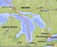
Lake Huron is the second largest of the Great Lakes. The Canadian portion of Lake Huron, however, is the greatest expanse of inland water in the country. Major sources of water to Lake Huron include the St. Mary's River from Lake Superior and a net flow from Lake Michigan through the Straits of Mackinac. In the summer, there is a flow of deep hypolimnetic water from Lake Huron into Lake Michigan. Water flows out of Lake Huron into Lake Erie via the St. Clair River. Lake Huron contains Manitoulin Island, the world's largest island in a freshwater lake. The shoreline is complex and studded with islands along the North Shore and in the eastern shore of Georgian Bay. The east and west shores of Lake Huron are characterized by sandy beaches while the Bruce Peninsula is known for its limestone cliffs. The lake is oligotrophic with the exception of the eutrophic waters of Saginaw Bay and Severn Sound. The Lake Huron fishery has been depleted from overfishing, destruction of spawning grounds, and the introduction of exotic species (lamprey eel, alewife, smelt) that compete with species native to the lake. There is also concern about the ecological sustainability of Pacific Salmon that were stocked into the lake for a sports fishery. Chemical contamination is a problem in Lake Huron where low concentrations of heavy metals, organochlorine pesticides and PCB's have been detected. Higher levels (especially lead) are found in the sediments and near industrialized centres. Acid rain from eastern North America continues to effect the poorly buffered soils of the eastern Georgian Bay watershed.
Watershed
While Precambrian Shield dominates the northern and northeastern shores of Lake Huron, the western and southeastern shores are comprised of Paleozoic bedrock characteristic of Lake Michigan. Intensive agriculture is found in the southern part of the watershed in Michigan but forests predominate in the north. Industries such as nickel and uranium mining, pulp and paper, nuclear power stations, and chemical factories all affect water chemistry in the drainage basin of Lake Huron.